![](/images/other/stat-length.png)
![Trail Walking Marœuil - Maroeuil - Mont St Eloi - Photo](https://media.geolcdn.com/t/1900/400/ext.pjpeg?maxdim=2&url=https%3A%2F%2Fstatic1.geolcdn.com%2Fsiteimages%2Fupload%2Ffiles%2F1553511878bg_sport_marche.png)
Maroeuil - Mont St Eloi
tracegps
User
![Length](/images/other/stat-length.png)
Length
10.4 km
![Max alt](https://static1.geolcdn.com/siteimages/upload/files/1508320355ic_sort_altitude_max_24dp.png)
Max alt
138 m
![Uphill gradient](https://static1.geolcdn.com/siteimages/upload/files/1508320355ic_sort_den_pos_24dp.png)
Uphill gradient
159 m
![Km-Effort](/images/other/stat-length.png)
Km-Effort
12.5 km
![Min alt](https://static1.geolcdn.com/siteimages/upload/files/1508320355ic_sort_altitude_min_24dp.png)
Min alt
66 m
![Downhill gradient](https://static1.geolcdn.com/siteimages/upload/files/1508320355ic_sort_den_neg_24dp.png)
Downhill gradient
159 m
![Boucle](https://static1.geolcdn.com/siteimages/upload/files/16400158638029165_repeat_loop_refresh_sync_direction_icon.png)
Boucle
Yes
Creation date :
2014-12-10 00:00:00.0
Updated on :
2014-12-10 00:00:00.0
![Walking](https://static1.geolcdn.com/sitytour/trail-icons/101.png)
2h00
Difficulty : Medium
![Scan this QR Code to open this trail in the SityTrail application](https://capi.geolives.com/qq0zvz2zws4bq2lad0pu/sitytour/trails/103552/qr.png?size=200)
FREE GPS app for hiking
About
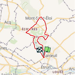
Trail Walking of 10.4 km to be discovered at Hauts-de-France, Pas-de-Calais, Marœuil. This trail is proposed by tracegps.
Description
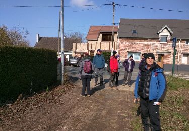
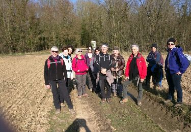
Randonnée au départ de la gare de Maroeuil, qui nous emmène faire un tour dans le bois, puis nous fait découvrir les ruines de l'abbaye du mont St Eloi et nous fait traverser les hameaux de Ecoivres et Bray.
Positioning
Country:
France
Region :
Hauts-de-France
Department/Province :
Pas-de-Calais
Municipality :
Marœuil
Location:
Unknown
Start:(Dec)
Start:(UTM)
478534 ; 5574573 (31U) N.
Comments
Trails nearby
![Trail Walking Mont-Saint-Éloi - Autour du Mont-Saint-Éloi - Photo](https://media.geolcdn.com/t/375/260/ext.jpg?maxdim=2&url=https%3A%2F%2Fservices.sitytrail.com%2FGeolivesWS%2FDownloadMedia.ashx%3FTrailID%3D215199%26Media%3D15804_6.jpg)
![Walking Walking](https://static1.geolcdn.com/sitytour/trail-icons/101.png)
Autour du Mont-Saint-Éloi
Walking
Difficult
(3)
Mont-Saint-Éloi,
Hauts-de-France,
Pas-de-Calais,
France
![](/images/other/stat-length.png)
14.3 km | 16.7 km-effort
3h 34min
![](https://static1.geolcdn.com/siteimages/upload/files/16400158638029165_repeat_loop_refresh_sync_direction_icon.png)
Yes
![Trail Walking Sainte-Catherine - Jardins et monuments - Arras - Photo](https://media.geolcdn.com/t/375/260/ext.jpg?maxdim=2&url=https%3A%2F%2Fservices.sitytrail.com%2FGeolivesWS%2FDownloadMedia.ashx%3FTrailID%3D110053%26Media%3D5162_6.jpg)
![Walking Walking](https://static1.geolcdn.com/sitytour/trail-icons/101.png)
Jardins et monuments - Arras
Walking
Medium
(3)
Sainte-Catherine,
Hauts-de-France,
Pas-de-Calais,
France
![](/images/other/stat-length.png)
9.6 km | 10.6 km-effort
2h 40min
![](https://static1.geolcdn.com/siteimages/upload/files/16400158638029165_repeat_loop_refresh_sync_direction_icon.png)
Yes
![Trail Nordic walking Mont-Saint-Éloi - Les trois abbayes - Photo](https://media.geolcdn.com/t/375/260/a20b48c3-4fa6-4de3-bf52-85a257498803.jpeg&format=jpg&maxdim=2)
![Nordic walking Nordic walking](https://static1.geolcdn.com/sitytour/trail-icons/102.png)
Les trois abbayes
Nordic walking
Easy
Mont-Saint-Éloi,
Hauts-de-France,
Pas-de-Calais,
France
![](/images/other/stat-length.png)
16.2 km | 18.9 km-effort
3h 24min
![](https://static1.geolcdn.com/siteimages/upload/files/16400158638029165_repeat_loop_refresh_sync_direction_icon.png)
Yes
![Trail Walking Dainville - le Crinchon - Photo](https://media.geolcdn.com/t/375/260/ext.jpg?maxdim=2&url=https%3A%2F%2Fservices.sitytrail.com%2FGeolivesWS%2FDownloadMedia.ashx%3FTrailID%3D537537%26Media%3Dfix__20160313105733.jpg)
![Walking Walking](https://static1.geolcdn.com/sitytour/trail-icons/101.png)
le Crinchon
Walking
Easy
Dainville,
Hauts-de-France,
Pas-de-Calais,
France
![](/images/other/stat-length.png)
24 km | 26 km-effort
5h 18min
![](https://static1.geolcdn.com/siteimages/upload/files/16400158638029165_repeat_loop_refresh_sync_direction_icon.png)
Yes
![Trail Walking Dainville - le Crinchon - Photo](https://media.geolcdn.com/t/375/260/ext.jpg?maxdim=2&url=https%3A%2F%2Fservices.sitytrail.com%2FGeolivesWS%2FDownloadMedia.ashx%3FTrailID%3D537535%26Media%3Dfix__20160313154016.jpg)
![Walking Walking](https://static1.geolcdn.com/sitytour/trail-icons/101.png)
le Crinchon
Walking
Easy
Dainville,
Hauts-de-France,
Pas-de-Calais,
France
![](/images/other/stat-length.png)
24 km | 26 km-effort
5h 18min
![](https://static1.geolcdn.com/siteimages/upload/files/16400158638029165_repeat_loop_refresh_sync_direction_icon.png)
Yes
![Trail Walking Neuville-Saint-Vaast - tour Neuville p1 - Photo](https://media.geolcdn.com/t/375/260/ext.jpg?maxdim=2&url=https%3A%2F%2Fservices.sitytrail.com%2FGeolivesWS%2FDownloadMedia.ashx%3FTrailID%3D200820%26Media%3Dfix__20130627100400.jpg)
![Walking Walking](https://static1.geolcdn.com/sitytour/trail-icons/101.png)
tour Neuville p1
Walking
Easy
Neuville-Saint-Vaast,
Hauts-de-France,
Pas-de-Calais,
France
![](/images/other/stat-length.png)
4 km | 4.5 km-effort
1h 1min
![](https://static1.geolcdn.com/siteimages/upload/files/16400158638029165_repeat_loop_refresh_sync_direction_icon.png)
No
![Trail Walking Neuville-Saint-Vaast - neuville saint vaast - Photo](https://media.geolcdn.com/t/375/260/ext.jpg?maxdim=2&url=https%3A%2F%2Fservices.sitytrail.com%2FGeolivesWS%2FDownloadMedia.ashx%3FTrailID%3D158596%26Media%3D20121018114604.jpeg)
![Walking Walking](https://static1.geolcdn.com/sitytour/trail-icons/101.png)
neuville saint vaast
Walking
Easy
(1)
Neuville-Saint-Vaast,
Hauts-de-France,
Pas-de-Calais,
France
![](/images/other/stat-length.png)
11.2 km | 12.4 km-effort
2h 35min
![](https://static1.geolcdn.com/siteimages/upload/files/16400158638029165_repeat_loop_refresh_sync_direction_icon.png)
Yes
![Trail Other activity Mont-Saint-Éloi - chemin des 3 abbayes - Photo](https://media.geolcdn.com/t/375/260/ext.jpg?maxdim=2&url=https%3A%2F%2Fservices.sitytrail.com%2FGeolivesWS%2FDownloadMedia.ashx%3FTrailID%3D145071%26Media%3D20120809123008.jpg)
![Other activity Other activity](https://static1.geolcdn.com/sitytour/trail-icons/900.png)
chemin des 3 abbayes
Other activity
Very easy
Mont-Saint-Éloi,
Hauts-de-France,
Pas-de-Calais,
France
![](/images/other/stat-length.png)
15.7 km | 18.4 km-effort
3h 12min
![](https://static1.geolcdn.com/siteimages/upload/files/16400158638029165_repeat_loop_refresh_sync_direction_icon.png)
Yes
![Trail Walking Sainte-Catherine - Au fil du Crinchon - Arras - Photo](https://media.geolcdn.com/t/375/260/ext.jpg?maxdim=2&url=https%3A%2F%2Fservices.sitytrail.com%2FGeolivesWS%2FDownloadMedia.ashx%3FTrailID%3D110054%26Media%3D5163_6.jpg)
![Walking Walking](https://static1.geolcdn.com/sitytour/trail-icons/101.png)
Au fil du Crinchon - Arras
Walking
Very difficult
Sainte-Catherine,
Hauts-de-France,
Pas-de-Calais,
France
![](/images/other/stat-length.png)
18 km | 19.6 km-effort
4h 30min
![](https://static1.geolcdn.com/siteimages/upload/files/16400158638029165_repeat_loop_refresh_sync_direction_icon.png)
Yes