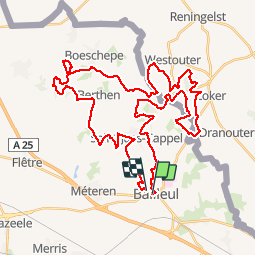
![](/images/other/stat-length.png)
![Trail Mountain bike Bailleul - Rando des Monts de Flandre - Photo](https://media.geolcdn.com/t/1900/400/ext.pjpeg?maxdim=2&url=https%3A%2F%2Fstatic1.geolcdn.com%2Fsiteimages%2Fupload%2Ffiles%2F1524743154velo.jpg)
Rando des Monts de Flandre
tracegps
User
![Length](/images/other/stat-length.png)
Length
45 km
![Max alt](https://static1.geolcdn.com/siteimages/upload/files/1508320355ic_sort_altitude_max_24dp.png)
Max alt
167 m
![Uphill gradient](https://static1.geolcdn.com/siteimages/upload/files/1508320355ic_sort_den_pos_24dp.png)
Uphill gradient
775 m
![Km-Effort](/images/other/stat-length.png)
Km-Effort
55 km
![Min alt](https://static1.geolcdn.com/siteimages/upload/files/1508320355ic_sort_altitude_min_24dp.png)
Min alt
21 m
![Downhill gradient](https://static1.geolcdn.com/siteimages/upload/files/1508320355ic_sort_den_neg_24dp.png)
Downhill gradient
796 m
![Boucle](https://static1.geolcdn.com/siteimages/upload/files/16400158638029165_repeat_loop_refresh_sync_direction_icon.png)
Boucle
No
Creation date :
2014-12-10 00:00:00.0
Updated on :
2014-12-10 00:00:00.0
![Mountain bike](https://static1.geolcdn.com/sitytour/trail-icons/202.png)
3h00
Difficulty : Difficult
![Scan this QR Code to open this trail in the SityTrail application](https://capi.geolives.com/qq0zvz2zws4bq2lad0pu/sitytour/trails/103527/qr.png?size=200)
FREE GPS app for hiking
About
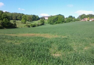
Trail Mountain bike of 45 km to be discovered at Hauts-de-France, Nord, Bailleul. This trail is proposed by tracegps.
Description
Saint-Jans-Cappel, le mont Noir ou encore le mont des Cats seront les terrains de jeu des vététistes Le summumce qu'on appelle la "montée impossible " entre Boeschèpe et Godewaersvelde, courte mais très raide.
Positioning
Country:
France
Region :
Hauts-de-France
Department/Province :
Nord
Municipality :
Bailleul
Location:
Unknown
Start:(Dec)
Start:(UTM)
481116 ; 5620919 (31U) N.
Comments
Trails nearby
![Trail Motor Bailleul - 104 - Photo](https://media.geolcdn.com/t/375/260/ext.jpg?maxdim=2&url=https%3A%2F%2Fstatic1.geolcdn.com%2Fsiteimages%2Fupload%2Ffiles%2F15247431544x4.jpg)
![Motor Motor](https://static1.geolcdn.com/sitytour/trail-icons/400.png)
![Trail Walking Saint-Jans-Cappel - sentier des jacynthes - Photo](https://media.geolcdn.com/t/375/260/ext.jpg?maxdim=2&url=https%3A%2F%2Fstatic1.geolcdn.com%2Fsiteimages%2Fupload%2Ffiles%2F1553511878bg_sport_marche.png)
![Walking Walking](https://static1.geolcdn.com/sitytour/trail-icons/101.png)
sentier des jacynthes
Walking
Medium
(1)
Saint-Jans-Cappel,
Hauts-de-France,
Nord,
France
![](/images/other/stat-length.png)
7.3 km | 9.2 km-effort
2h 1min
![](https://static1.geolcdn.com/siteimages/upload/files/16400158638029165_repeat_loop_refresh_sync_direction_icon.png)
Yes
![Trail Walking Bailleul - camping de la Ferme des Saules à côté de Bailleul, arrivée Deulemont - Photo](https://media.geolcdn.com/t/375/260/5dfd3b71-bc9e-42e1-b3be-5ab9c2cf49ac.jpg&format=jpg&maxdim=2)
![Walking Walking](https://static1.geolcdn.com/sitytour/trail-icons/101.png)
camping de la Ferme des Saules à côté de Bailleul, arrivée Deulemont
Walking
Medium
Bailleul,
Hauts-de-France,
Nord,
France
![](/images/other/stat-length.png)
32 km | 34 km-effort
9h 10min
![](https://static1.geolcdn.com/siteimages/upload/files/16400158638029165_repeat_loop_refresh_sync_direction_icon.png)
No
![Trail Walking Heuvelland - Dranouter 12,3 km - Photo](https://media.geolcdn.com/t/375/260/ab62849d-d2cc-4c63-a20f-7ad369b5fc0f.jpg&format=jpg&maxdim=2)
![Walking Walking](https://static1.geolcdn.com/sitytour/trail-icons/101.png)
Dranouter 12,3 km
Walking
Easy
Heuvelland,
Flanders,
West Flanders,
Belgium
![](/images/other/stat-length.png)
12.4 km | 14.5 km-effort
3h 32min
![](https://static1.geolcdn.com/siteimages/upload/files/16400158638029165_repeat_loop_refresh_sync_direction_icon.png)
Yes
![Trail Walking Heuvelland - Loker 18,2 km - Photo](https://media.geolcdn.com/t/375/260/95fcaf9d-4059-4e0a-91b3-686074f6c894.jpg&format=jpg&maxdim=2)
![Walking Walking](https://static1.geolcdn.com/sitytour/trail-icons/101.png)
Loker 18,2 km
Walking
Medium
Heuvelland,
Flanders,
West Flanders,
Belgium
![](/images/other/stat-length.png)
18.3 km | 23 km-effort
5h 14min
![](https://static1.geolcdn.com/siteimages/upload/files/16400158638029165_repeat_loop_refresh_sync_direction_icon.png)
Yes
![Trail Walking Boeschepe - Week-end des estaminets CAF1 - Photo](https://media.geolcdn.com/t/375/260/ext.jpg?maxdim=2&url=https%3A%2F%2Fservices.sitytrail.com%2FGeolivesWS%2FDownloadMedia.ashx%3FTrailID%3D541147%26Media%3Dfix__20160319140516.jpg)
![Walking Walking](https://static1.geolcdn.com/sitytour/trail-icons/101.png)
Week-end des estaminets CAF1
Walking
Easy
Boeschepe,
Hauts-de-France,
Nord,
France
![](/images/other/stat-length.png)
16.7 km | 21 km-effort
4h 32min
![](https://static1.geolcdn.com/siteimages/upload/files/16400158638029165_repeat_loop_refresh_sync_direction_icon.png)
Yes
![Trail Running Saint-Jans-Cappel - st jans - mont des cats - mont noir - Photo](https://media.geolcdn.com/t/375/260/ext.jpg?maxdim=2&url=https%3A%2F%2Fservices.sitytrail.com%2FGeolivesWS%2FDownloadMedia.ashx%3FTrailID%3D222369%26Media%3Dfix__20130921100616.jpg)
![Running Running](https://static1.geolcdn.com/sitytour/trail-icons/103.png)
st jans - mont des cats - mont noir
Running
Easy
Saint-Jans-Cappel,
Hauts-de-France,
Nord,
France
![](/images/other/stat-length.png)
16.8 km | 21 km-effort
1h 43min
![](https://static1.geolcdn.com/siteimages/upload/files/16400158638029165_repeat_loop_refresh_sync_direction_icon.png)
Yes
![Trail Walking Saint-Jans-Cappel - Sentier des jacinthes - Photo](https://media.geolcdn.com/t/375/260/ext.jpg?maxdim=2&url=https%3A%2F%2Fservices.sitytrail.com%2FGeolivesWS%2FDownloadMedia.ashx%3FTrailID%3D202851%26Media%3Dc9713bd7-454e-4388-9946-c6235c91c79f.jpg)
![Walking Walking](https://static1.geolcdn.com/sitytour/trail-icons/101.png)
Sentier des jacinthes
Walking
Very easy
(1)
Saint-Jans-Cappel,
Hauts-de-France,
Nord,
France
![](/images/other/stat-length.png)
6.3 km | 8.1 km-effort
Unknown
![](https://static1.geolcdn.com/siteimages/upload/files/16400158638029165_repeat_loop_refresh_sync_direction_icon.png)
Yes
![Trail Running Berthen - mont des cats - Photo](https://media.geolcdn.com/t/375/260/ext.jpg?maxdim=2&url=https%3A%2F%2Fservices.sitytrail.com%2FGeolivesWS%2FDownloadMedia.ashx%3FTrailID%3D195580%26Media%3D20130602095126.jpeg)
![Running Running](https://static1.geolcdn.com/sitytour/trail-icons/103.png)
mont des cats
Running
Medium
Berthen,
Hauts-de-France,
Nord,
France
![](/images/other/stat-length.png)
11 km | 14.5 km-effort
1h 10min
![](https://static1.geolcdn.com/siteimages/upload/files/16400158638029165_repeat_loop_refresh_sync_direction_icon.png)
Yes