Trail Mountain bike Larnod - Le Petit Mont d'Or - Photo
 tracegps
tracegps

User

© OpenStreetMap contributors
Length
Length
38 km
Max alt
Max alt
511 m
Uphill gradient
Uphill gradient
792 m
Km-Effort
Km-Effort  
48 km
Min alt
Min alt
272 m
Downhill gradient
Downhill gradient
793 m
Boucle
Boucle
Yes
Creation date :
2014-12-10 00:00:00.0
Updated on :
2014-12-10 00:00:00.0

(0 Reviews)

Mountain bike
Mountain bike
3h30
Difficulty : Difficult

Scan this QR Code to open this trail in the SityTrail application

FREE GPS app for hiking

Logo SityTrail SityTrail

IGN / Geographical institutes

Download SityTrail from the App Store Download SityTrail from Google Play

Logo SityTrail SityTrail World

The world is yours!

Download SityTrail from the App Store Download SityTrail from Google Play Download SityTrail on Huawei AppGallery

About

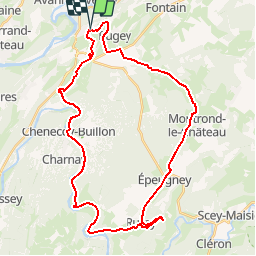
Trail Mountain bike of 38 km to be discovered at Bourgogne-Franche-Comté, Doubs, Larnod. This trail is proposed by tracegps.

Description

Ce parcours traverse les villages de Larnod, Pugey, Montrond le chateau, Epeugney, Rurey et Chenecey-Buillon. Ce circuit n'est pas très difficile techniquement, on retrouve un peu tous types de chemin. La difficulté principale est la longueur qui approche les 40km. Attention à la dernière montée sur la fin du parcours pour rejoindre Larnod, après 35km déjà effectué, c'est dur... Il faut passer sous/sur quelques clôtures électriques à l'approche d'une ferme. On apprécie particulièrement le belvédère de Rurey avec son sentier botanique, l'entrée de l'ancienne Abbaye de Buillon, et au sommet de la montagne, les ruines du château de Chenecey.

Elevation profile

Photos

Positioning

Country:
France
Region :
Bourgogne-Franche-Comté
Department/Province :
Doubs
Municipality :
Larnod
Location:
Unknown
Start:(UTM)
725281 ; 5230326 (31T) N.

Trails nearby

Trail Walking Beure - Beure de la pisseur au mercureau  - Photo
Walking
eltonnermou

Walking

Difficult
(1)
Beure, Bourgogne-Franche-Comté, Doubs, France
16.8 km | 24 km-effort
3h 48min
Yes
Trail Walking Beure -
Walking
eltonnermou

Walking

Medium
(1)
Beure, Bourgogne-Franche-Comté, Doubs, France
15.7 km | 22 km-effort
6h 35min
Yes
Trail Walking Fontain - fontain - fort de Fontain - forêt de Fontain - Photo
Walking
eltonnermou

Walking

Very easy
(1)
Fontain, Bourgogne-Franche-Comté, Doubs, France
10.9 km | 14 km-effort
3h 11min
Yes
Trail On foot Busy - Sentier de la Pierre de Vorges - Photo
On foot
GUIDE+

On foot

Easy
Busy, Bourgogne-Franche-Comté, Doubs, France
7.2 km | 9.4 km-effort
2h 8min
Yes
Trail On foot Vorges-les-Pins - Sentier des Crêtes - Photo
On foot
GUIDE+

On foot

Easy
Vorges-les-Pins, Bourgogne-Franche-Comté, Doubs, France
4.2 km | 6.1 km-effort
1h 23min
Yes
Trail On foot Fontain - Grande Boucle de Fontain - Photo
On foot
GUIDE+

On foot

Easy
Fontain, Bourgogne-Franche-Comté, Doubs, France
10 km | 13.2 km-effort
2h 59min
Yes
Trail On foot Fontain - Sentier des Grands Prés - Photo
On foot
GUIDE+

On foot

Easy
Fontain, Bourgogne-Franche-Comté, Doubs, France
6.6 km | 9.6 km-effort
2h 10min
Yes
Trail On foot Besançon - Circuit de Planoise - Photo
On foot
GUIDE+

On foot

Easy
Besançon, Bourgogne-Franche-Comté, Doubs, France
4.6 km | 7.6 km-effort
1h 43min
Yes
Trail On foot Montferrand-le-Château - Sentier de Crête et Bois Rapin - Photo
On foot
GUIDE+

On foot

Easy
(1)
Montferrand-le-Château, Bourgogne-Franche-Comté, Doubs, France
10.1 km | 14.1 km-effort
3h 11min
Yes


Close
My subscriptions