Trail Mountain bike Besançon - Le Grand Ouest de Besançon - Photo

Le Grand Ouest de Besançon

 tracegps
tracegps

User

© OpenStreetMap contributors
Length
Length
48 km
Max alt
Max alt
321 m
Uphill gradient
Uphill gradient
730 m
Km-Effort
Km-Effort  
58 km
Min alt
Min alt
226 m
Downhill gradient
Downhill gradient
729 m
Boucle
Boucle
Yes
Creation date :
2014-12-10 00:00:00.0
Updated on :
2014-12-10 00:00:00.0

(0 Reviews)

Mountain bike
Mountain bike
4h00
Difficulty : Difficult

Scan this QR Code to open this trail in the SityTrail application

FREE GPS app for hiking

Logo SityTrail SityTrail

IGN / Geographical institutes

Download SityTrail from the App Store Download SityTrail from Google Play

Logo SityTrail SityTrail World

The world is yours!

Download SityTrail from the App Store Download SityTrail from Google Play Download SityTrail on Huawei AppGallery

About

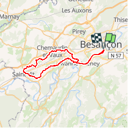
Trail Mountain bike of 48 km to be discovered at Bourgogne-Franche-Comté, Doubs, Besançon. This trail is proposed by tracegps.

Description

Ce parcours est assez long mais assez roulant surtout sur le retour. On passe dans les villages ou à proximité de: Avanne, la Belle Etoile, Grandfontaine, Velesmes Essarts, Routelle, St Vit, Pouilley Francais, Dannemarie, Chemaudin, Franois, Chateaufarine, et retour sur Avanne et Besançon. Les sentiers sont faits de chemins dans les bois, graviers et un peu de goudron également. A la sortie d'Avanne, une bonne montée nous emmène dans les bois pour n'en ressortir quasiment qu’à St Vit. Au retour, on retrouve des chemins en cailloux, des sentiers dans les bois et les liaisons entre les villages sur le goudron.

Elevation profile

Photos

Positioning

Country:
France
Region :
Bourgogne-Franche-Comté
Department/Province :
Doubs
Municipality :
Besançon
Location:
Unknown
Start:(UTM)
275212 ; 5234733 (32T) N.

Trails nearby

Trail Walking Beure - Beure de la pisseur au mercureau  - Photo
Walking
eltonnermou

Walking

Difficult
(1)
Beure, Bourgogne-Franche-Comté, Doubs, France
16.8 km | 24 km-effort
3h 48min
Yes
Trail Walking Beure -
Walking
eltonnermou

Walking

Medium
(1)
Beure, Bourgogne-Franche-Comté, Doubs, France
15.7 km | 22 km-effort
6h 35min
Yes
Trail Walking Montfaucon - Du chateau au fort de Monfaucon - Photo
Walking
yew

Walking

Easy
(1)
Montfaucon, Bourgogne-Franche-Comté, Doubs, France
6.9 km | 9.3 km-effort
1h 55min
Yes
Trail Walking Besançon - Colline de Besançon 29-08-2020 - Photo
Walking
legios84

Walking

Medium
(1)
Besançon, Bourgogne-Franche-Comté, Doubs, France
13.4 km | 17.7 km-effort
2h 46min
Yes
Trail Walking Fontain - fontain - fort de Fontain - forêt de Fontain - Photo
Walking
eltonnermou

Walking

Very easy
(1)
Fontain, Bourgogne-Franche-Comté, Doubs, France
10.9 km | 14 km-effort
3h 11min
Yes
Trail On foot Montfaucon - Boucle de Nacra - Photo
On foot
GUIDE+

On foot

Easy
Montfaucon, Bourgogne-Franche-Comté, Doubs, France
3 km | 4.4 km-effort
1h 0min
Yes
Trail On foot Montfaucon - Sentier des Falaises et du château - Photo
On foot
GUIDE+

On foot

Easy
Montfaucon, Bourgogne-Franche-Comté, Doubs, France
5 km | 7.1 km-effort
1h 37min
Yes
Trail On foot Montfaucon - Sentier du Fort et des Batteries - Photo
On foot
GUIDE+

On foot

Easy
Montfaucon, Bourgogne-Franche-Comté, Doubs, France
6.6 km | 8.7 km-effort
1h 58min
Yes
Trail On foot Fontain - Grande Boucle de Fontain - Photo
On foot
GUIDE+

On foot

Easy
Fontain, Bourgogne-Franche-Comté, Doubs, France
10 km | 13.2 km-effort
2h 59min
Yes


Close
My subscriptions