Trail Mountain bike Lussan - Randonnée VTT Lussan - Photo

Randonnée VTT Lussan

 tracegps
tracegps

User

© OpenStreetMap contributors
Length
Length
42 km
Max alt
Max alt
344 m
Uphill gradient
Uphill gradient
752 m
Km-Effort
Km-Effort  
52 km
Min alt
Min alt
226 m
Downhill gradient
Downhill gradient
753 m
Boucle
Boucle
Yes
Creation date :
2014-12-10 00:00:00.0
Updated on :
2014-12-10 00:00:00.0

(0 Reviews)

Mountain bike
Mountain bike
3h30
Difficulty : Difficult

Scan this QR Code to open this trail in the SityTrail application

FREE GPS app for hiking

Logo SityTrail SityTrail

IGN / Geographical institutes

Download SityTrail from the App Store Download SityTrail from Google Play

Logo SityTrail SityTrail World

The world is yours!

Download SityTrail from the App Store Download SityTrail from Google Play Download SityTrail on Huawei AppGallery

About

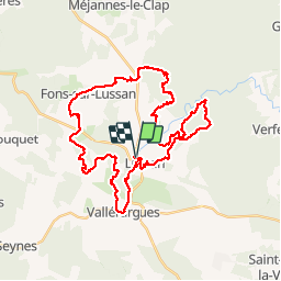
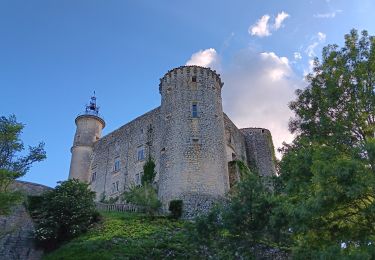
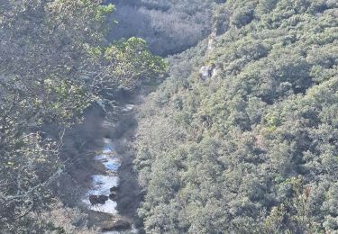
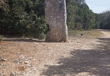
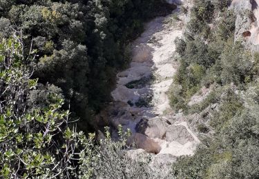
Trail Mountain bike of 42 km to be discovered at Occitania, Gard, Lussan. This trail is proposed by tracegps.

Description

Randonnée VTT de Lussan, date 17 mai 2009, 45 kilomètres, 937 altimètre !

Elevation profile

Points of interest

Point of interest Cavillargues - 238 METER - Photo
tracegps
CAVILLARGUES 
Point of interest Argilliers - ARGILLIERS - Photo
tracegps
ARGILLIERS 
Point of interest Lussan - Arrivée - Photo
tracegps
LUSSAN 
Point of interest Bagnols-sur-Cèze - BAGNOLS-SU - Photo
tracegps
BAGNOLS-SUR-CÈZE 
Point of interest Bédoin - BDOIN - Photo
tracegps
BÉDOIN 
Point of interest Bédoin - BDOIN 1 - Photo
tracegps
BÉDOIN 
Point of interest Sabran - BEGIN - EI - Photo
tracegps
SABRAN 
Point of interest Pougnadoresse - BEGIN SHOR - Photo
tracegps
POUGNADORESSE 
Point of interest Sabran - BOUSSARGUE - Photo
tracegps
SABRAN 
Point of interest Sabran - CADIGNAC - Photo
tracegps
SABRAN 
Point of interest Sabran - CARME - Photo
tracegps
SABRAN 
Point of interest Cavillargues - CAVILLARGU - Photo
tracegps
CAVILLARGUES 
Point of interest La Bastide-d'Engras - CHAPELLE S - Photo
tracegps
LA BASTIDE-D'ENGRAS 
Point of interest Sabran - CHARAVEL - Photo
tracegps
SABRAN 
Point of interest Sabran - COLOMBIER - Photo
tracegps
SABRAN 
Point of interest Sabran - COMBE - Photo
tracegps
SABRAN 
Point of interest Connaux - CONNAUX - Photo
tracegps
CONNAUX 
Point of interest Croix-en-Ternois - CROIX-EN-T - Photo
tracegps
CROIX-EN-TERNOIS 
Point of interest Lussan - Départ TT Lusan - Photo
tracegps
Point of interest Lussan - direction - Photo
tracegps
LUSSAN 
Point of interest Sabran - DONNAT - Photo
tracegps
SABRAN 
Point of interest Flaux - FLAUX - Photo
tracegps
FLAUX 
Point of interest Fontarèches - FONTARCHES - Photo
tracegps
FONTARÈCHES 
Point of interest Gaujac - GAUJAC - Photo
tracegps
GAUJAC 
Point of interest La Bastide-d'Engras - LA BASTIDE - Photo
tracegps
LA BASTIDE-D'ENGRAS 
Point of interest La Bruguière - LA BRUGUIR - Photo
tracegps
LA BRUGUIÈRE 
Point of interest La Capelle-et-Masmolène - LA CAPELLE - Photo
tracegps
LA CAPELLE-ET-MASMOLÈNE 
Point of interest La Roque-sur-Cèze - LA ROQUE-S - Photo
tracegps
LA ROQUE-SUR-CÈZE 
Point of interest Sabran - LA VALLONN - Photo
tracegps
SABRAN 
Point of interest Welkenraedt - LANTZE - Photo
tracegps
WELKENRAEDT 
Point of interest Le Pin - LE PIN - Photo
tracegps
LE PIN 
Point of interest Malaucène - MALAUCNE - Photo
tracegps
MALAUCÈNE 
Point of interest Malaucène - MALAUCNE 1 - Photo
tracegps
MALAUCÈNE 
Point of interest La Capelle-et-Masmolène - MASMOLNE - Photo
tracegps
LA CAPELLE-ET-MASMOLÈNE 
Point of interest Sabran - MGIERS - Photo
tracegps
SABRAN 
Point of interest Saint-Hippolyte-de-Montaigu - MONT AIGU - Photo
tracegps
SAINT-HIPPOLYTE-DE-MONTAIGU 
Point of interest Brouzet-lès-Alès - MONT BOUQU - Photo
tracegps
BROUZET-LÈS-ALÈS 
Point of interest Beaumont-du-Ventoux - MONT VENTO - Photo
tracegps
BEAUMONT-DU-VENTOUX 
Point of interest Sabran - PAD - Photo
tracegps
SABRAN 
Point of interest Pougnadoresse - POUGNADORE - Photo
tracegps
POUGNADORESSE 
Point of interest Sabran - RATACAN - Photo
tracegps
SABRAN 
Point of interest Sabran - REMJEANNE - Photo
tracegps
SABRAN 
Point of interest Sabran - SABRAN - Photo
tracegps
SABRAN 
Point of interest Saint-André-d'Olérargues - SAINT-ANDR - Photo
tracegps
SAINT-ANDRÉ-D'OLÉRARGUES 
Point of interest Saint-Gervais - SAINT-GERV - Photo
tracegps
SAINT-GERVAIS 
Point of interest Saint-Hilaire-d'Ozilhan - SAINT-HILA - Photo
tracegps
SAINT-HILAIRE-D'OZILHAN 
Point of interest Saint-Hippolyte-de-Montaigu - SAINT-HIPP - Photo
tracegps
SAINT-HIPPOLYTE-DE-MONTAIGU 
Point of interest Saint-Laurent-la-Vernède - SAINT-LAUR - Photo
tracegps
SAINT-LAURENT-LA-VERNÈDE 
Point of interest Saint-Marcel-de-Careiret - SAINT-MARC - Photo
tracegps
SAINT-MARCEL-DE-CAREIRET 
Point of interest Saint-Maximin - SAINT-MAXI - Photo
tracegps
SAINT-MAXIMIN 
Point of interest Saint-Pol-sur-Ternoise - SAINT-POL - Photo
tracegps
SAINT-POL-SUR-TERNOISE 
Point of interest Saint-Pons-la-Calm - SAINT-PONS - Photo
tracegps
SAINT-PONS-LA-CALM 
Point of interest Saint-Quentin-la-Poterie - SAINT-QUEN - Photo
tracegps
SAINT-QUENTIN-LA-POTERIE 
Point of interest Saint-Victor-des-Oules - SAINT-VICT - Photo
tracegps
SAINT-VICTOR-DES-OULES 
Point of interest Sault - SAULT - Photo
tracegps
SAULT 
Point of interest Sabran - SHORTCUT - Photo
tracegps
SABRAN 
Point of interest Sabran - SHORTCUT C - Photo
tracegps
SABRAN 
Point of interest Sabran - SHORTCUT1 - Photo
tracegps
SABRAN 
Point of interest Pougnadoresse - SHORTCUT2 - Photo
tracegps
POUGNADORESSE 
Point of interest Pougnadoresse - SHORTCUT3 - Photo
tracegps
POUGNADORESSE 
Point of interest Le Pin - SHORTCUT4 - Photo
tracegps
LE PIN 
Point of interest Eijsden-Margraten - SINTGE - Photo
tracegps
EIJSDEN-MARGRATEN 
Point of interest Baron - TARDRE - Photo
tracegps
BARON 
Point of interest Sabran - TT6 - Photo
tracegps
SABRAN 
Point of interest Sabran - TT7 - Photo
tracegps
SABRAN 
Point of interest Sabran - TT8 - Photo
tracegps
SABRAN 
Point of interest Sabran - TT9 - Photo
tracegps
SABRAN 
Point of interest Uzès - UZS - Photo
tracegps
UZÈS 
Point of interest Vallabrix - VALLABRIX - Photo
tracegps
VALLABRIX 
Point of interest Valliguières - VALLIGUIRE - Photo
tracegps
VALLIGUIÈRES 
Point of interest Verfeuil - VERFEUIL - Photo
tracegps
VERFEUIL 

Positioning

Country:
France
Region :
Occitania
Department/Province :
Gard
Municipality :
Lussan
Location:
Unknown
Start:(Dec)
Start:(UTM)
608766 ; 4890147 (31T) N.

Trails nearby

Trail Walking Lussan - 30 les concluses - Photo
Walking
GUIDE
randodyssée

Walking

Easy
(1)
Lussan, Occitania, Gard, France
8 km | 11.1 km-effort
2h 24min
No
Trail Walking Lussan - 30 conclused - Photo
Walking
GUIDE
randodyssée

Walking

Difficult
Lussan, Occitania, Gard, France
14.3 km | 19.6 km-effort
7h 57min
Yes
Trail Walking Lussan - Concluses de Lussan - Photo
Walking
GUIDE
nadinebondoux

Walking

Difficult
Lussan, Occitania, Gard, France
26 km | 0 m-effort
5h 46min
No
Trail Walking Lussan - LUSSAN - LES CONCLUSES - 11.3 Km - 3h30 - Dénivelé 170 m  - Photo
Walking
dansmabulle

Walking

Difficult
(2)
Lussan, Occitania, Gard, France
11.3 km | 15 km-effort
3h 21min
Yes
Trail Walking Lussan - de Lussan aux Concluses - Photo
Walking
GUIDE
stef789

Walking

Medium
Lussan, Occitania, Gard, France
15.8 km | 20 km-effort
5h 41min
Yes
Trail Walking Lussan - de Prades au Concluses - Photo
Walking
GUIDE
nadinebondoux

Walking

Medium
Lussan, Occitania, Gard, France
9.6 km | 12.9 km-effort
2h 48min
Yes
Trail Walking Lussan - randonnée Prades les concluses  - Photo
Walking
bidetarou

Walking

Medium
Lussan, Occitania, Gard, France
11 km | 15.6 km-effort
3h 50min
Yes
Trail Walking Lussan - LUSSAN (30)   Baume des Boeufs - Photo
Walking
Manoune

Walking

Medium
Lussan, Occitania, Gard, France
16.7 km | 21 km-effort
5h 39min
Yes
Trail Walking Fons-sur-Lussan - Serre de Fons - Photo
Walking
xmayeur

Walking

Medium
Fons-sur-Lussan, Occitania, Gard, France
4.7 km | 6.7 km-effort
1h 39min
No


Close
My subscriptions