![](/images/other/stat-length.png)
![Trail Walking Vollore-Ville - Le Grun de Chignore court - Photo](https://media.geolcdn.com/t/1900/400/ext.pjpeg?maxdim=2&url=https%3A%2F%2Fstatic1.geolcdn.com%2Fsiteimages%2Fupload%2Ffiles%2F1553511878bg_sport_marche.png)
Le Grun de Chignore court
tracegps
User
![Length](/images/other/stat-length.png)
![Max alt](https://static1.geolcdn.com/siteimages/upload/files/1508320355ic_sort_altitude_max_24dp.png)
![Uphill gradient](https://static1.geolcdn.com/siteimages/upload/files/1508320355ic_sort_den_pos_24dp.png)
![Km-Effort](/images/other/stat-length.png)
![Min alt](https://static1.geolcdn.com/siteimages/upload/files/1508320355ic_sort_altitude_min_24dp.png)
![Downhill gradient](https://static1.geolcdn.com/siteimages/upload/files/1508320355ic_sort_den_neg_24dp.png)
![Boucle](https://static1.geolcdn.com/siteimages/upload/files/16400158638029165_repeat_loop_refresh_sync_direction_icon.png)
![Walking](https://static1.geolcdn.com/sitytour/trail-icons/101.png)
3h00
Difficulty : Difficult
![Scan this QR Code to open this trail in the SityTrail application](https://capi.geolives.com/qq0zvz2zws4bq2lad0pu/sitytour/trails/103428/qr.png?size=200)
FREE GPS app for hiking
About
Trail Walking of 11.4 km to be discovered at Auvergne-Rhône-Alpes, Puy-de-Dôme, Vollore-Ville. This trail is proposed by tracegps.
Description
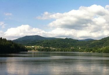
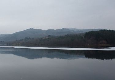
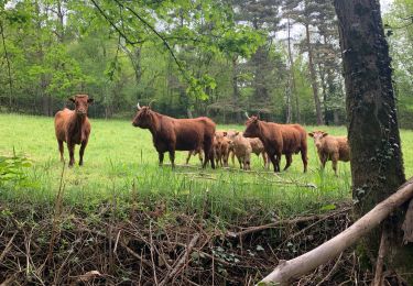
Rando dans les Monts du Forez sur les flancs du Grun de Chignore. Le départ se situe devant le camping de Vollore-ville. La montée emprunte de bons chemins à travers prés et forêts. Les chemins sont pavés par endroit, deviennent sentiers, sautent un ruisseau ou traversent un éboulis. En prenant de l'altitude, la forêt se densifie et l'on peut voir à l'horizon, à travers les trouées, la chaine des Puys à quelques 100 km de là. On entre dans la forêt d'Ayguebonne avant d'entamer la descente. Celle-ci est assez difficile car très caillouteuse et rapide (on passe de 900m à 520m en 2km). C'est une belle rando dans une nature restée sauvage, où l'on a pu apercevoir quelques animaux (écureuil, sanglier, chevreuil)en fin de journée.
Positioning
Comments
Trails nearby
![Trail Walking Aubusson-d'Auvergne - Aubusson_Lac - Photo](https://media.geolcdn.com/t/375/260/e8789334-900b-4b7b-aeae-be52f5c8b304.jpg&format=jpg&maxdim=2)
![Walking Walking](https://static1.geolcdn.com/sitytour/trail-icons/101.png)
Walking
![](/images/other/stat-length.png)
![](https://static1.geolcdn.com/siteimages/upload/files/16400158638029165_repeat_loop_refresh_sync_direction_icon.png)
![Trail Walking Courpière - Les Taillades près Courpière - Photo](https://media.geolcdn.com/t/375/260/ext.jpg?maxdim=2&url=https%3A%2F%2Fservices.sitytrail.com%2FGeolivesWS%2FDownloadMedia.ashx%3FTrailID%3D105959%26Media%3D10032_1.jpg)
![Walking Walking](https://static1.geolcdn.com/sitytour/trail-icons/101.png)
Walking
![](/images/other/stat-length.png)
![](https://static1.geolcdn.com/siteimages/upload/files/16400158638029165_repeat_loop_refresh_sync_direction_icon.png)
![Trail On foot Vollore-Ville - Le Grun de Chignore - Photo](https://media.geolcdn.com/t/375/260/d670d619-94c1-4ebf-b98b-e05e4075dc52.jpeg&format=jpg&maxdim=2)
![On foot On foot](https://static1.geolcdn.com/sitytour/trail-icons/100.png)
On foot
![](/images/other/stat-length.png)
![](https://static1.geolcdn.com/siteimages/upload/files/16400158638029165_repeat_loop_refresh_sync_direction_icon.png)
![Trail Walking Sainte-Agathe - Ste_Agathe_Peage - Photo](https://media.geolcdn.com/t/375/260/ae73d591-dc6d-481d-b0b0-e0d1ded3bb7c.jpg&format=jpg&maxdim=2)
![Walking Walking](https://static1.geolcdn.com/sitytour/trail-icons/101.png)
Walking
![](/images/other/stat-length.png)
![](https://static1.geolcdn.com/siteimages/upload/files/16400158638029165_repeat_loop_refresh_sync_direction_icon.png)
![Trail Walking Aubusson-d'Auvergne - Courpiere_Salet - Photo](https://media.geolcdn.com/t/375/260/bbf55bae-e8c1-4a54-bc8e-1404647a3e82.jpg&format=jpg&maxdim=2)
![Walking Walking](https://static1.geolcdn.com/sitytour/trail-icons/101.png)
Walking
![](/images/other/stat-length.png)
![](https://static1.geolcdn.com/siteimages/upload/files/16400158638029165_repeat_loop_refresh_sync_direction_icon.png)
![Trail sport Courpière - COURPIERE Auvergne - Photo](https://media.geolcdn.com/t/375/260/998a6c45-edc4-4a49-93a0-d1f6173e4780.jpg&format=jpg&maxdim=2)
sport
![](/images/other/stat-length.png)
![](https://static1.geolcdn.com/siteimages/upload/files/16400158638029165_repeat_loop_refresh_sync_direction_icon.png)
![Trail Walking Sainte-Agathe - Saint agate 3ieme jour - Photo](https://media.geolcdn.com/t/375/260/339ddc93-a3ab-4bd3-b422-9ab8f5ca89f2.jpg&format=jpg&maxdim=2)
![Walking Walking](https://static1.geolcdn.com/sitytour/trail-icons/101.png)
Walking
![](/images/other/stat-length.png)
![](https://static1.geolcdn.com/siteimages/upload/files/16400158638029165_repeat_loop_refresh_sync_direction_icon.png)
![Trail Walking Aubusson-d'Auvergne - Les quatre vents Aubusson 1er jour - Photo](https://media.geolcdn.com/t/375/260/76dd7eb9-eaaa-4c14-b581-8d417a1c9807.jpg&format=jpg&maxdim=2)
![Walking Walking](https://static1.geolcdn.com/sitytour/trail-icons/101.png)
Walking
![](/images/other/stat-length.png)
![](https://static1.geolcdn.com/siteimages/upload/files/16400158638029165_repeat_loop_refresh_sync_direction_icon.png)
![Trail On foot Sainte-Agathe - Le Peage - Photo](https://media.geolcdn.com/t/375/260/ext.jpg?maxdim=2&url=https%3A%2F%2Fstatic1.geolcdn.com%2Fsiteimages%2Fupload%2Ffiles%2F1545311037marcheuse_200dpi.jpg)
![On foot On foot](https://static1.geolcdn.com/sitytour/trail-icons/100.png)
On foot
![](/images/other/stat-length.png)
![](https://static1.geolcdn.com/siteimages/upload/files/16400158638029165_repeat_loop_refresh_sync_direction_icon.png)