![](/images/other/stat-length.png)
![Trail Mountain bike Villard-de-Lans - vallée méaudret - Photo](https://media.geolcdn.com/t/1900/400/ext.pjpeg?maxdim=2&url=https%3A%2F%2Fstatic1.geolcdn.com%2Fsiteimages%2Fupload%2Ffiles%2F1524743154velo.jpg)
vallée méaudret
Baroux
User
![Length](/images/other/stat-length.png)
Length
9 km
![Max alt](https://static1.geolcdn.com/siteimages/upload/files/1508320355ic_sort_altitude_max_24dp.png)
Max alt
998 m
![Uphill gradient](https://static1.geolcdn.com/siteimages/upload/files/1508320355ic_sort_den_pos_24dp.png)
Uphill gradient
186 m
![Km-Effort](/images/other/stat-length.png)
Km-Effort
11.5 km
![Min alt](https://static1.geolcdn.com/siteimages/upload/files/1508320355ic_sort_altitude_min_24dp.png)
Min alt
930 m
![Downhill gradient](https://static1.geolcdn.com/siteimages/upload/files/1508320355ic_sort_den_neg_24dp.png)
Downhill gradient
209 m
![Boucle](https://static1.geolcdn.com/siteimages/upload/files/16400158638029165_repeat_loop_refresh_sync_direction_icon.png)
Boucle
No
Creation date :
2019-01-15 15:43:35.569
Updated on :
2019-01-15 15:43:35.569
![Mountain bike](https://static1.geolcdn.com/sitytour/trail-icons/202.png)
45m
Difficulty : Medium
![Scan this QR Code to open this trail in the SityTrail application](https://capi.geolives.com/qq0zvz2zws4bq2lad0pu/sitytour/trails/1033761/qr.png?size=200)
FREE GPS app for hiking
About
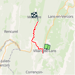
Trail Mountain bike of 9 km to be discovered at Auvergne-Rhône-Alpes, Isère, Villard-de-Lans. This trail is proposed by Baroux.
Description
Départ de Villard de Lans (Essarton) pour rejoindre la boucle Méaudre Autrans vers les Girauds.
Bel itinéraire aux aménagements superbes
Positioning
Country:
France
Region :
Auvergne-Rhône-Alpes
Department/Province :
Isère
Municipality :
Villard-de-Lans
Location:
Unknown
Start:(Dec)
Start:(UTM)
700629 ; 4993501 (31T) N.
Comments
Trails nearby
![Trail Walking Lans-en-Vercors - 38 pic st michel - Photo](https://media.geolcdn.com/t/375/260/cfeb7787-6d5b-45db-91c6-1feb93d2f73c.jpg&format=jpg&maxdim=2)
![Walking Walking](https://static1.geolcdn.com/sitytour/trail-icons/101.png)
38 pic st michel
Walking
Easy
(1)
Lans-en-Vercors,
Auvergne-Rhône-Alpes,
Isère,
France
![](/images/other/stat-length.png)
8.7 km | 17.3 km-effort
5h 16min
![](https://static1.geolcdn.com/siteimages/upload/files/16400158638029165_repeat_loop_refresh_sync_direction_icon.png)
Yes
![Trail Walking Villard-de-Lans - villard col des 2 soeurs - Photo](https://media.geolcdn.com/t/375/260/ext.jpg?maxdim=2&url=https%3A%2F%2Fservices.sitytrail.com%2FGeolivesWS%2FDownloadMedia.ashx%3FTrailID%3D453991%26Media%3Dfix__20150803124330.jpg)
![Walking Walking](https://static1.geolcdn.com/sitytour/trail-icons/101.png)
villard col des 2 soeurs
Walking
Medium
(1)
Villard-de-Lans,
Auvergne-Rhône-Alpes,
Isère,
France
![](/images/other/stat-length.png)
7.7 km | 13.8 km-effort
2h 45min
![](https://static1.geolcdn.com/siteimages/upload/files/16400158638029165_repeat_loop_refresh_sync_direction_icon.png)
Yes
![Trail Snowshoes Autrans-Méaudre en Vercors - Le Gros Martel - Méaudre - Photo](https://media.geolcdn.com/t/375/260/ext.jpg?maxdim=2&url=https%3A%2F%2Fservices.sitytrail.com%2FGeolivesWS%2FDownloadMedia.ashx%3FTrailID%3D191341%26Media%3D14899_5.jpg)
![Snowshoes Snowshoes](https://static1.geolcdn.com/sitytour/trail-icons/504.png)
Le Gros Martel - Méaudre
Snowshoes
Medium
(4)
Autrans-Méaudre en Vercors,
Auvergne-Rhône-Alpes,
Isère,
France
![](/images/other/stat-length.png)
4.9 km | 8.4 km-effort
2h 10min
![](https://static1.geolcdn.com/siteimages/upload/files/16400158638029165_repeat_loop_refresh_sync_direction_icon.png)
Yes
![Trail Walking Villard-de-Lans - cabane de robon - Photo](https://media.geolcdn.com/t/375/260/f81b29b4-5a6d-4db9-85aa-f42275b30a70.jpg&format=jpg&maxdim=2)
![Walking Walking](https://static1.geolcdn.com/sitytour/trail-icons/101.png)
cabane de robon
Walking
Very easy
(1)
Villard-de-Lans,
Auvergne-Rhône-Alpes,
Isère,
France
![](/images/other/stat-length.png)
10.2 km | 15.8 km-effort
5h 25min
![](https://static1.geolcdn.com/siteimages/upload/files/16400158638029165_repeat_loop_refresh_sync_direction_icon.png)
Yes
![Trail Snowshoes Lans-en-Vercors - Le Pic Saint-Michel en raquettes (2012) - Photo](https://media.geolcdn.com/t/375/260/ext.jpg?maxdim=2&url=https%3A%2F%2Fservices.sitytrail.com%2FGeolivesWS%2FDownloadMedia.ashx%3FTrailID%3D107676%26Media%3D12680_1.jpg)
![Snowshoes Snowshoes](https://static1.geolcdn.com/sitytour/trail-icons/504.png)
Le Pic Saint-Michel en raquettes (2012)
Snowshoes
Medium
(2)
Lans-en-Vercors,
Auvergne-Rhône-Alpes,
Isère,
France
![](/images/other/stat-length.png)
8.4 km | 17.3 km-effort
5h 0min
![](https://static1.geolcdn.com/siteimages/upload/files/16400158638029165_repeat_loop_refresh_sync_direction_icon.png)
Yes
![Trail Mountain bike Corrençon-en-Vercors - Grande Traversée des PréAlpes à VTT : Corrençon en Vercors - La Chapelle en Vercors - Photo](https://media.geolcdn.com/t/375/260/ext.jpg?maxdim=2&url=https%3A%2F%2Fservices.sitytrail.com%2FGeolivesWS%2FDownloadMedia.ashx%3FTrailID%3D102135%26Media%3D2525_2.jpg)
![Mountain bike Mountain bike](https://static1.geolcdn.com/sitytour/trail-icons/202.png)
Grande Traversée des PréAlpes à VTT : Corrençon en Vercors - La Chapelle en V...
Mountain bike
Difficult
(1)
Corrençon-en-Vercors,
Auvergne-Rhône-Alpes,
Isère,
France
![](/images/other/stat-length.png)
25 km | 36 km-effort
3h 30min
![](https://static1.geolcdn.com/siteimages/upload/files/16400158638029165_repeat_loop_refresh_sync_direction_icon.png)
No
![Trail Walking Villard-de-Lans - Le sentier Peronnard et le Pas de l'OEille - Photo](https://media.geolcdn.com/t/375/260/ext.jpg?maxdim=2&url=https%3A%2F%2Fservices.sitytrail.com%2FGeolivesWS%2FDownloadMedia.ashx%3FTrailID%3D101509%26Media%3D1614_1.jpg)
![Walking Walking](https://static1.geolcdn.com/sitytour/trail-icons/101.png)
Le sentier Peronnard et le Pas de l'OEille
Walking
Easy
(1)
Villard-de-Lans,
Auvergne-Rhône-Alpes,
Isère,
France
![](/images/other/stat-length.png)
13.7 km | 25 km-effort
6h 0min
![](https://static1.geolcdn.com/siteimages/upload/files/16400158638029165_repeat_loop_refresh_sync_direction_icon.png)
Yes
![Trail Walking Villard-de-Lans - Le Plateau du Cornafion 1906m - Photo](https://media.geolcdn.com/t/375/260/ext.jpg?maxdim=2&url=https%3A%2F%2Fservices.sitytrail.com%2FGeolivesWS%2FDownloadMedia.ashx%3FTrailID%3D101491%26Media%3D1596_1.jpg)
![Walking Walking](https://static1.geolcdn.com/sitytour/trail-icons/101.png)
Le Plateau du Cornafion 1906m
Walking
Difficult
(1)
Villard-de-Lans,
Auvergne-Rhône-Alpes,
Isère,
France
![](/images/other/stat-length.png)
7.8 km | 17.7 km-effort
4h 30min
![](https://static1.geolcdn.com/siteimages/upload/files/16400158638029165_repeat_loop_refresh_sync_direction_icon.png)
Yes
![Trail Walking Villard-de-Lans - lac de Moucherolle par les liapaz - Photo](https://media.geolcdn.com/t/375/260/f566df8e-f7a1-49c6-82b0-31013bff1844.jpg&format=jpg&maxdim=2)
![Walking Walking](https://static1.geolcdn.com/sitytour/trail-icons/101.png)
lac de Moucherolle par les liapaz
Walking
Difficult
Villard-de-Lans,
Auvergne-Rhône-Alpes,
Isère,
France
![](/images/other/stat-length.png)
7.2 km | 12.9 km-effort
3h 11min
![](https://static1.geolcdn.com/siteimages/upload/files/16400158638029165_repeat_loop_refresh_sync_direction_icon.png)
Yes