Trail Walking Lagny - Rando VTT Lagny 2009 - Photo

Rando VTT Lagny 2009

 tracegps
tracegps

User

© OpenStreetMap contributors
Length
Length
44 km
Max alt
Max alt
179 m
Uphill gradient
Uphill gradient
746 m
Km-Effort
Km-Effort  
54 km
Min alt
Min alt
48 m
Downhill gradient
Downhill gradient
748 m
Boucle
Boucle
Yes
Creation date :
2014-12-10 00:00:00.0
Updated on :
2014-12-10 00:00:00.0

(0 Reviews)

Walking
Walking
8h00
Difficulty : Very difficult

Scan this QR Code to open this trail in the SityTrail application

FREE GPS app for hiking

Logo SityTrail SityTrail

IGN / Geographical institutes

Download SityTrail from the App Store Download SityTrail from Google Play

Logo SityTrail SityTrail World

The world is yours!

Download SityTrail from the App Store Download SityTrail from Google Play Download SityTrail on Huawei AppGallery

About

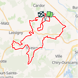
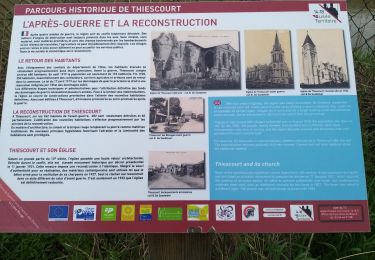
Trail Walking of 44 km to be discovered at Hauts-de-France, Oise, Lagny. This trail is proposed by tracegps.

Description

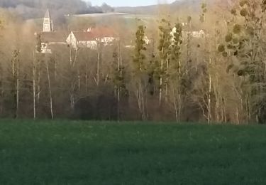
Venez découvrir la belle région de Lassigny et ses environs : le Plémont, l'Ecouvillon, la Chapelle Saint Aubin....

Elevation profile

Positioning

Country:
France
Region :
Hauts-de-France
Department/Province :
Oise
Municipality :
Lagny
Location:
Unknown
Start:(UTM)
493507 ; 5494696 (31U) N.

Trails nearby

Trail Walking Thiescourt - thiescourt fontaine des loups a/r - Photo
Walking
NESTOR2714

Walking

Easy
Thiescourt, Hauts-de-France, Oise, France
4.8 km | 5.5 km-effort
1h 10min
Yes
Trail Walking Larbroye - Circuit des Pierres Sacrées - Larbroye - Photo
Walking
fitz2014

Walking

Medium
(1)
Larbroye, Hauts-de-France, Oise, France
9.6 km | 12.5 km-effort
2h 25min
Yes
Trail Equestrian Thiescourt - Circuit de Thiescourt - Photo
Equestrian
tracegps

Equestrian

Medium
(1)
Thiescourt, Hauts-de-France, Oise, France
8.6 km | 10.7 km-effort
1h 19min
Yes
Trail Mountain bike Thiescourt - Circuit de Thiescourt - Photo
Mountain bike
tracegps

Mountain bike

Medium
Thiescourt, Hauts-de-France, Oise, France
8.6 km | 10.7 km-effort
1h 0min
Yes
Trail Walking Thiescourt - Circuit de Thiescourt - Photo
Walking
tracegps

Walking

Medium
(1)
Thiescourt, Hauts-de-France, Oise, France
8.6 km | 10.7 km-effort
2h 30min
Yes
Trail Walking Larbroye - Circuit des Pierres Sacrées - Larbroye - Photo
Walking
tracegps

Walking

Medium
Larbroye, Hauts-de-France, Oise, France
9.6 km | 12.5 km-effort
2h 25min
Yes
Trail Walking Lassigny - parcours sportif lassigny  - Photo
Walking
NESTOR2714

Walking

Easy
Lassigny, Hauts-de-France, Oise, France
4 km | 4.3 km-effort
1h 3min
Yes
Trail Walking Thiescourt - dessus plateau fontaine des loups - Photo
Walking
NESTOR2714

Walking

Very easy
Thiescourt, Hauts-de-France, Oise, France
6.8 km | 8.6 km-effort
2h 9min
Yes
Trail Walking Thiescourt - grand tour de thiescourt - Photo
Walking
NESTOR2714

Walking

Very easy
Thiescourt, Hauts-de-France, Oise, France
8.1 km | 10.1 km-effort
2h 32min
Yes


Close
My subscriptions