![](/images/other/stat-length.png)
![Trail Walking Messanges - Messanges côté forêt - Photo](https://media.geolcdn.com/t/1900/400/ext.pjpeg?maxdim=2&url=https%3A%2F%2Fstatic1.geolcdn.com%2Fsiteimages%2Fupload%2Ffiles%2F1553511878bg_sport_marche.png)
Messanges côté forêt
tracegps
User
![Length](/images/other/stat-length.png)
Length
9.7 km
![Max alt](https://static1.geolcdn.com/siteimages/upload/files/1508320355ic_sort_altitude_max_24dp.png)
Max alt
59 m
![Uphill gradient](https://static1.geolcdn.com/siteimages/upload/files/1508320355ic_sort_den_pos_24dp.png)
Uphill gradient
136 m
![Km-Effort](/images/other/stat-length.png)
Km-Effort
11.5 km
![Min alt](https://static1.geolcdn.com/siteimages/upload/files/1508320355ic_sort_altitude_min_24dp.png)
Min alt
12 m
![Downhill gradient](https://static1.geolcdn.com/siteimages/upload/files/1508320355ic_sort_den_neg_24dp.png)
Downhill gradient
135 m
![Boucle](https://static1.geolcdn.com/siteimages/upload/files/16400158638029165_repeat_loop_refresh_sync_direction_icon.png)
Boucle
Yes
Creation date :
2014-12-10 00:00:00.0
Updated on :
2014-12-10 00:00:00.0
![Walking](https://static1.geolcdn.com/sitytour/trail-icons/101.png)
2h30
Difficulty : Medium
![Scan this QR Code to open this trail in the SityTrail application](https://capi.geolives.com/qq0zvz2zws4bq2lad0pu/sitytour/trails/103298/qr.png?size=200)
FREE GPS app for hiking
About
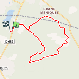
Trail Walking of 9.7 km to be discovered at New Aquitaine, Landes, Messanges. This trail is proposed by tracegps.
Description
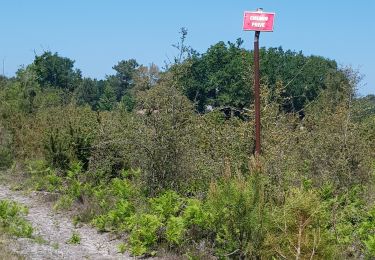
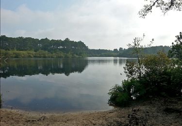
Départ de la ferme équestre de la Prade, à Messanges. Jolie balade dans la forêt landaise où vous pourrez vous apercevoir que les effets de la dernière tempête sont encore visibles. Ça sent bon le pin ! Pas de difficulté particulière.
Positioning
Country:
France
Region :
New Aquitaine
Department/Province :
Landes
Municipality :
Messanges
Location:
Unknown
Start:(Dec)
Start:(UTM)
631093 ; 4854242 (30T) N.
Comments
Trails nearby
![Trail Walking Léon - Etang VSP 10km - Photo](https://media.geolcdn.com/t/375/260/0f991cfe-6bda-4037-a335-2a4be6192310.jpg&format=jpg&maxdim=2)
![Walking Walking](https://static1.geolcdn.com/sitytour/trail-icons/101.png)
Etang VSP 10km
Walking
Easy
(1)
Léon,
New Aquitaine,
Landes,
France
![](/images/other/stat-length.png)
10.2 km | 12.1 km-effort
2h 1min
![](https://static1.geolcdn.com/siteimages/upload/files/16400158638029165_repeat_loop_refresh_sync_direction_icon.png)
Yes
![Trail Mountain bike Vieux-Boucau-les-Bains - Soustons→étang hardy - Photo](https://media.geolcdn.com/t/375/260/ext.jpg?maxdim=2&url=https%3A%2F%2Fstatic1.geolcdn.com%2Fsiteimages%2Fupload%2Ffiles%2F1524743154velo.jpg)
![Mountain bike Mountain bike](https://static1.geolcdn.com/sitytour/trail-icons/202.png)
Soustons→étang hardy
Mountain bike
Medium
(2)
Vieux-Boucau-les-Bains,
New Aquitaine,
Landes,
France
![](/images/other/stat-length.png)
42 km | 48 km-effort
3h 21min
![](https://static1.geolcdn.com/siteimages/upload/files/16400158638029165_repeat_loop_refresh_sync_direction_icon.png)
Yes
![Trail Walking Léon - Courant du Huchet - Photo](https://media.geolcdn.com/t/375/260/32dab752-80e3-43c9-adcf-46932eefb47e.jpg&format=jpg&maxdim=2)
![Walking Walking](https://static1.geolcdn.com/sitytour/trail-icons/101.png)
Courant du Huchet
Walking
Very easy
Léon,
New Aquitaine,
Landes,
France
![](/images/other/stat-length.png)
18.6 km | 21 km-effort
5h 30min
![](https://static1.geolcdn.com/siteimages/upload/files/16400158638029165_repeat_loop_refresh_sync_direction_icon.png)
No
![Trail Walking Moliets-et-Maâ - circuit des Cigales camping au courant d'Uchet et retour - Photo](https://media.geolcdn.com/t/375/260/cb479472-290b-4db1-bc86-532d9c3e1638.jpg&format=jpg&maxdim=2)
![Walking Walking](https://static1.geolcdn.com/sitytour/trail-icons/101.png)
circuit des Cigales camping au courant d'Uchet et retour
Walking
Easy
Moliets-et-Maâ,
New Aquitaine,
Landes,
France
![](/images/other/stat-length.png)
6.5 km | 7.2 km-effort
1h 46min
![](https://static1.geolcdn.com/siteimages/upload/files/16400158638029165_repeat_loop_refresh_sync_direction_icon.png)
Yes
![Trail Walking Vieux-Boucau-les-Bains - vieux boucau golf - Photo](https://media.geolcdn.com/t/375/260/ext.jpg?maxdim=2&url=https%3A%2F%2Fstatic1.geolcdn.com%2Fsiteimages%2Fupload%2Ffiles%2F1553511878bg_sport_marche.png)
![Walking Walking](https://static1.geolcdn.com/sitytour/trail-icons/101.png)
vieux boucau golf
Walking
Very easy
(2)
Vieux-Boucau-les-Bains,
New Aquitaine,
Landes,
France
![](/images/other/stat-length.png)
8 km | 8.7 km-effort
2h 12min
![](https://static1.geolcdn.com/siteimages/upload/files/16400158638029165_repeat_loop_refresh_sync_direction_icon.png)
Yes
![Trail Walking Moliets-et-Maâ - Le Courant d' Huchet _ 5,3 km_Trace GPS - Photo](https://media.geolcdn.com/t/375/260/ext.jpg?maxdim=2&url=https%3A%2F%2Fservices.sitytrail.com%2FGeolivesWS%2FDownloadMedia.ashx%3FTrailID%3D221866%26Media%3D358f56fb-4383-43a9-84d6-d433489d3737.jpg)
![Walking Walking](https://static1.geolcdn.com/sitytour/trail-icons/101.png)
Le Courant d' Huchet _ 5,3 km_Trace GPS
Walking
Very easy
Moliets-et-Maâ,
New Aquitaine,
Landes,
France
![](/images/other/stat-length.png)
5.3 km | 6.1 km-effort
1h 18min
![](https://static1.geolcdn.com/siteimages/upload/files/16400158638029165_repeat_loop_refresh_sync_direction_icon.png)
Yes
![Trail Walking Moliets-et-Maâ - La Chapelle Saint Laurent de Maa _ 8,5 km_Trace GPS - Photo](https://media.geolcdn.com/t/375/260/ext.jpg?maxdim=2&url=https%3A%2F%2Fservices.sitytrail.com%2FGeolivesWS%2FDownloadMedia.ashx%3FTrailID%3D206853%26Media%3D3409a967-a099-4afb-939e-ee94bb6de565.jpg)
![Walking Walking](https://static1.geolcdn.com/sitytour/trail-icons/101.png)
La Chapelle Saint Laurent de Maa _ 8,5 km_Trace GPS
Walking
Easy
Moliets-et-Maâ,
New Aquitaine,
Landes,
France
![](/images/other/stat-length.png)
8.5 km | 9.9 km-effort
2h 2min
![](https://static1.geolcdn.com/siteimages/upload/files/16400158638029165_repeat_loop_refresh_sync_direction_icon.png)
Yes
![Trail Walking Moliets-et-Maâ - Courant Huchet complet - Photo](https://media.geolcdn.com/t/375/260/ext.jpg?maxdim=2&url=https%3A%2F%2Fstatic1.geolcdn.com%2Fsiteimages%2Fupload%2Ffiles%2F1553511878bg_sport_marche.png)
![Walking Walking](https://static1.geolcdn.com/sitytour/trail-icons/101.png)
Courant Huchet complet
Walking
Very easy
(2)
Moliets-et-Maâ,
New Aquitaine,
Landes,
France
![](/images/other/stat-length.png)
15.1 km | 17.4 km-effort
3h 45min
![](https://static1.geolcdn.com/siteimages/upload/files/16400158638029165_repeat_loop_refresh_sync_direction_icon.png)
Yes
![Trail Mountain bike Moliets-et-Maâ - molliet - Photo](https://media.geolcdn.com/t/375/260/ext.jpg?maxdim=2&url=https%3A%2F%2Fservices.sitytrail.com%2FGeolivesWS%2FDownloadMedia.ashx%3FTrailID%3D151568%26Media%3D20120904092515.jpeg)
![Mountain bike Mountain bike](https://static1.geolcdn.com/sitytour/trail-icons/202.png)
molliet
Mountain bike
Very easy
Moliets-et-Maâ,
New Aquitaine,
Landes,
France
![](/images/other/stat-length.png)
8.7 km | 9.7 km-effort
48min
![](https://static1.geolcdn.com/siteimages/upload/files/16400158638029165_repeat_loop_refresh_sync_direction_icon.png)
No