Trail Walking Agos-Vidalos - Le Pibeste par Agos - Photo
 tracegps
tracegps

User

© OpenStreetMap contributors
Length
Length
8.1 km
Max alt
Max alt
1327 m
Uphill gradient
Uphill gradient
962 m
Km-Effort
Km-Effort  
21 km
Min alt
Min alt
454 m
Downhill gradient
Downhill gradient
957 m
Boucle
Boucle
Yes
Creation date :
2014-12-10 00:00:00.0
Updated on :
2014-12-10 00:00:00.0

(0 Reviews)

Walking
Walking
3h30
Difficulty : Difficult

Scan this QR Code to open this trail in the SityTrail application

FREE GPS app for hiking

Logo SityTrail SityTrail

IGN / Geographical institutes

Download SityTrail from the App Store Download SityTrail from Google Play

Logo SityTrail SityTrail World

The world is yours!

Download SityTrail from the App Store Download SityTrail from Google Play Download SityTrail on Huawei AppGallery

About

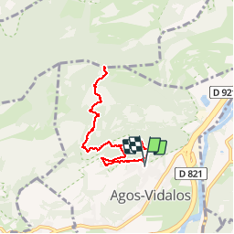
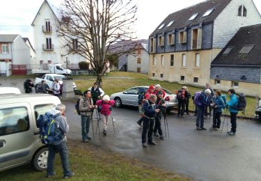
Trail Walking of 8.1 km to be discovered at Occitania, Hautespyrenees, Agos-Vidalos. This trail is proposed by tracegps.

Description

Distance 8.2km Dénivelé 1000m Durée 3h30 A/R On monte généralement au Pibeste par Ouzous et le col de Porte, parfois par Ségus et le mailh d'Arreau. Ce chemin part d'un petit parking au pied de l'église. La montée est régulière et agréable, surtout en été (ombragé). C'est un peu plus dur sur la fin. Il y a une source un peu au dessus de Lascary. C'est toujours très bien indiqué.

Elevation profile

Positioning

Country:
France
Region :
Occitania
Department/Province :
Hautespyrenees
Municipality :
Agos-Vidalos
Location:
Unknown
Start:(UTM)
738425 ; 4769224 (30T) N.

Trails nearby

Trail Walking Argelès-Gazost - Le Mont de Gez en circuit - Argelès Gazost - Photo
Walking
tracegps

Walking

Medium
(1)
Argelès-Gazost, Occitania, Hautespyrenees, France
11.8 km | 20 km-effort
4h 30min
Yes
Trail Electric bike Argelès-Gazost - CABALIROS 30 JUIN 2023 - Photo
Electric bike
GUIDE
harydh

Electric bike

Medium
Argelès-Gazost, Occitania, Hautespyrenees, France
39 km | 57 km-effort
4h 47min
Yes
Trail Walking Argelès-Gazost - ARGELES La boucle de l arrieulat - Photo
Walking
GUIDE
marmotte65

Walking

Difficult
Argelès-Gazost, Occitania, Hautespyrenees, France
10.3 km | 14.6 km-effort
3h 4min
Yes
Trail Walking Ousté - SAINT CRÉAC  le soum de Trémou reco - Photo
Walking
GUIDE
marmotte65

Walking

Difficult
Ousté, Occitania, Hautespyrenees, France
11.2 km | 18.8 km-effort
3h 41min
Yes
Trail Walking Argelès-Gazost - ARGELES-GAZOST chateau et lac d'Arcizans depuis l'Arieulat  faitG - Photo
Walking
GUIDE
marmotte65

Walking

Easy
Argelès-Gazost, Occitania, Hautespyrenees, France
7.9 km | 11.8 km-effort
4h 56min
Yes
Trail Walking Argelès-Gazost - ARGELES Mont de Gez G3 fait - Photo
Walking
GUIDE
marmotte65

Walking

Medium
Argelès-Gazost, Occitania, Hautespyrenees, France
10.2 km | 18.3 km-effort
5h 39min
Yes
Trail Walking Ouzous - Ouzous pibeste-fait - Photo
Walking

Walking

Medium
(1)
Ouzous, Occitania, Hautespyrenees, France
11.3 km | 22 km-effort
4h 29min
Yes
Trail Walking Ouzous - Pic du Pibeste  - Photo
Walking
DuMarsan

Walking

Medium
(1)
Ouzous, Occitania, Hautespyrenees, France
13 km | 25 km-effort
6h 9min
Yes
Trail Walking Salles - Escala du Prat du Rey - Photo
Walking
DuMarsan

Walking

Medium
(1)
Salles, Occitania, Hautespyrenees, France
11.3 km | 22 km-effort
4h 24min
Yes


Close
My subscriptions