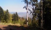

Guirbaden - Grendelbruch

tracegps
User

Length
26 km

Max alt
595 m

Uphill gradient
731 m

Km-Effort
35 km

Min alt
218 m

Downhill gradient
710 m
Boucle
No
Creation date :
2014-12-10 00:00:00.0
Updated on :
2014-12-10 00:00:00.0
2h30
Difficulty : Difficult

FREE GPS app for hiking
About
Trail Mountain bike of 26 km to be discovered at Grand Est, Bas-Rhin, Niederhaslach. This trail is proposed by tracegps.
Description
Une sortie sympa donnant sur divers points de vue. Il s'agit d'un circuit permettant de passer par le Château de Guirbaden et permettant de rejoindre le village de GRENDELBRUCH pour rejoindre à nouveau NIEDERHASALCH.
Positioning
Country:
France
Region :
Grand Est
Department/Province :
Bas-Rhin
Municipality :
Niederhaslach
Location:
Unknown
Start:(Dec)
Start:(UTM)
377902 ; 5377530 (32U) N.
Comments
Trails nearby
Cascade Soultzbach - Urmatt


Walking
Very difficult
(1)
Urmatt,
Grand Est,
Bas-Rhin,
France

14.9 km | 21 km-effort
4h 46min
Yes

Neufeld Boucle Elmersforst


Horseback riding
Difficult
(1)
Oberhaslach,
Grand Est,
Bas-Rhin,
France

31 km | 42 km-effort
5h 9min
Yes
Rando des Feuilles Mortes


Mountain bike
Medium
(2)
Oberhaslach,
Grand Est,
Bas-Rhin,
France

29 km | 41 km-effort
2h 0min
Yes
suuntoapp-HorsebackRiding-2024-04-28T06-24-49Z


Horseback riding
Difficult
Mollkirch,
Grand Est,
Bas-Rhin,
France

34 km | 48 km-effort
6h 20min
Yes

2024-02-07_22h30m09_B3


Walking
Medium
(1)
Still,
Grand Est,
Bas-Rhin,
France

16.8 km | 22 km-effort
4h 56min
Yes

Toutes fugues


Horseback riding
Easy
(1)
Niederhaslach,
Grand Est,
Bas-Rhin,
France

29 km | 39 km-effort
Unknown
Yes
2023-05-28 Picnic CVA Cabane des 5 routes


Horseback riding
Medium
Mollkirch,
Grand Est,
Bas-Rhin,
France

36 km | 51 km-effort
6h 39min
Yes
2022-07-10 Picnic CVA Umwurf depuis Oberhaslach


Horseback riding
Difficult
Still,
Grand Est,
Bas-Rhin,
France

28 km | 40 km-effort
5h 53min
Yes

2013-05-12 Picnic CVA Maennelstein


Equestrian
Medium
(1)
Rosheim,
Grand Est,
Bas-Rhin,
France

29 km | 41 km-effort
2h 33min
Yes


 SityTrail


