Trail Walking Lignereuil - Lignereuil Allée des tilleuls - Blavincourt - Denier - Photo

Lignereuil Allée des tilleuls - Blavincourt - Denier

 tracegps
tracegps

User

© OpenStreetMap contributors
Length
Length
11.2 km
Max alt
Max alt
154 m
Uphill gradient
Uphill gradient
111 m
Km-Effort
Km-Effort  
12.7 km
Min alt
Min alt
110 m
Downhill gradient
Downhill gradient
113 m
Boucle
Boucle
Yes
Creation date :
2014-12-10 00:00:00.0
Updated on :
2014-12-10 00:00:00.0

(0 Reviews)

Walking
Walking
2h00
Difficulty : Medium

Scan this QR Code to open this trail in the SityTrail application

FREE GPS app for hiking

Logo SityTrail SityTrail

IGN / Geographical institutes

Download SityTrail from the App Store Download SityTrail from Google Play

Logo SityTrail SityTrail World

The world is yours!

Download SityTrail from the App Store Download SityTrail from Google Play Download SityTrail on Huawei AppGallery

About

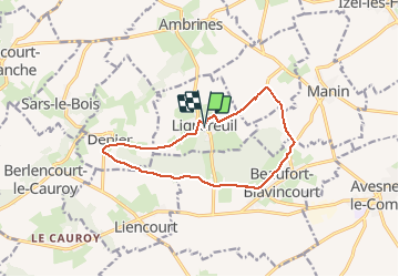
Trail Walking of 11.2 km to be discovered at Hauts-de-France, Pas-de-Calais, Lignereuil. This trail is proposed by tracegps.

Description

Randonnée du club Arras Inter Génération du 9 avril 2009. Très belle randonnée qui emprunte l'allée des tilleuls de Lignereuil à Gigenchy le Noble.

Elevation profile

Positioning

Country:
France
Region :
Hauts-de-France
Department/Province :
Pas-de-Calais
Municipality :
Lignereuil
Location:
Unknown
Start:(UTM)
462462 ; 5570975 (31U) N.

Trails nearby

Trail Mountain bike Avesnes-le-Comte - Les 6 châteaux - Avesnes le Comte - Photo
Mountain bike
tracegps

Mountain bike

Difficult
(1)
Avesnes-le-Comte, Hauts-de-France, Pas-de-Calais, France
44 km | 50 km-effort
2h 10min
Yes
Trail Walking Penin - Chemin des piedsentes  (Penin) - Photo
Walking
tracegps

Walking

Difficult
Penin, Hauts-de-France, Pas-de-Calais, France
14.5 km | 15.7 km-effort
3h 40min
Yes
Trail Walking Berlencourt-le-Cauroy - Le sentier du loup (Berlencourt-le-cauroy) - Photo
Walking
tracegps

Walking

Difficult
Berlencourt-le-Cauroy, Hauts-de-France, Pas-de-Calais, France
15.2 km | 17.3 km-effort
3h 45min
Yes
Trail Walking Lignereuil - LIGNEREUIL (62) - Par le bois du Fay - Photo
Walking
temmichel

Walking

Difficult
Lignereuil, Hauts-de-France, Pas-de-Calais, France
12.1 km | 13.5 km-effort
3h 4min
Yes
Trail Walking Avesnes-le-Comte - Avesnes le Comte, Noyelle-Vion, Manin, Beaufort-Blavincourt - Photo
Walking
tracegps

Walking

Medium
Avesnes-le-Comte, Hauts-de-France, Pas-de-Calais, France
10.8 km | 12.2 km-effort
2h 30min
Yes
Trail Walking Givenchy-le-Noble - Givenchy le Noble - Ambrines - Denier - Lignereuil - Photo
Walking
tracegps

Walking

Medium
Givenchy-le-Noble, Hauts-de-France, Pas-de-Calais, France
11 km | 12.5 km-effort
2h 0min
Yes
Trail Mountain bike Avesnes-le-Comte - Les six châteaux - Photo
Mountain bike
Gilbert62580

Mountain bike

Medium
Avesnes-le-Comte, Hauts-de-France, Pas-de-Calais, France
44 km | 50 km-effort
Unknown
Yes
Trail Walking Berlencourt-le-Cauroy - Berlencourt/Lucheux 23Kms Dén P 266m - Photo
Walking
alain62rando

Walking

Medium
Berlencourt-le-Cauroy, Hauts-de-France, Pas-de-Calais, France
23 km | 27 km-effort
5h 49min
No
Trail Walking Berlencourt-le-Cauroy - La Cauroy 11.3Kms Dén P 134m - Photo
Walking
alain62rando

Walking

Easy
Berlencourt-le-Cauroy, Hauts-de-France, Pas-de-Calais, France
11.5 km | 13.2 km-effort
2h 54min
Yes


Close
My subscriptions