![](/images/other/stat-length.png)
![Trail Mountain bike Pezou - Rando Pezou 2009 - Photo](https://media.geolcdn.com/t/1900/400/ext.pjpeg?maxdim=2&url=https%3A%2F%2Fstatic1.geolcdn.com%2Fsiteimages%2Fupload%2Ffiles%2F1524743154velo.jpg)
Rando Pezou 2009
tracegps
User
![Length](/images/other/stat-length.png)
Length
43 km
![Max alt](https://static1.geolcdn.com/siteimages/upload/files/1508320355ic_sort_altitude_max_24dp.png)
Max alt
151 m
![Uphill gradient](https://static1.geolcdn.com/siteimages/upload/files/1508320355ic_sort_den_pos_24dp.png)
Uphill gradient
583 m
![Km-Effort](/images/other/stat-length.png)
Km-Effort
50 km
![Min alt](https://static1.geolcdn.com/siteimages/upload/files/1508320355ic_sort_altitude_min_24dp.png)
Min alt
79 m
![Downhill gradient](https://static1.geolcdn.com/siteimages/upload/files/1508320355ic_sort_den_neg_24dp.png)
Downhill gradient
584 m
![Boucle](https://static1.geolcdn.com/siteimages/upload/files/16400158638029165_repeat_loop_refresh_sync_direction_icon.png)
Boucle
Yes
Creation date :
2014-12-10 00:00:00.0
Updated on :
2014-12-10 00:00:00.0
![Mountain bike](https://static1.geolcdn.com/sitytour/trail-icons/202.png)
2h45
Difficulty : Difficult
![Scan this QR Code to open this trail in the SityTrail application](https://capi.geolives.com/qq0zvz2zws4bq2lad0pu/sitytour/trails/103213/qr.png?size=200)
FREE GPS app for hiking
About
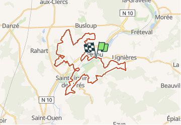
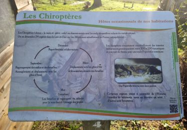
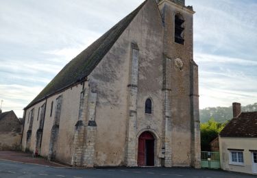
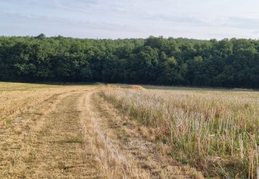
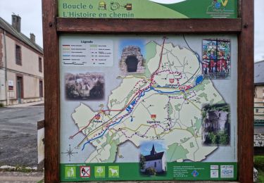
Trail Mountain bike of 43 km to be discovered at Centre-Loire Valley, Loir-et-Cher, Pezou. This trail is proposed by tracegps.
Description
Rando sur Pezou bien sympa, bonne montée par moment, de la route pour récupérer, du bois, pas trop de plaine et passage le long du Loir.
Positioning
Country:
France
Region :
Centre-Loire Valley
Department/Province :
Loir-et-Cher
Municipality :
Pezou
Location:
Unknown
Start:(Dec)
Start:(UTM)
361295 ; 5302740 (31T) N.
Comments
Trails nearby
![Trail Walking Fréteval - Fréteval - Champs Bois Grotte Étang - Photo](https://media.geolcdn.com/t/375/260/34045ca4-04f5-42e9-b8a9-99df3505cc2e.jpg&format=jpg&maxdim=2)
![Walking Walking](https://static1.geolcdn.com/sitytour/trail-icons/101.png)
Fréteval - Champs Bois Grotte Étang
Walking
Medium
Fréteval,
Centre-Loire Valley,
Loir-et-Cher,
France
![](/images/other/stat-length.png)
11 km | 12.4 km-effort
2h 49min
![](https://static1.geolcdn.com/siteimages/upload/files/16400158638029165_repeat_loop_refresh_sync_direction_icon.png)
Yes
![Trail Walking La Chapelle-Enchérie - La Chapelle-Enchérie - Bois de Bricsard - Photo](https://media.geolcdn.com/t/375/260/0862f641-e319-4701-963f-83d27a100897.jpg&format=jpg&maxdim=2)
![Walking Walking](https://static1.geolcdn.com/sitytour/trail-icons/101.png)
La Chapelle-Enchérie - Bois de Bricsard
Walking
Easy
La Chapelle-Enchérie,
Centre-Loire Valley,
Loir-et-Cher,
France
![](/images/other/stat-length.png)
9.1 km | 10.9 km-effort
2h 20min
![](https://static1.geolcdn.com/siteimages/upload/files/16400158638029165_repeat_loop_refresh_sync_direction_icon.png)
Yes
![Trail Walking Lisle - Lisle - Bord du Loir - Photo](https://media.geolcdn.com/t/375/260/4f9116bd-eecc-48ec-adb9-fd3c5cad4087.jpg&format=jpg&maxdim=2)
![Walking Walking](https://static1.geolcdn.com/sitytour/trail-icons/101.png)
Lisle - Bord du Loir
Walking
Easy
Lisle,
Centre-Loire Valley,
Loir-et-Cher,
France
![](/images/other/stat-length.png)
8.9 km | 9.5 km-effort
2h 9min
![](https://static1.geolcdn.com/siteimages/upload/files/16400158638029165_repeat_loop_refresh_sync_direction_icon.png)
Yes
![Trail Walking Saint-Firmin-des-Prés - Saint-Firmin-des-Prés - Photo](https://media.geolcdn.com/t/375/260/a5813cc0-d151-48d6-b693-f67e132742f6.jpg&format=jpg&maxdim=2)
![Walking Walking](https://static1.geolcdn.com/sitytour/trail-icons/101.png)
Saint-Firmin-des-Prés
Walking
Easy
Saint-Firmin-des-Prés,
Centre-Loire Valley,
Loir-et-Cher,
France
![](/images/other/stat-length.png)
8.9 km | 9.9 km-effort
1h 58min
![](https://static1.geolcdn.com/siteimages/upload/files/16400158638029165_repeat_loop_refresh_sync_direction_icon.png)
Yes
![Trail Walking Fréteval - Fréteval - Etang Champs Bois Donjon - Photo](https://media.geolcdn.com/t/375/260/dbe14c3b-b458-4462-84f4-1045ca1ab83b.jpg&format=jpg&maxdim=2)
![Walking Walking](https://static1.geolcdn.com/sitytour/trail-icons/101.png)
Fréteval - Etang Champs Bois Donjon
Walking
Medium
Fréteval,
Centre-Loire Valley,
Loir-et-Cher,
France
![](/images/other/stat-length.png)
10.8 km | 12.5 km-effort
2h 50min
![](https://static1.geolcdn.com/siteimages/upload/files/16400158638029165_repeat_loop_refresh_sync_direction_icon.png)
Yes
![Trail Walking Lisle - Lisle - Bois de l'Epau - Photo](https://media.geolcdn.com/t/375/260/f2ea5793-eafb-48f8-8f49-2ef6ceea9d28.jpg&format=jpg&maxdim=2)
![Walking Walking](https://static1.geolcdn.com/sitytour/trail-icons/101.png)
Lisle - Bois de l'Epau
Walking
Easy
Lisle,
Centre-Loire Valley,
Loir-et-Cher,
France
![](/images/other/stat-length.png)
8.9 km | 10.2 km-effort
2h 19min
![](https://static1.geolcdn.com/siteimages/upload/files/16400158638029165_repeat_loop_refresh_sync_direction_icon.png)
Yes
![Trail Walking Renay - Renay - Champs Bois Chapelle Eglise - Photo](https://media.geolcdn.com/t/375/260/ddc8d202-9993-403c-b2f2-d3983276bdc7.jpg&format=jpg&maxdim=2)
![Walking Walking](https://static1.geolcdn.com/sitytour/trail-icons/101.png)
Renay - Champs Bois Chapelle Eglise
Walking
Medium
Renay,
Centre-Loire Valley,
Loir-et-Cher,
France
![](/images/other/stat-length.png)
13.8 km | 15.8 km-effort
3h 35min
![](https://static1.geolcdn.com/siteimages/upload/files/16400158638029165_repeat_loop_refresh_sync_direction_icon.png)
Yes
![Trail Walking Fréteval - Fréteval - L'histoire en chemin - Photo](https://media.geolcdn.com/t/375/260/dd7bbd73-a31b-4596-b9ef-a372bb9665f7.jpg&format=jpg&maxdim=2)
![Walking Walking](https://static1.geolcdn.com/sitytour/trail-icons/101.png)
Fréteval - L'histoire en chemin
Walking
Easy
Fréteval,
Centre-Loire Valley,
Loir-et-Cher,
France
![](/images/other/stat-length.png)
19.7 km | 22 km-effort
6h 25min
![](https://static1.geolcdn.com/siteimages/upload/files/16400158638029165_repeat_loop_refresh_sync_direction_icon.png)
Yes
![Trail Cycle Fréteval - Circuit des 2 coteaux - Fréteval - Photo](https://media.geolcdn.com/t/375/260/ext.jpg?maxdim=2&url=https%3A%2F%2Fservices.sitytrail.com%2FGeolivesWS%2FDownloadMedia.ashx%3FTrailID%3D112184%26Media%3D10045_6.jpg)
![Cycle Cycle](https://static1.geolcdn.com/sitytour/trail-icons/200.png)
Circuit des 2 coteaux - Fréteval
Cycle
Difficult
Fréteval,
Centre-Loire Valley,
Loir-et-Cher,
France
![](/images/other/stat-length.png)
48 km | 54 km-effort
3h 0min
![](https://static1.geolcdn.com/siteimages/upload/files/16400158638029165_repeat_loop_refresh_sync_direction_icon.png)
Yes