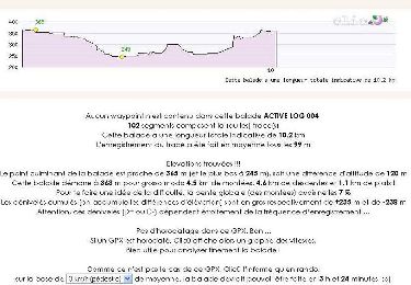
![](/images/other/stat-length.png)
![Trail Walking Latrape - De Latrape au Cap del Bose - Photo](https://media.geolcdn.com/t/1900/400/ext.pjpeg?maxdim=2&url=https%3A%2F%2Fservices.sitytrail.com%2FGeolivesWS%2FDownloadMedia.ashx%3FTrailID%3D103180%26Media%3D5007_1.jpg)
De Latrape au Cap del Bose
tracegps
User
![Length](/images/other/stat-length.png)
Length
6.4 km
![Max alt](https://static1.geolcdn.com/siteimages/upload/files/1508320355ic_sort_altitude_max_24dp.png)
Max alt
368 m
![Uphill gradient](https://static1.geolcdn.com/siteimages/upload/files/1508320355ic_sort_den_pos_24dp.png)
Uphill gradient
123 m
![Km-Effort](/images/other/stat-length.png)
Km-Effort
8.1 km
![Min alt](https://static1.geolcdn.com/siteimages/upload/files/1508320355ic_sort_altitude_min_24dp.png)
Min alt
257 m
![Downhill gradient](https://static1.geolcdn.com/siteimages/upload/files/1508320355ic_sort_den_neg_24dp.png)
Downhill gradient
123 m
![Boucle](https://static1.geolcdn.com/siteimages/upload/files/16400158638029165_repeat_loop_refresh_sync_direction_icon.png)
Boucle
Yes
Creation date :
2014-12-10 00:00:00.0
Updated on :
2014-12-10 00:00:00.0
![Walking](https://static1.geolcdn.com/sitytour/trail-icons/101.png)
2h45
Difficulty : Medium
![Scan this QR Code to open this trail in the SityTrail application](https://capi.geolives.com/qq0zvz2zws4bq2lad0pu/sitytour/trails/103180/qr.png?size=200)
FREE GPS app for hiking
About
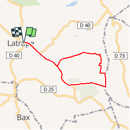
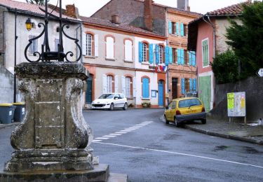
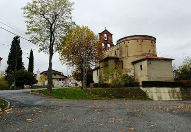
Trail Walking of 6.4 km to be discovered at Occitania, Haute-Garonne, Latrape. This trail is proposed by tracegps.
Description
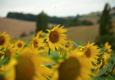
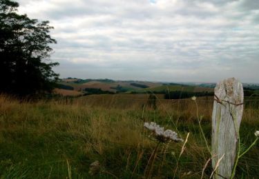
Balades en Volvestre sur les chemins de Latrape. Promenade autour du village, sur les coteaux et terreforts combinant un magnifique panorama sur la chaîne des Pyrénées. Bocage riche en faune et flore le long du ruisseau, du Camedon, de l'Aunat et le pont de Brucelle.
Positioning
Country:
France
Region :
Occitania
Department/Province :
Haute-Garonne
Municipality :
Latrape
Location:
Unknown
Start:(Dec)
Start:(UTM)
361027 ; 4789429 (31T) N.
Comments
Trails nearby
![Trail Walking Latrape - Latrape - Photo](https://media.geolcdn.com/t/375/260/ext.jpg?maxdim=2&url=https%3A%2F%2Fservices.sitytrail.com%2FGeolivesWS%2FDownloadMedia.ashx%3FTrailID%3D695682%26Media%3Df4e58813-a7a8-42ca-87be-2c32be993f8b.JPG)
![Walking Walking](https://static1.geolcdn.com/sitytour/trail-icons/101.png)
![Trail Equestrian Lézat-sur-Lèze - Lézat sur Lèze - Saint Ybard - Photo](https://media.geolcdn.com/t/375/260/ext.jpg?maxdim=2&url=https%3A%2F%2Fservices.sitytrail.com%2FGeolivesWS%2FDownloadMedia.ashx%3FTrailID%3D108223%26Media%3D861_1.jpg)
![Equestrian Equestrian](https://static1.geolcdn.com/sitytour/trail-icons/300.png)
Lézat sur Lèze - Saint Ybard
Equestrian
Medium
Lézat-sur-Lèze,
Occitania,
Ariège,
France
![](/images/other/stat-length.png)
9.1 km | 11.9 km-effort
1h 0min
![](https://static1.geolcdn.com/siteimages/upload/files/16400158638029165_repeat_loop_refresh_sync_direction_icon.png)
No
![Trail Walking Latrape - Boucle de Latrape - Photo](https://media.geolcdn.com/t/375/260/ext.jpg?maxdim=2&url=https%3A%2F%2Fservices.sitytrail.com%2FGeolivesWS%2FDownloadMedia.ashx%3FTrailID%3D107673%26Media%3D12678_2.jpg)
![Walking Walking](https://static1.geolcdn.com/sitytour/trail-icons/101.png)
Boucle de Latrape
Walking
Medium
Latrape,
Occitania,
Haute-Garonne,
France
![](/images/other/stat-length.png)
10.2 km | 12.8 km-effort
3h 0min
![](https://static1.geolcdn.com/siteimages/upload/files/16400158638029165_repeat_loop_refresh_sync_direction_icon.png)
Yes
![Trail Walking Latrape - Grand tour de Latrape - Photo](https://media.geolcdn.com/t/375/260/ext.jpg?maxdim=2&url=https%3A%2F%2Fservices.sitytrail.com%2FGeolivesWS%2FDownloadMedia.ashx%3FTrailID%3D103181%26Media%3D5008_1.jpg)
![Walking Walking](https://static1.geolcdn.com/sitytour/trail-icons/101.png)
Grand tour de Latrape
Walking
Medium
Latrape,
Occitania,
Haute-Garonne,
France
![](/images/other/stat-length.png)
9.2 km | 11.5 km-effort
3h 0min
![](https://static1.geolcdn.com/siteimages/upload/files/16400158638029165_repeat_loop_refresh_sync_direction_icon.png)
Yes
![Trail Walking Latrape - De Latrape à l'Aunat - Photo](https://media.geolcdn.com/t/375/260/ext.jpg?maxdim=2&url=https%3A%2F%2Fservices.sitytrail.com%2FGeolivesWS%2FDownloadMedia.ashx%3FTrailID%3D103179%26Media%3D5006_1.jpg)
![Walking Walking](https://static1.geolcdn.com/sitytour/trail-icons/101.png)
De Latrape à l'Aunat
Walking
Medium
Latrape,
Occitania,
Haute-Garonne,
France
![](/images/other/stat-length.png)
7.2 km | 9.4 km-effort
2h 0min
![](https://static1.geolcdn.com/siteimages/upload/files/16400158638029165_repeat_loop_refresh_sync_direction_icon.png)
Yes
![Trail Walking Latrape - De Latrape au château de Mailholas - Photo](https://media.geolcdn.com/t/375/260/ext.jpg?maxdim=2&url=https%3A%2F%2Fservices.sitytrail.com%2FGeolivesWS%2FDownloadMedia.ashx%3FTrailID%3D103178%26Media%3D5005_1.jpg)
![Walking Walking](https://static1.geolcdn.com/sitytour/trail-icons/101.png)
De Latrape au château de Mailholas
Walking
Medium
Latrape,
Occitania,
Haute-Garonne,
France
![](/images/other/stat-length.png)
8.7 km | 11.4 km-effort
2h 30min
![](https://static1.geolcdn.com/siteimages/upload/files/16400158638029165_repeat_loop_refresh_sync_direction_icon.png)
Yes
![Trail Walking Latrape - De Latrape à Règue Longue - Photo](https://media.geolcdn.com/t/375/260/ext.jpg?maxdim=2&url=https%3A%2F%2Fservices.sitytrail.com%2FGeolivesWS%2FDownloadMedia.ashx%3FTrailID%3D103136%26Media%3D4923_1.jpg)
![Walking Walking](https://static1.geolcdn.com/sitytour/trail-icons/101.png)
De Latrape à Règue Longue
Walking
Easy
Latrape,
Occitania,
Haute-Garonne,
France
![](/images/other/stat-length.png)
7.3 km | 9.9 km-effort
1h 30min
![](https://static1.geolcdn.com/siteimages/upload/files/16400158638029165_repeat_loop_refresh_sync_direction_icon.png)
Yes
![Trail Walking Lézat-sur-Lèze - Lézat sans boue fait 2022 - Photo](https://media.geolcdn.com/t/375/260/ext.jpg?maxdim=2&url=https%3A%2F%2Fstatic1.geolcdn.com%2Fsiteimages%2Fupload%2Ffiles%2F1553511878bg_sport_marche.png)
![Walking Walking](https://static1.geolcdn.com/sitytour/trail-icons/101.png)
Lézat sans boue fait 2022
Walking
Medium
Lézat-sur-Lèze,
Occitania,
Ariège,
France
![](/images/other/stat-length.png)
10.7 km | 13.7 km-effort
2h 28min
![](https://static1.geolcdn.com/siteimages/upload/files/16400158638029165_repeat_loop_refresh_sync_direction_icon.png)
Yes
![Trail On foot Rieux-Volvestre - De la Cathédrale au chemin de la Coque et du Vila - Photo](https://media.geolcdn.com/t/375/260/ext.jpg?maxdim=2&url=https%3A%2F%2Fstatic1.geolcdn.com%2Fsiteimages%2Fupload%2Ffiles%2F1545311037marcheuse_200dpi.jpg)
![On foot On foot](https://static1.geolcdn.com/sitytour/trail-icons/100.png)
De la Cathédrale au chemin de la Coque et du Vila
On foot
Easy
Rieux-Volvestre,
Occitania,
Haute-Garonne,
France
![](/images/other/stat-length.png)
3.9 km | 5.4 km-effort
1h 13min
![](https://static1.geolcdn.com/siteimages/upload/files/16400158638029165_repeat_loop_refresh_sync_direction_icon.png)
No