![](/images/other/stat-length.png)
![Trail Walking Lardy - Autour de Lardy - Photo](https://media.geolcdn.com/t/1900/400/ext.pjpeg?maxdim=2&url=https%3A%2F%2Fservices.sitytrail.com%2FGeolivesWS%2FDownloadMedia.ashx%3FTrailID%3D103176%26Media%3D5001_2.jpg)
Autour de Lardy
tracegps
User
![Length](/images/other/stat-length.png)
Length
14.1 km
![Max alt](https://static1.geolcdn.com/siteimages/upload/files/1508320355ic_sort_altitude_max_24dp.png)
Max alt
162 m
![Uphill gradient](https://static1.geolcdn.com/siteimages/upload/files/1508320355ic_sort_den_pos_24dp.png)
Uphill gradient
239 m
![Km-Effort](/images/other/stat-length.png)
Km-Effort
17.3 km
![Min alt](https://static1.geolcdn.com/siteimages/upload/files/1508320355ic_sort_altitude_min_24dp.png)
Min alt
58 m
![Downhill gradient](https://static1.geolcdn.com/siteimages/upload/files/1508320355ic_sort_den_neg_24dp.png)
Downhill gradient
241 m
![Boucle](https://static1.geolcdn.com/siteimages/upload/files/16400158638029165_repeat_loop_refresh_sync_direction_icon.png)
Boucle
Yes
Creation date :
2014-12-10 00:00:00.0
Updated on :
2014-12-10 00:00:00.0
![Walking](https://static1.geolcdn.com/sitytour/trail-icons/101.png)
4h00
Difficulty : Medium
![Scan this QR Code to open this trail in the SityTrail application](https://capi.geolives.com/qq0zvz2zws4bq2lad0pu/sitytour/trails/103176/qr.png?size=200)
FREE GPS app for hiking
About
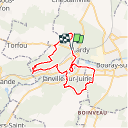
Trail Walking of 14.1 km to be discovered at Ile-de-France, Essonne, Lardy. This trail is proposed by tracegps.
Description
Autour de Lardy Randonnée de 14 km sur chaque coteau de la vallée, traversant des bois, la ville château et parc. D’autres informations et photos sont disponibles ICI
Positioning
Country:
France
Region :
Ile-de-France
Department/Province :
Essonne
Municipality :
Lardy
Location:
Unknown
Start:(Dec)
Start:(UTM)
445762 ; 5375232 (31U) N.
Comments
Trails nearby
![Trail Walking Lardy - Lardy - Chamarande -F - Photo](https://media.geolcdn.com/t/375/260/ext.jpg?maxdim=2&url=https%3A%2F%2Fservices.sitytrail.com%2FGeolivesWS%2FDownloadMedia.ashx%3FTrailID%3D274259%26Media%3Dfix__20140504142726.jpg)
![Walking Walking](https://static1.geolcdn.com/sitytour/trail-icons/101.png)
Lardy - Chamarande -F
Walking
Medium
(2)
Lardy,
Ile-de-France,
Essonne,
France
![](/images/other/stat-length.png)
18.3 km | 22 km-effort
4h 44min
![](https://static1.geolcdn.com/siteimages/upload/files/16400158638029165_repeat_loop_refresh_sync_direction_icon.png)
Yes
![Trail Walking Marolles-en-Hurepoix - Marolles Lardy Bouray St Vrain - Photo](https://media.geolcdn.com/t/375/260/33c381bd-a07a-4eb0-86bc-485e818428bf.jpg&format=jpg&maxdim=2)
![Walking Walking](https://static1.geolcdn.com/sitytour/trail-icons/101.png)
Marolles Lardy Bouray St Vrain
Walking
Medium
(1)
Marolles-en-Hurepoix,
Ile-de-France,
Essonne,
France
![](/images/other/stat-length.png)
19.3 km | 23 km-effort
5h 10min
![](https://static1.geolcdn.com/siteimages/upload/files/16400158638029165_repeat_loop_refresh_sync_direction_icon.png)
Yes
![Trail Walking Lardy - Autour de Lardy par la Pierre levée de Janville sur Juine - Photo](https://media.geolcdn.com/t/375/260/ext.jpg?maxdim=2&url=https%3A%2F%2Fservices.sitytrail.com%2FGeolivesWS%2FDownloadMedia.ashx%3FTrailID%3D110136%26Media%3D5334_1.jpg)
![Walking Walking](https://static1.geolcdn.com/sitytour/trail-icons/101.png)
Autour de Lardy par la Pierre levée de Janville sur Juine
Walking
Difficult
(1)
Lardy,
Ile-de-France,
Essonne,
France
![](/images/other/stat-length.png)
24 km | 29 km-effort
4h 49min
![](https://static1.geolcdn.com/siteimages/upload/files/16400158638029165_repeat_loop_refresh_sync_direction_icon.png)
Yes
![Trail Mountain bike Lardy - Autour de Lardy en VTT - Photo](https://media.geolcdn.com/t/375/260/ext.jpg?maxdim=2&url=https%3A%2F%2Fservices.sitytrail.com%2FGeolivesWS%2FDownloadMedia.ashx%3FTrailID%3D104079%26Media%3D7075_1.jpg)
![Mountain bike Mountain bike](https://static1.geolcdn.com/sitytour/trail-icons/202.png)
Autour de Lardy en VTT
Mountain bike
Medium
(1)
Lardy,
Ile-de-France,
Essonne,
France
![](/images/other/stat-length.png)
31 km | 38 km-effort
2h 4min
![](https://static1.geolcdn.com/siteimages/upload/files/16400158638029165_repeat_loop_refresh_sync_direction_icon.png)
Yes
![Trail Walking Chamarande - bois de belvedere au depart de chamarande - Photo](https://media.geolcdn.com/t/375/260/ext.jpg?maxdim=2&url=https%3A%2F%2Fstatic1.geolcdn.com%2Fsiteimages%2Fupload%2Ffiles%2F1553511878bg_sport_marche.png)
![Walking Walking](https://static1.geolcdn.com/sitytour/trail-icons/101.png)
bois de belvedere au depart de chamarande
Walking
Difficult
(1)
Chamarande,
Ile-de-France,
Essonne,
France
![](/images/other/stat-length.png)
12.6 km | 17.2 km-effort
3h 54min
![](https://static1.geolcdn.com/siteimages/upload/files/16400158638029165_repeat_loop_refresh_sync_direction_icon.png)
Yes
![Trail On foot Lardy - Boucle Lardy par Pascale - Photo](https://media.geolcdn.com/t/375/260/fcd0ce26-70c7-4c63-8ed6-22b96bedd69d.jpg&format=jpg&maxdim=2)
![On foot On foot](https://static1.geolcdn.com/sitytour/trail-icons/100.png)
Boucle Lardy par Pascale
On foot
Easy
Lardy,
Ile-de-France,
Essonne,
France
![](/images/other/stat-length.png)
20 km | 25 km-effort
5h 36min
![](https://static1.geolcdn.com/siteimages/upload/files/16400158638029165_repeat_loop_refresh_sync_direction_icon.png)
Yes
![Trail On foot Auvers-Saint-Georges - Au grès de la Juine - Photo](https://media.geolcdn.com/t/375/260/72c017b2-4cbc-4eae-9d9f-90478ed2d91b.jpeg&format=jpg&maxdim=2)
![On foot On foot](https://static1.geolcdn.com/sitytour/trail-icons/100.png)
Au grès de la Juine
On foot
Medium
Auvers-Saint-Georges,
Ile-de-France,
Essonne,
France
![](/images/other/stat-length.png)
22 km | 27 km-effort
6h 10min
![](https://static1.geolcdn.com/siteimages/upload/files/16400158638029165_repeat_loop_refresh_sync_direction_icon.png)
No
![Trail On foot Saint-Yon - Sur les traces de la Renarde - Photo](https://media.geolcdn.com/t/375/260/422df56a-01d7-491a-a40b-c7b9da63fbd0.jpeg&format=jpg&maxdim=2)
![On foot On foot](https://static1.geolcdn.com/sitytour/trail-icons/100.png)
Sur les traces de la Renarde
On foot
Very difficult
Saint-Yon,
Ile-de-France,
Essonne,
France
![](/images/other/stat-length.png)
38 km | 44 km-effort
10h 4min
![](https://static1.geolcdn.com/siteimages/upload/files/16400158638029165_repeat_loop_refresh_sync_direction_icon.png)
No
![Trail Walking Bouray-sur-Juine - Boucle autour de Bouray/ Juine et Chamarande - Photo](https://media.geolcdn.com/t/375/260/8a690f2b-8cc2-47e4-bc80-9363263d7ddd.jpg&format=jpg&maxdim=2)
![Walking Walking](https://static1.geolcdn.com/sitytour/trail-icons/101.png)
Boucle autour de Bouray/ Juine et Chamarande
Walking
Medium
Bouray-sur-Juine,
Ile-de-France,
Essonne,
France
![](/images/other/stat-length.png)
24 km | 29 km-effort
5h 18min
![](https://static1.geolcdn.com/siteimages/upload/files/16400158638029165_repeat_loop_refresh_sync_direction_icon.png)
Yes