Trail Walking Brunehaut - Menhir Pierre Brunehaut - Photo

Menhir Pierre Brunehaut

 tracegps
tracegps

User

© OpenStreetMap contributors
Length
Length
9.6 km
Max alt
Max alt
35 m
Uphill gradient
Uphill gradient
49 m
Km-Effort
Km-Effort  
10.3 km
Min alt
Min alt
15 m
Downhill gradient
Downhill gradient
48 m
Boucle
Boucle
No
Creation date :
2014-12-10 00:00:00.0
Updated on :
2014-12-10 00:00:00.0

(1 Reviews)

Walking
Walking
2h00
Difficulty : Difficult

Scan this QR Code to open this trail in the SityTrail application

FREE GPS app for hiking

Logo SityTrail SityTrail

IGN / Geographical institutes

Download SityTrail from the App Store Download SityTrail from Google Play

Logo SityTrail SityTrail World

The world is yours!

Download SityTrail from the App Store Download SityTrail from Google Play Download SityTrail on Huawei AppGallery

About

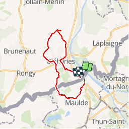
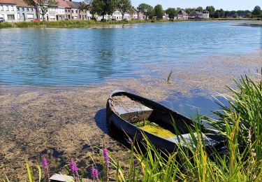
Trail Walking of 9.6 km to be discovered at Wallonia, Hainaut, Brunehaut. This trail is proposed by tracegps.

Description

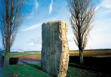
Mehnir de -2500 av JC. Départ de Maulde France et arrivée au parking de la place de Maulde. La pierre Brunehaut est le mégalithique le plus imposant de Belgique .

Elevation profile

Photos

Points of interest

Point of interest Brunehaut - 010 - Photo
tracegps
BRUNEHAUT 
Point of interest Maulde - Bloq - Photo
tracegps
MAULDE 
Point of interest Brunehaut - N 3 - Photo
tracegps
BRUNEHAUT 
Point of interest Brunehaut - N 4 - Photo
tracegps
BRUNEHAUT 
Point of interest Brunehaut - N 5 - Photo
tracegps
BRUNEHAUT 

Positioning

Country:
Belgium
Region :
Wallonia
Department/Province :
Hainaut
Municipality :
Brunehaut
Location:
Bléharies
Start:(UTM)
530417 ; 5594951 (31U) N.

Comments

Please log in to post a review or rate the element


Trails nearby

Trail Walking Antoing - grand large- penonnes lez antoing - Photo
Walking
papiou

Walking

Easy
(3)
Antoing, Wallonia, Hainaut, Belgium
9.9 km | 10.7 km-effort
2h 12min
Yes
Trail Walking Brunehaut - Circuit de la coupure de Bléharies   - Photo
Walking
GUIDE+

Walking

Easy
Brunehaut, Wallonia, Hainaut, Belgium
3.7 km | 4 km-effort
54min
Yes
Trail Walking Antoing - Balade au coeur de Péronnes - Photo
Walking
GUIDE+

Walking

Easy
(1)
Antoing, Wallonia, Hainaut, Belgium
4.5 km | 4.9 km-effort
1h 6min
Yes
Trail Equestrian Brunehaut - Loop of Brunehaut - Photo
Equestrian
GUIDE+

Equestrian

Very easy
Brunehaut, Wallonia, Hainaut, Belgium
13.2 km | 14.1 km-effort
Unknown
Yes
Trail On foot Brunehaut - A tour of the plant and tree nurseries at Lesdain - Photo
On foot
GUIDE+

On foot

Easy
(1)
Brunehaut, Wallonia, Hainaut, Belgium
6.2 km | 6.6 km-effort
1h 29min
Yes
Trail On foot Brunehaut - Bléharies severed meander bird watching walking tour - 3,5km - Photo
On foot
GUIDE+

On foot

Easy
Brunehaut, Wallonia, Hainaut, Belgium
3.7 km | 3.9 km-effort
53min
Yes
Trail Walking Mortagne-du-Nord - Mortagne-du-Nord 18,6 km - Photo
Walking
GUIDE
rvapeldo

Walking

Mortagne-du-Nord, Hauts-de-France, Nord, France
18.6 km | 20 km-effort
4h 20min
Yes
Trail Walking Brunehaut - RB - H - 15 Lesdain - Photo
Walking
GUIDE
romanceline

Walking

Very easy
Brunehaut, Wallonia, Hainaut, Belgium
17.7 km | 18.9 km-effort
3h 55min
Yes
Trail Walking Brunehaut - Hollain 16,2 km - Photo
Walking
GUIDE
rvapeldo

Walking

Medium
Brunehaut, Wallonia, Hainaut, Belgium
16.3 km | 17.4 km-effort
4h 35min
Yes


Close
My subscriptions