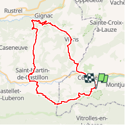
![](/images/other/stat-length.png)
![Trail Mountain bike Céreste - De Céreste à Saint Martin de Castillon - Photo](https://media.geolcdn.com/t/1900/400/ext.pjpeg?maxdim=2&url=https%3A%2F%2Fservices.sitytrail.com%2FGeolivesWS%2FDownloadMedia.ashx%3FTrailID%3D103102%26Media%3D4830_1.jpg)
De Céreste à Saint Martin de Castillon
tracegps
User
![Length](/images/other/stat-length.png)
![Max alt](https://static1.geolcdn.com/siteimages/upload/files/1508320355ic_sort_altitude_max_24dp.png)
![Uphill gradient](https://static1.geolcdn.com/siteimages/upload/files/1508320355ic_sort_den_pos_24dp.png)
![Km-Effort](/images/other/stat-length.png)
![Min alt](https://static1.geolcdn.com/siteimages/upload/files/1508320355ic_sort_altitude_min_24dp.png)
![Downhill gradient](https://static1.geolcdn.com/siteimages/upload/files/1508320355ic_sort_den_neg_24dp.png)
![Boucle](https://static1.geolcdn.com/siteimages/upload/files/16400158638029165_repeat_loop_refresh_sync_direction_icon.png)
![Mountain bike](https://static1.geolcdn.com/sitytour/trail-icons/202.png)
4h00
Difficulty : Difficult
![Scan this QR Code to open this trail in the SityTrail application](https://capi.geolives.com/qq0zvz2zws4bq2lad0pu/sitytour/trails/103102/qr.png?size=200)
FREE GPS app for hiking
About
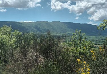
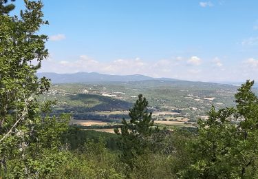
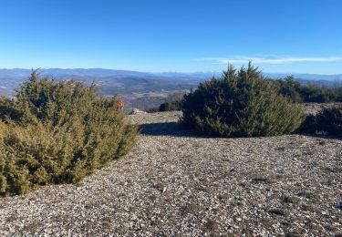
Trail Mountain bike of 37 km to be discovered at Provence-Alpes-Côte d'Azur, Alpes-de-Haute-Provence, Céreste. This trail is proposed by tracegps.
Description
La ferme équestre La Florentine offre la possibilité de découvrir le Luberon à cheval dans un cadre d'une beauté rare. Cette beauté est celle d'une nature préservée, celle qui caractérise le nord du Luberon. Le gîte d'étape, le studio duplex et les 3 chambres d'hôte sont aussi prévus pour des séjours de détente. De Céreste à Saint Martin de Castillon A cheval, ce circuit se fait en 2 jours avec une nuit au Colorado Provençal (Bivouac ou nuit au Gite de Rustrel). Deux petites journées qui permettent de visiter les ocres à pied.
Positioning
Comments
Trails nearby
![Trail Walking Céreste - CERESTE .PRIEURÉ DE CARLUC N - Photo](https://media.geolcdn.com/t/375/260/831b0a2c-7338-4c58-839a-49cbe3dc2550.jpg&format=jpg&maxdim=2)
![Walking Walking](https://static1.geolcdn.com/sitytour/trail-icons/101.png)
Walking
![](/images/other/stat-length.png)
![](https://static1.geolcdn.com/siteimages/upload/files/16400158638029165_repeat_loop_refresh_sync_direction_icon.png)
![Trail Walking Reillanne - reillane. carluc - Photo](https://media.geolcdn.com/t/375/260/a5a55962-1bef-44bc-99af-6edbc297f6a6.jpg&format=jpg&maxdim=2)
![Walking Walking](https://static1.geolcdn.com/sitytour/trail-icons/101.png)
Walking
![](/images/other/stat-length.png)
![](https://static1.geolcdn.com/siteimages/upload/files/16400158638029165_repeat_loop_refresh_sync_direction_icon.png)
![Trail Walking La Bastide-des-Jourdans - Les Collets du Luberon Est - Photo](https://media.geolcdn.com/t/375/260/ext.jpg?maxdim=2&url=https%3A%2F%2Fstatic1.geolcdn.com%2Fsiteimages%2Fupload%2Ffiles%2F1553511878bg_sport_marche.png)
![Walking Walking](https://static1.geolcdn.com/sitytour/trail-icons/101.png)
Walking
![](/images/other/stat-length.png)
![](https://static1.geolcdn.com/siteimages/upload/files/16400158638029165_repeat_loop_refresh_sync_direction_icon.png)
![Trail Walking Reillanne - 2024-03-01 Tour de Reillanne - Photo](https://media.geolcdn.com/t/375/260/71fa3e0d-dd40-4573-92ce-a7ebbe393b9d.jpg&format=jpg&maxdim=2)
![Walking Walking](https://static1.geolcdn.com/sitytour/trail-icons/101.png)
Walking
![](/images/other/stat-length.png)
![](https://static1.geolcdn.com/siteimages/upload/files/16400158638029165_repeat_loop_refresh_sync_direction_icon.png)
![Trail Walking Céreste - Colline de la Gardette-Céreste-08-05-23 - Photo](https://media.geolcdn.com/t/375/260/a8b4d2c3-aa6a-406b-8845-5eda9206752a.jpg&format=jpg&maxdim=2)
![Walking Walking](https://static1.geolcdn.com/sitytour/trail-icons/101.png)
Walking
![](/images/other/stat-length.png)
![](https://static1.geolcdn.com/siteimages/upload/files/16400158638029165_repeat_loop_refresh_sync_direction_icon.png)
![Trail Walking Céreste - Cereste - Photo](https://media.geolcdn.com/t/375/260/207a6c62-29ec-454a-a989-b91a6e9da588.jpg&format=jpg&maxdim=2)
![Walking Walking](https://static1.geolcdn.com/sitytour/trail-icons/101.png)
Walking
![](/images/other/stat-length.png)
![](https://static1.geolcdn.com/siteimages/upload/files/16400158638029165_repeat_loop_refresh_sync_direction_icon.png)
![Trail Walking Vitrolles-en-Luberon - Mascas Mourre negre - Photo](https://media.geolcdn.com/t/375/260/ec51df23-2df3-41b4-a86b-282bb2a3d7ef.jpg&format=jpg&maxdim=2)
![Walking Walking](https://static1.geolcdn.com/sitytour/trail-icons/101.png)
Walking
![](/images/other/stat-length.png)
![](https://static1.geolcdn.com/siteimages/upload/files/16400158638029165_repeat_loop_refresh_sync_direction_icon.png)
![Trail Walking Vitrolles-en-Luberon - vitrolles en Lubéron. aire des mascas - Photo](https://media.geolcdn.com/t/375/260/0ccb0f0d-bff8-46ee-add9-4b453c363566.jpg&format=jpg&maxdim=2)
![Walking Walking](https://static1.geolcdn.com/sitytour/trail-icons/101.png)
Walking
![](/images/other/stat-length.png)
![](https://static1.geolcdn.com/siteimages/upload/files/16400158638029165_repeat_loop_refresh_sync_direction_icon.png)
![Trail Walking Céreste - Col des Mascas 84 - Photo](https://media.geolcdn.com/t/375/260/5f8a8e95-e4b9-4f51-b3ee-2dd34976b29d.jpg&format=jpg&maxdim=2)
![Walking Walking](https://static1.geolcdn.com/sitytour/trail-icons/101.png)
Walking
![](/images/other/stat-length.png)
![](https://static1.geolcdn.com/siteimages/upload/files/16400158638029165_repeat_loop_refresh_sync_direction_icon.png)