![](/images/other/stat-length.png)
![Trail Walking Lagos - Lagos - Circuit des pins Laricio - Photo](https://media.geolcdn.com/t/1900/400/ext.pjpeg?maxdim=2&url=https%3A%2F%2Fservices.sitytrail.com%2FGeolivesWS%2FDownloadMedia.ashx%3FTrailID%3D103068%26Media%3D4737_2.jpg)
Lagos - Circuit des pins Laricio
tracegps
User
![Length](/images/other/stat-length.png)
![Max alt](https://static1.geolcdn.com/siteimages/upload/files/1508320355ic_sort_altitude_max_24dp.png)
![Uphill gradient](https://static1.geolcdn.com/siteimages/upload/files/1508320355ic_sort_den_pos_24dp.png)
![Km-Effort](/images/other/stat-length.png)
![Min alt](https://static1.geolcdn.com/siteimages/upload/files/1508320355ic_sort_altitude_min_24dp.png)
![Downhill gradient](https://static1.geolcdn.com/siteimages/upload/files/1508320355ic_sort_den_neg_24dp.png)
![Boucle](https://static1.geolcdn.com/siteimages/upload/files/16400158638029165_repeat_loop_refresh_sync_direction_icon.png)
![Walking](https://static1.geolcdn.com/sitytour/trail-icons/101.png)
2h00
Difficulty : Easy
![Scan this QR Code to open this trail in the SityTrail application](https://capi.geolives.com/qq0zvz2zws4bq2lad0pu/sitytour/trails/103068/qr.png?size=200)
FREE GPS app for hiking
About
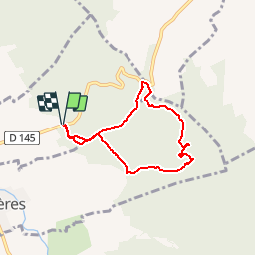
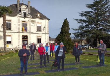
Trail Walking of 6.3 km to be discovered at New Aquitaine, Pyrénées-Atlantiques, Lagos. This trail is proposed by tracegps.
Description
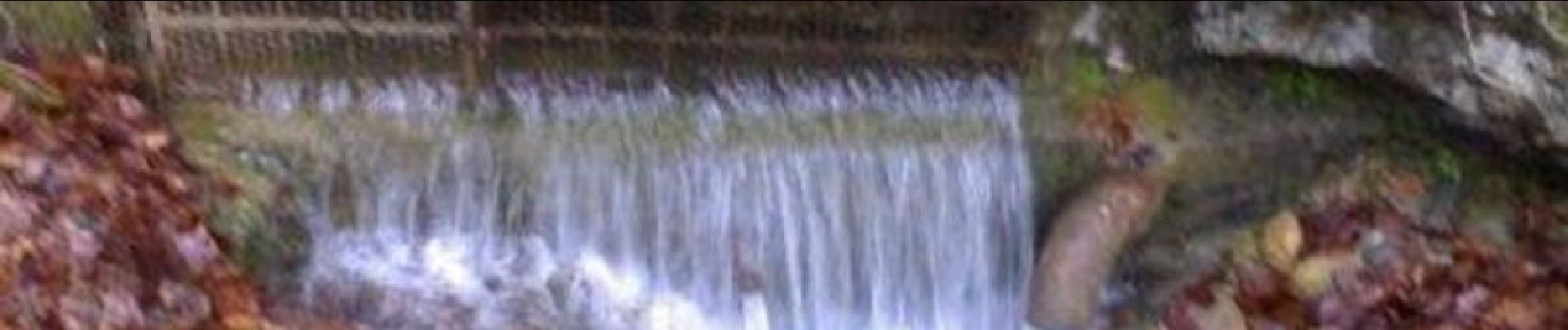
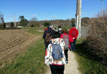
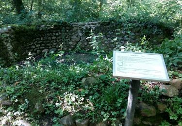
Petite balade dans le bois de chênes et de hêtres clairsemés, où on été plantés, en 1952, des pins Laricio, des pins à l'Encens et des Douglas verts. Au mois d'avril on pourra admirer de nombreuses Asphodèles, des Ancolies en fleurs et des pieds de myrtilles. A l'est de la boucle, il ne faut pas rater la source de la Moule. Puis, on longe un ruisseau dans un charmant vallon tapissé de sables provenant d'anciens rivages des mers de l'ère secondaire.
Positioning
Comments
Trails nearby
![Trail Walking Espoey - Mairie à Mairie1 - Photo](https://media.geolcdn.com/t/375/260/ext.jpg?maxdim=2&url=https%3A%2F%2Fstatic1.geolcdn.com%2Fsiteimages%2Fupload%2Ffiles%2F1553511878bg_sport_marche.png)
![Walking Walking](https://static1.geolcdn.com/sitytour/trail-icons/101.png)
Walking
![](/images/other/stat-length.png)
![](https://static1.geolcdn.com/siteimages/upload/files/16400158638029165_repeat_loop_refresh_sync_direction_icon.png)
![Trail Mountain bike Bordères - Petite boucle rapide - Photo](https://media.geolcdn.com/t/375/260/ext.jpg?maxdim=2&url=https%3A%2F%2Fstatic1.geolcdn.com%2Fsiteimages%2Fupload%2Ffiles%2F1524743154velo.jpg)
![Mountain bike Mountain bike](https://static1.geolcdn.com/sitytour/trail-icons/202.png)
Mountain bike
![](/images/other/stat-length.png)
![](https://static1.geolcdn.com/siteimages/upload/files/16400158638029165_repeat_loop_refresh_sync_direction_icon.png)
![Trail Walking Bénéjacq - SAINT-VINCENT Collecte GR 782 1](https://media.geolcdn.com/t/375/260/bf27aeda-6caa-45e5-a3e7-c03547932ae3.jpg&format=jpg&maxdim=2)
![Walking Walking](https://static1.geolcdn.com/sitytour/trail-icons/101.png)
Walking
![](/images/other/stat-length.png)
![](https://static1.geolcdn.com/siteimages/upload/files/16400158638029165_repeat_loop_refresh_sync_direction_icon.png)
![Trail Walking Baudreix - BAUDREIX RS Le tour de la saligue](https://media.geolcdn.com/t/375/260/eb1b4863-415e-4c07-bbee-331e0d538026.jpg&format=jpg&maxdim=2)
![Walking Walking](https://static1.geolcdn.com/sitytour/trail-icons/101.png)
Walking
![](/images/other/stat-length.png)
![](https://static1.geolcdn.com/siteimages/upload/files/16400158638029165_repeat_loop_refresh_sync_direction_icon.png)
![Trail On foot Espoey - ESPOEY RS du village au pied du bois - Photo](https://media.geolcdn.com/t/375/260/5a028f0a-0ce7-4a42-8b1d-ac09418febe2.jpg&format=jpg&maxdim=2)
![On foot On foot](https://static1.geolcdn.com/sitytour/trail-icons/100.png)
On foot
![](/images/other/stat-length.png)
![](https://static1.geolcdn.com/siteimages/upload/files/16400158638029165_repeat_loop_refresh_sync_direction_icon.png)
![Trail Walking Nay - NAY RS la passerelle de Baburet 6eme anniversaire](https://media.geolcdn.com/t/375/260/0aa9d3b3-16d3-4637-8599-4384d873f734.jpg&format=jpg&maxdim=2)
![Walking Walking](https://static1.geolcdn.com/sitytour/trail-icons/101.png)
Walking
![](/images/other/stat-length.png)
![](https://static1.geolcdn.com/siteimages/upload/files/16400158638029165_repeat_loop_refresh_sync_direction_icon.png)
![Trail Walking Labatmale - gr782 - Photo](https://media.geolcdn.com/t/375/260/771b4090-61a2-4a3c-912c-501a5c12265c.jpg&format=jpg&maxdim=2)
![Walking Walking](https://static1.geolcdn.com/sitytour/trail-icons/101.png)
Walking
![](/images/other/stat-length.png)
![](https://static1.geolcdn.com/siteimages/upload/files/16400158638029165_repeat_loop_refresh_sync_direction_icon.png)
![Trail Mountain bike Lucgarier - Lucgarier RShoun de moussu reconnu - Photo](https://media.geolcdn.com/t/375/260/3af7f174-175d-4fa4-acc1-040b1ab78bdd.jpg&format=jpg&maxdim=2)
![Mountain bike Mountain bike](https://static1.geolcdn.com/sitytour/trail-icons/202.png)
Mountain bike
![](/images/other/stat-length.png)
![](https://static1.geolcdn.com/siteimages/upload/files/16400158638029165_repeat_loop_refresh_sync_direction_icon.png)
![Trail Walking Espoey - RS Espoey fait2021 - Photo](https://media.geolcdn.com/t/375/260/6c782ca2-2acb-48cd-8a31-9bc3ef063ab1.jpg&format=jpg&maxdim=2)
![Walking Walking](https://static1.geolcdn.com/sitytour/trail-icons/101.png)
Walking
![](/images/other/stat-length.png)
![](https://static1.geolcdn.com/siteimages/upload/files/16400158638029165_repeat_loop_refresh_sync_direction_icon.png)