![](/images/other/stat-length.png)
![Trail Walking Assat - Bois d'Assat - Photo](https://media.geolcdn.com/t/1900/400/ext.pjpeg?maxdim=2&url=https%3A%2F%2Fservices.sitytrail.com%2FGeolivesWS%2FDownloadMedia.ashx%3FTrailID%3D103063%26Media%3D4698_1.jpg)
Bois d'Assat
tracegps
User
![Length](/images/other/stat-length.png)
![Max alt](https://static1.geolcdn.com/siteimages/upload/files/1508320355ic_sort_altitude_max_24dp.png)
![Uphill gradient](https://static1.geolcdn.com/siteimages/upload/files/1508320355ic_sort_den_pos_24dp.png)
![Km-Effort](/images/other/stat-length.png)
![Min alt](https://static1.geolcdn.com/siteimages/upload/files/1508320355ic_sort_altitude_min_24dp.png)
![Downhill gradient](https://static1.geolcdn.com/siteimages/upload/files/1508320355ic_sort_den_neg_24dp.png)
![Boucle](https://static1.geolcdn.com/siteimages/upload/files/16400158638029165_repeat_loop_refresh_sync_direction_icon.png)
![Walking](https://static1.geolcdn.com/sitytour/trail-icons/101.png)
1h30
Difficulty : Medium
![Scan this QR Code to open this trail in the SityTrail application](https://capi.geolives.com/qq0zvz2zws4bq2lad0pu/sitytour/trails/103063/qr.png?size=200)
FREE GPS app for hiking
About
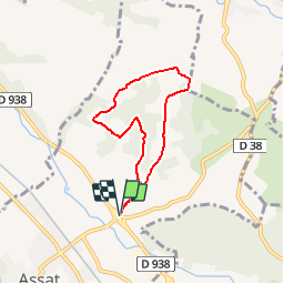
Trail Walking of 5.9 km to be discovered at New Aquitaine, Pyrénées-Atlantiques, Assat. This trail is proposed by tracegps.
Description
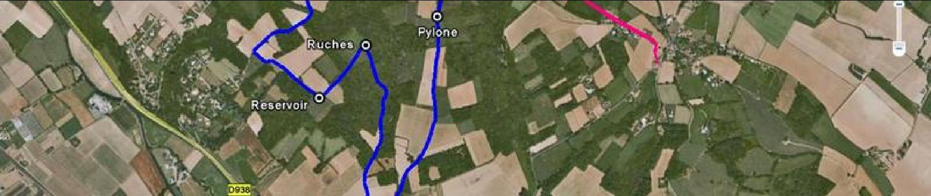
Belvédère praticable en toute saison, avec une très belle vue sur la chaîne des Pyrénées. Seule difficulté : une montée un peu raide en début de circuit. Pour s'y rendre en voiture, prendre la D938 entre Pau et Nay et se garer au niveau de la bretelle de sortie vers Assat, en contrebas du pont.
Positioning
Comments
Trails nearby
![Trail Walking Rontignon - Coteaux de Rontignon - Photo](https://media.geolcdn.com/t/375/260/ext.jpg?maxdim=2&url=https%3A%2F%2Fservices.sitytrail.com%2FGeolivesWS%2FDownloadMedia.ashx%3FTrailID%3D103073%26Media%3D4763_4.jpg)
![Walking Walking](https://static1.geolcdn.com/sitytour/trail-icons/101.png)
Walking
![](/images/other/stat-length.png)
![](https://static1.geolcdn.com/siteimages/upload/files/16400158638029165_repeat_loop_refresh_sync_direction_icon.png)
![Trail Walking Assat - BALISAGE GR 782 OUSSE / PONT DU14 JUILLET le 4/04/2023](https://media.geolcdn.com/t/375/260/eb1c9c16-be7e-4360-bd65-bc0bfd1108bb.jpg&format=jpg&maxdim=2)
![Walking Walking](https://static1.geolcdn.com/sitytour/trail-icons/101.png)
Walking
![](/images/other/stat-length.png)
![](https://static1.geolcdn.com/siteimages/upload/files/16400158638029165_repeat_loop_refresh_sync_direction_icon.png)
![Trail Walking Bizanos - BIZANOS RANDONNÉE PATRIMOINE 2868740 - Photo](https://media.geolcdn.com/t/375/260/213837b0-04be-4f10-8a02-95ffa46e349c.jpg&format=jpg&maxdim=2)
![Walking Walking](https://static1.geolcdn.com/sitytour/trail-icons/101.png)
Walking
![](/images/other/stat-length.png)
![](https://static1.geolcdn.com/siteimages/upload/files/16400158638029165_repeat_loop_refresh_sync_direction_icon.png)
![Trail Walking Assat - OUSSE a la rencontre de Cesar M2 - Photo](https://media.geolcdn.com/t/375/260/be0f19de-b432-4b6e-a08d-e17178e1c230.jpg&format=jpg&maxdim=2)
![Walking Walking](https://static1.geolcdn.com/sitytour/trail-icons/101.png)
Walking
![](/images/other/stat-length.png)
![](https://static1.geolcdn.com/siteimages/upload/files/16400158638029165_repeat_loop_refresh_sync_direction_icon.png)
![Trail Walking Rontignon - RONTIGNON le chemin des crêtes M2 fait 2644181 - Photo](https://media.geolcdn.com/t/375/260/797f6c13-d1f6-445b-af12-f454d456b125.jpg&format=jpg&maxdim=2)
![Walking Walking](https://static1.geolcdn.com/sitytour/trail-icons/101.png)
Walking
![](/images/other/stat-length.png)
![](https://static1.geolcdn.com/siteimages/upload/files/16400158638029165_repeat_loop_refresh_sync_direction_icon.png)
![Trail Walking Uzos - UZOS la boucle de la glandee balisee le 29 07 20 - Photo](https://media.geolcdn.com/t/375/260/e45bec67-f808-4c2a-b223-22164fa7db06.jpg&format=jpg&maxdim=2)
![Walking Walking](https://static1.geolcdn.com/sitytour/trail-icons/101.png)
Walking
![](/images/other/stat-length.png)
![](https://static1.geolcdn.com/siteimages/upload/files/16400158638029165_repeat_loop_refresh_sync_direction_icon.png)
![Trail Walking Idron - IDRON Deconfinement seul - Photo](https://media.geolcdn.com/t/375/260/c0185c73-9332-4a95-b3e0-d63027a94adb.jpg&format=jpg&maxdim=2)
![Walking Walking](https://static1.geolcdn.com/sitytour/trail-icons/101.png)
Walking
![](/images/other/stat-length.png)
![](https://static1.geolcdn.com/siteimages/upload/files/16400158638029165_repeat_loop_refresh_sync_direction_icon.png)
![Trail Walking Idron - IDRON confinement 33 eme - Photo](https://media.geolcdn.com/t/375/260/ec2df528-9a3a-4b62-ac63-ea639520db62.jpg&format=jpg&maxdim=2)
![Walking Walking](https://static1.geolcdn.com/sitytour/trail-icons/101.png)
Walking
![](/images/other/stat-length.png)
![](https://static1.geolcdn.com/siteimages/upload/files/16400158638029165_repeat_loop_refresh_sync_direction_icon.png)
![Trail Walking Idron - IDRON confinement (32eme) - Photo](https://media.geolcdn.com/t/375/260/6669185c-9d5a-4b54-9cbb-9f4ce8afc53a.jpg&format=jpg&maxdim=2)
![Walking Walking](https://static1.geolcdn.com/sitytour/trail-icons/101.png)
Walking
![](/images/other/stat-length.png)
![](https://static1.geolcdn.com/siteimages/upload/files/16400158638029165_repeat_loop_refresh_sync_direction_icon.png)