![](/images/other/stat-length.png)
![Trail Mountain bike Billom - Autour de Bongheat - Photo](https://media.geolcdn.com/t/1900/400/ext.pjpeg?maxdim=2&url=https%3A%2F%2Fservices.sitytrail.com%2FGeolivesWS%2FDownloadMedia.ashx%3FTrailID%3D103055%26Media%3D4675_6.jpg)
Autour de Bongheat
tracegps
User
![Length](/images/other/stat-length.png)
Length
31 km
![Max alt](https://static1.geolcdn.com/siteimages/upload/files/1508320355ic_sort_altitude_max_24dp.png)
Max alt
619 m
![Uphill gradient](https://static1.geolcdn.com/siteimages/upload/files/1508320355ic_sort_den_pos_24dp.png)
Uphill gradient
645 m
![Km-Effort](/images/other/stat-length.png)
Km-Effort
40 km
![Min alt](https://static1.geolcdn.com/siteimages/upload/files/1508320355ic_sort_altitude_min_24dp.png)
Min alt
347 m
![Downhill gradient](https://static1.geolcdn.com/siteimages/upload/files/1508320355ic_sort_den_neg_24dp.png)
Downhill gradient
650 m
![Boucle](https://static1.geolcdn.com/siteimages/upload/files/16400158638029165_repeat_loop_refresh_sync_direction_icon.png)
Boucle
No
Creation date :
2014-12-10 00:00:00.0
Updated on :
2014-12-10 00:00:00.0
![Mountain bike](https://static1.geolcdn.com/sitytour/trail-icons/202.png)
3h30
Difficulty : Difficult
![Scan this QR Code to open this trail in the SityTrail application](https://capi.geolives.com/qq0zvz2zws4bq2lad0pu/sitytour/trails/103055/qr.png?size=200)
FREE GPS app for hiking
About
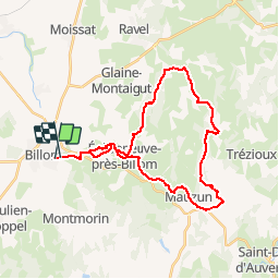
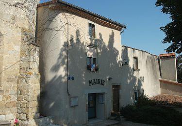
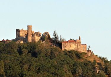
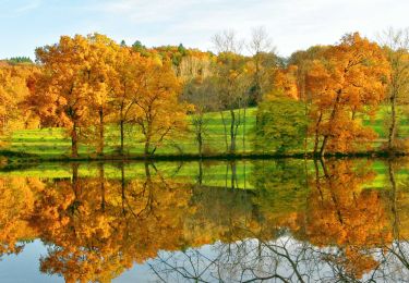
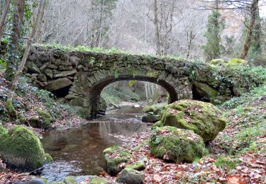
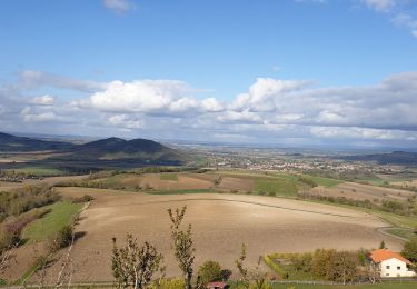
Trail Mountain bike of 31 km to be discovered at Auvergne-Rhône-Alpes, Puy-de-Dôme, Billom. This trail is proposed by tracegps.
Description
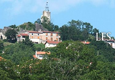
Au départ de Billom en passant par Eglise Neuve près Billom, Mauzun et Neuville: Aux portes du Livradois Forez. Voir la description ICI.
Positioning
Country:
France
Region :
Auvergne-Rhône-Alpes
Department/Province :
Puy-de-Dôme
Municipality :
Billom
Location:
Unknown
Start:(Dec)
Start:(UTM)
526984 ; 5063065 (31T) N.
Comments
Trails nearby
![Trail On foot Égliseneuve-près-Billom - Egliseneuve-près-Billom - Saint-Jean-des-Ollières - Photo](https://media.geolcdn.com/t/375/260/37c6e52b-d429-4f79-ab40-81ca434effbe.jpeg&format=jpg&maxdim=2)
![On foot On foot](https://static1.geolcdn.com/sitytour/trail-icons/100.png)
Egliseneuve-près-Billom - Saint-Jean-des-Ollières
On foot
Medium
Égliseneuve-près-Billom,
Auvergne-Rhône-Alpes,
Puy-de-Dôme,
France
![](/images/other/stat-length.png)
21 km | 30 km-effort
6h 47min
![](https://static1.geolcdn.com/siteimages/upload/files/16400158638029165_repeat_loop_refresh_sync_direction_icon.png)
No
![Trail On foot Billom - Le Turluron - Photo](https://media.geolcdn.com/t/375/260/04f9185b-8c18-47a2-9818-7864122e3458.jpeg&format=jpg&maxdim=2)
![On foot On foot](https://static1.geolcdn.com/sitytour/trail-icons/100.png)
Le Turluron
On foot
Easy
Billom,
Auvergne-Rhône-Alpes,
Puy-de-Dôme,
France
![](/images/other/stat-length.png)
7.8 km | 10.6 km-effort
2h 24min
![](https://static1.geolcdn.com/siteimages/upload/files/16400158638029165_repeat_loop_refresh_sync_direction_icon.png)
No
![Trail Walking Fayet-le-Château - Ronde des fours - Photo](https://media.geolcdn.com/t/375/260/e433297a-3dcb-40fe-9fd1-fddeffe80b31.jpg&format=jpg&maxdim=2)
![Walking Walking](https://static1.geolcdn.com/sitytour/trail-icons/101.png)
Ronde des fours
Walking
Easy
Fayet-le-Château,
Auvergne-Rhône-Alpes,
Puy-de-Dôme,
France
![](/images/other/stat-length.png)
17.1 km | 23 km-effort
5h 17min
![](https://static1.geolcdn.com/siteimages/upload/files/16400158638029165_repeat_loop_refresh_sync_direction_icon.png)
Yes
![Trail On foot Reignat - La Butte de Montaigut - Photo](https://media.geolcdn.com/t/375/260/f8dc19cd-748b-4121-b117-19288ea2e102.jpeg&format=jpg&maxdim=2)
![On foot On foot](https://static1.geolcdn.com/sitytour/trail-icons/100.png)
La Butte de Montaigut
On foot
Easy
Reignat,
Auvergne-Rhône-Alpes,
Puy-de-Dôme,
France
![](/images/other/stat-length.png)
6.3 km | 8.6 km-effort
1h 57min
![](https://static1.geolcdn.com/siteimages/upload/files/16400158638029165_repeat_loop_refresh_sync_direction_icon.png)
No
![Walking Walking](https://static1.geolcdn.com/sitytour/trail-icons/101.png)
Billom_Montmorin
Walking
Medium
(1)
Billom,
Auvergne-Rhône-Alpes,
Puy-de-Dôme,
France
![](/images/other/stat-length.png)
12.6 km | 17 km-effort
3h 45min
![](https://static1.geolcdn.com/siteimages/upload/files/16400158638029165_repeat_loop_refresh_sync_direction_icon.png)
Yes
![Trail Walking Montmorin - Montmorin_Etang_Maures - Photo](https://media.geolcdn.com/t/375/260/9684461b-8979-45bc-9377-dce9ee78b866.jpg&format=jpg&maxdim=2)
![Walking Walking](https://static1.geolcdn.com/sitytour/trail-icons/101.png)
Montmorin_Etang_Maures
Walking
Easy
Montmorin,
Auvergne-Rhône-Alpes,
Puy-de-Dôme,
France
![](/images/other/stat-length.png)
5.7 km | 8.2 km-effort
1h 43min
![](https://static1.geolcdn.com/siteimages/upload/files/16400158638029165_repeat_loop_refresh_sync_direction_icon.png)
Yes
![Trail Walking Égliseneuve-près-Billom - Egliseneuve_Madet - Photo](https://media.geolcdn.com/t/375/260/477f218d-f91e-41b8-b984-1f348fbfff5f.jpg&format=jpg&maxdim=2)
![Walking Walking](https://static1.geolcdn.com/sitytour/trail-icons/101.png)
Egliseneuve_Madet
Walking
Medium
Égliseneuve-près-Billom,
Auvergne-Rhône-Alpes,
Puy-de-Dôme,
France
![](/images/other/stat-length.png)
8.1 km | 12.1 km-effort
2h 30min
![](https://static1.geolcdn.com/siteimages/upload/files/16400158638029165_repeat_loop_refresh_sync_direction_icon.png)
Yes
![Trail Walking Saint-Julien-de-Coppel - St julien de Coppel_T - Photo](https://media.geolcdn.com/t/375/260/659f9ce3-6dc3-47cd-a576-4984fab99dab.jpg&format=jpg&maxdim=2)
![Walking Walking](https://static1.geolcdn.com/sitytour/trail-icons/101.png)
St julien de Coppel_T
Walking
Easy
Saint-Julien-de-Coppel,
Auvergne-Rhône-Alpes,
Puy-de-Dôme,
France
![](/images/other/stat-length.png)
14.2 km | 19.9 km-effort
3h 44min
![](https://static1.geolcdn.com/siteimages/upload/files/16400158638029165_repeat_loop_refresh_sync_direction_icon.png)
Yes
![Trail Walking Chas - Chas_Forts_Villageois - Photo](https://media.geolcdn.com/t/375/260/69840324-aaf6-4b2c-be10-fd95df00fcc9.jpg&format=jpg&maxdim=2)
![Walking Walking](https://static1.geolcdn.com/sitytour/trail-icons/101.png)
Chas_Forts_Villageois
Walking
Medium
Chas,
Auvergne-Rhône-Alpes,
Puy-de-Dôme,
France
![](/images/other/stat-length.png)
8.6 km | 10.2 km-effort
2h 19min
![](https://static1.geolcdn.com/siteimages/upload/files/16400158638029165_repeat_loop_refresh_sync_direction_icon.png)
Yes