![](/images/other/stat-length.png)
![Trail Mountain bike Bagnoles-de-l'Orne-Normandie - Trans'Andaines 2008 - Photo](https://media.geolcdn.com/t/1900/400/ext.pjpeg?maxdim=2&url=https%3A%2F%2Fstatic1.geolcdn.com%2Fsiteimages%2Fupload%2Ffiles%2F1524743154velo.jpg)
Trans'Andaines 2008
tracegps
User
![Length](/images/other/stat-length.png)
Length
37 km
![Max alt](https://static1.geolcdn.com/siteimages/upload/files/1508320355ic_sort_altitude_max_24dp.png)
Max alt
310 m
![Uphill gradient](https://static1.geolcdn.com/siteimages/upload/files/1508320355ic_sort_den_pos_24dp.png)
Uphill gradient
611 m
![Km-Effort](/images/other/stat-length.png)
Km-Effort
45 km
![Min alt](https://static1.geolcdn.com/siteimages/upload/files/1508320355ic_sort_altitude_min_24dp.png)
Min alt
186 m
![Downhill gradient](https://static1.geolcdn.com/siteimages/upload/files/1508320355ic_sort_den_neg_24dp.png)
Downhill gradient
607 m
![Boucle](https://static1.geolcdn.com/siteimages/upload/files/16400158638029165_repeat_loop_refresh_sync_direction_icon.png)
Boucle
Yes
Creation date :
2014-12-10 00:00:00.0
Updated on :
2014-12-10 00:00:00.0
![Mountain bike](https://static1.geolcdn.com/sitytour/trail-icons/202.png)
2h30
Difficulty : Medium
![Scan this QR Code to open this trail in the SityTrail application](https://capi.geolives.com/qq0zvz2zws4bq2lad0pu/sitytour/trails/102983/qr.png?size=200)
FREE GPS app for hiking
About
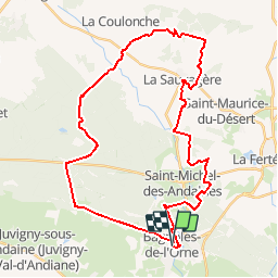
Trail Mountain bike of 37 km to be discovered at Normandy, Orne, Bagnoles-de-l'Orne-Normandie. This trail is proposed by tracegps.
Description
Rando VTT Trans'Andaines 2008 : Départ au château de Tessey La Madelaine. Boucle principalement en forêt d'Andaines et autour de La Sauvagère.
Positioning
Country:
France
Region :
Normandy
Department/Province :
Orne
Municipality :
Bagnoles-de-l'Orne-Normandie
Location:
Bagnoles-de-l'Orne
Start:(Dec)
Start:(UTM)
690169 ; 5381042 (30U) N.
Comments
Trails nearby
![Trail On foot Rives-d'Andaine - Sentier des Templiers - Photo](https://media.geolcdn.com/t/375/260/7f8f2913-590f-4c31-b4e9-64954dd46906.jpeg&format=jpg&maxdim=2)
![On foot On foot](https://static1.geolcdn.com/sitytour/trail-icons/100.png)
Sentier des Templiers
On foot
Easy
Rives-d'Andaine,
Normandy,
Orne,
France
![](/images/other/stat-length.png)
4.9 km | 6.2 km-effort
1h 23min
![](https://static1.geolcdn.com/siteimages/upload/files/16400158638029165_repeat_loop_refresh_sync_direction_icon.png)
No
![Trail Walking Bagnoles-de-l'Orne-Normandie - Saint Ortaire - Photo](https://media.geolcdn.com/t/375/260/ext.jpg?maxdim=2&url=https%3A%2F%2Fstatic1.geolcdn.com%2Fsiteimages%2Fupload%2Ffiles%2F1553511878bg_sport_marche.png)
![Walking Walking](https://static1.geolcdn.com/sitytour/trail-icons/101.png)
Saint Ortaire
Walking
Difficult
(1)
Bagnoles-de-l'Orne-Normandie,
Normandy,
Orne,
France
![](/images/other/stat-length.png)
5.5 km | 6.9 km-effort
1h 39min
![](https://static1.geolcdn.com/siteimages/upload/files/16400158638029165_repeat_loop_refresh_sync_direction_icon.png)
Yes
![Trail Walking Bagnoles-de-l'Orne-Normandie - Forêt d'Andaine - Photo](https://media.geolcdn.com/t/375/260/4445009f-5e34-4cf0-9270-1184d385e215.jpg&format=jpg&maxdim=2)
![Walking Walking](https://static1.geolcdn.com/sitytour/trail-icons/101.png)
Forêt d'Andaine
Walking
Easy
Bagnoles-de-l'Orne-Normandie,
Normandy,
Orne,
France
![](/images/other/stat-length.png)
3.6 km | 4.2 km-effort
2h 0min
![](https://static1.geolcdn.com/siteimages/upload/files/16400158638029165_repeat_loop_refresh_sync_direction_icon.png)
No
![Trail On foot Bagnoles-de-l'Orne-Normandie - Les Arbres remarquables de Bagnoles-de-l'Orne - Photo](https://media.geolcdn.com/t/375/260/3f5af4f6-b5c2-468d-a381-1ea1dcd7f8d4.jpeg&format=jpg&maxdim=2)
![On foot On foot](https://static1.geolcdn.com/sitytour/trail-icons/100.png)
Les Arbres remarquables de Bagnoles-de-l'Orne
On foot
Easy
Bagnoles-de-l'Orne-Normandie,
Normandy,
Orne,
France
![](/images/other/stat-length.png)
7.7 km | 9 km-effort
2h 2min
![](https://static1.geolcdn.com/siteimages/upload/files/16400158638029165_repeat_loop_refresh_sync_direction_icon.png)
Yes
![Trail On foot Bagnoles-de-l'Orne-Normandie - Bagnoles-de-l'Orne - Photo](https://media.geolcdn.com/t/375/260/352c0479-80dd-4a7d-ade5-52d7e1895bb3.jpeg&format=jpg&maxdim=2)
![On foot On foot](https://static1.geolcdn.com/sitytour/trail-icons/100.png)
Bagnoles-de-l'Orne
On foot
Easy
Bagnoles-de-l'Orne-Normandie,
Normandy,
Orne,
France
![](/images/other/stat-length.png)
8.2 km | 9.7 km-effort
2h 11min
![](https://static1.geolcdn.com/siteimages/upload/files/16400158638029165_repeat_loop_refresh_sync_direction_icon.png)
No
![Trail On foot La Ferté-Macé - Circuit des Bornes Cavalières - Photo](https://media.geolcdn.com/t/375/260/ae4572a0-be41-42e4-9cb7-abcf5f5905ac.jpeg&format=jpg&maxdim=2)
![On foot On foot](https://static1.geolcdn.com/sitytour/trail-icons/100.png)
Circuit des Bornes Cavalières
On foot
Easy
La Ferté-Macé,
Normandy,
Orne,
France
![](/images/other/stat-length.png)
8 km | 9.5 km-effort
2h 10min
![](https://static1.geolcdn.com/siteimages/upload/files/16400158638029165_repeat_loop_refresh_sync_direction_icon.png)
No
![Trail Hybrid bike Bagnoles-de-l'Orne-Normandie - bagnoles de l'ore - Photo](https://media.geolcdn.com/t/375/260/4eea9336-edc2-458e-9d5f-3a5eced18dc8.jpg&format=jpg&maxdim=2)
![Hybrid bike Hybrid bike](https://static1.geolcdn.com/sitytour/trail-icons/203.png)
bagnoles de l'ore
Hybrid bike
Easy
Bagnoles-de-l'Orne-Normandie,
Normandy,
Orne,
France
![](/images/other/stat-length.png)
18.6 km | 22 km-effort
1h 41min
![](https://static1.geolcdn.com/siteimages/upload/files/16400158638029165_repeat_loop_refresh_sync_direction_icon.png)
Yes
![Trail Walking Magny-le-Désert - Andaines - Villiers - Photo](https://media.geolcdn.com/t/375/260/ext.jpg?maxdim=2&url=https%3A%2F%2Fstatic1.geolcdn.com%2Fsiteimages%2Fupload%2Ffiles%2F1553511878bg_sport_marche.png)
![Walking Walking](https://static1.geolcdn.com/sitytour/trail-icons/101.png)
Andaines - Villiers
Walking
Medium
(1)
Magny-le-Désert,
Normandy,
Orne,
France
![](/images/other/stat-length.png)
10.6 km | 13.6 km-effort
2h 36min
![](https://static1.geolcdn.com/siteimages/upload/files/16400158638029165_repeat_loop_refresh_sync_direction_icon.png)
Yes
![Trail Walking Bagnoles-de-l'Orne-Normandie - Bagnoles de l' orne - Photo](https://media.geolcdn.com/t/375/260/fa0660f3-37d7-48ea-8a93-ad724fc5fdf8.jpg&format=jpg&maxdim=2)
![Walking Walking](https://static1.geolcdn.com/sitytour/trail-icons/101.png)
Bagnoles de l' orne
Walking
Very easy
Bagnoles-de-l'Orne-Normandie,
Normandy,
Orne,
France
![](/images/other/stat-length.png)
4.8 km | 6.1 km-effort
1h 49min
![](https://static1.geolcdn.com/siteimages/upload/files/16400158638029165_repeat_loop_refresh_sync_direction_icon.png)
Yes