


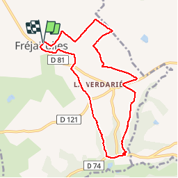

7.6 km | 9.9 km-effort


User


FREE GPS app for hiking
 SityTrail
IGN / Geographical institutes
SityTrail World
The world is yours!
Trail Walking of 9.4 km to be discovered at Occitania, Tarn, Fréjairolles. This trail is proposed by jpipacific.
Randonnée plutôt jolie avec alternance de sous bois, de points de vue dominants, de chemins et de petites routes. A noter: Pas de chien qui aboie tout le long de la randonnée. Chemin bien balisé.
Walking
Walking

Road bike


sport
Road bike

Walking
Walking
Cycle
Walking