![](/images/other/stat-length.png)
![Trail Walking Saint-Prix - Béthemont la Forêt - Photo](https://media.geolcdn.com/t/1900/400/ext.pjpeg?maxdim=2&url=https%3A%2F%2Fstatic1.geolcdn.com%2Fsiteimages%2Fupload%2Ffiles%2F1553511878bg_sport_marche.png)
Béthemont la Forêt
tracegps
User
![Length](/images/other/stat-length.png)
Length
8.9 km
![Max alt](https://static1.geolcdn.com/siteimages/upload/files/1508320355ic_sort_altitude_max_24dp.png)
Max alt
200 m
![Uphill gradient](https://static1.geolcdn.com/siteimages/upload/files/1508320355ic_sort_den_pos_24dp.png)
Uphill gradient
195 m
![Km-Effort](/images/other/stat-length.png)
Km-Effort
11.5 km
![Min alt](https://static1.geolcdn.com/siteimages/upload/files/1508320355ic_sort_altitude_min_24dp.png)
Min alt
128 m
![Downhill gradient](https://static1.geolcdn.com/siteimages/upload/files/1508320355ic_sort_den_neg_24dp.png)
Downhill gradient
195 m
![Boucle](https://static1.geolcdn.com/siteimages/upload/files/16400158638029165_repeat_loop_refresh_sync_direction_icon.png)
Boucle
Yes
Creation date :
2014-12-10 00:00:00.0
Updated on :
2014-12-10 00:00:00.0
![Walking](https://static1.geolcdn.com/sitytour/trail-icons/101.png)
3h00
Difficulty : Medium
![Scan this QR Code to open this trail in the SityTrail application](https://capi.geolives.com/qq0zvz2zws4bq2lad0pu/sitytour/trails/102957/qr.png?size=200)
FREE GPS app for hiking
About
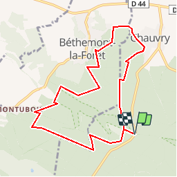
Trail Walking of 8.9 km to be discovered at Ile-de-France, Val-d'Oise, Saint-Prix. This trail is proposed by tracegps.
Description
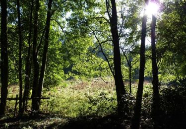
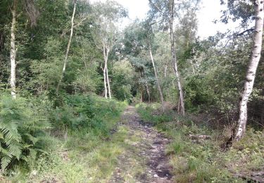
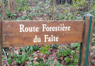
Départ et arrivée au parking du "faisan doré" sur la route de Chauvry. Passage par Chauvry et sur les hauteurs de Bethemont avant de revenir vers le parking. Promenade en sous-bois avec quelques passages très boueux.
Positioning
Country:
France
Region :
Ile-de-France
Department/Province :
Val-d'Oise
Municipality :
Saint-Prix
Location:
Unknown
Start:(Dec)
Start:(UTM)
446155 ; 5432009 (31U) N.
Comments
Trails nearby
![Trail Walking Frépillon - GRP CV-IDF 2023 - Photo](https://media.geolcdn.com/t/375/260/cd8022c7-e75e-42b2-b52b-fdfab1f12efc.jpg&format=jpg&maxdim=2)
![Walking Walking](https://static1.geolcdn.com/sitytour/trail-icons/101.png)
GRP CV-IDF 2023
Walking
Very difficult
(1)
Frépillon,
Ile-de-France,
Val-d'Oise,
France
![](/images/other/stat-length.png)
16 km | 20 km-effort
4h 32min
![](https://static1.geolcdn.com/siteimages/upload/files/16400158638029165_repeat_loop_refresh_sync_direction_icon.png)
No
![Trail Mountain bike Taverny - La Tabernacienne 2013 - Taverny - Photo](https://media.geolcdn.com/t/375/260/ext.jpg?maxdim=2&url=https%3A%2F%2Fservices.sitytrail.com%2FGeolivesWS%2FDownloadMedia.ashx%3FTrailID%3D191578%26Media%3D15203_6.jpg)
![Mountain bike Mountain bike](https://static1.geolcdn.com/sitytour/trail-icons/202.png)
La Tabernacienne 2013 - Taverny
Mountain bike
Medium
(1)
Taverny,
Ile-de-France,
Val-d'Oise,
France
![](/images/other/stat-length.png)
32 km | 39 km-effort
2h 30min
![](https://static1.geolcdn.com/siteimages/upload/files/16400158638029165_repeat_loop_refresh_sync_direction_icon.png)
Yes
![Trail Walking Taverny - Boucle en forêt à partir de Taverny - Photo](https://media.geolcdn.com/t/375/260/ext.jpg?maxdim=2&url=https%3A%2F%2Fservices.sitytrail.com%2FGeolivesWS%2FDownloadMedia.ashx%3FTrailID%3D106699%26Media%3D11336_3.jpg)
![Walking Walking](https://static1.geolcdn.com/sitytour/trail-icons/101.png)
Boucle en forêt à partir de Taverny
Walking
Medium
(1)
Taverny,
Ile-de-France,
Val-d'Oise,
France
![](/images/other/stat-length.png)
12.3 km | 15.8 km-effort
3h 30min
![](https://static1.geolcdn.com/siteimages/upload/files/16400158638029165_repeat_loop_refresh_sync_direction_icon.png)
Yes
![Trail Equestrian Taverny - Rando testé Montmorency l'isle adam 23km - Photo](https://media.geolcdn.com/t/375/260/ext.jpg?maxdim=2&url=https%3A%2F%2Fstatic1.geolcdn.com%2Fsiteimages%2Fupload%2Ffiles%2F1524743154cheval.jpg)
![Equestrian Equestrian](https://static1.geolcdn.com/sitytour/trail-icons/300.png)
Rando testé Montmorency l'isle adam 23km
Equestrian
Medium
(2)
Taverny,
Ile-de-France,
Val-d'Oise,
France
![](/images/other/stat-length.png)
25 km | 31 km-effort
3h 51min
![](https://static1.geolcdn.com/siteimages/upload/files/16400158638029165_repeat_loop_refresh_sync_direction_icon.png)
Yes
![Trail Mountain bike Saint-Leu-la-Forêt - Montmorency - Photo](https://media.geolcdn.com/t/375/260/ext.jpg?maxdim=2&url=https%3A%2F%2Fstatic1.geolcdn.com%2Fsiteimages%2Fupload%2Ffiles%2F1524743154velo.jpg)
![Mountain bike Mountain bike](https://static1.geolcdn.com/sitytour/trail-icons/202.png)
Montmorency
Mountain bike
Medium
(2)
Saint-Leu-la-Forêt,
Ile-de-France,
Val-d'Oise,
France
![](/images/other/stat-length.png)
23 km | 30 km-effort
Unknown
![](https://static1.geolcdn.com/siteimages/upload/files/16400158638029165_repeat_loop_refresh_sync_direction_icon.png)
Yes
![Trail Walking Villiers-Adam - Villiers Adam - Photo](https://media.geolcdn.com/t/375/260/ed080b68-c869-473e-8e17-09c21255ad1c.jpg&format=jpg&maxdim=2)
![Walking Walking](https://static1.geolcdn.com/sitytour/trail-icons/101.png)
Villiers Adam
Walking
Medium
Villiers-Adam,
Ile-de-France,
Val-d'Oise,
France
![](/images/other/stat-length.png)
8.2 km | 10.2 km-effort
1h 57min
![](https://static1.geolcdn.com/siteimages/upload/files/16400158638029165_repeat_loop_refresh_sync_direction_icon.png)
Yes
![Trail Walking Chauvry - Foutue route vers Baillet - Photo](https://media.geolcdn.com/t/375/260/ext.jpg?maxdim=2&url=https%3A%2F%2Fstatic1.geolcdn.com%2Fsiteimages%2Fupload%2Ffiles%2F1553511878bg_sport_marche.png)
![Walking Walking](https://static1.geolcdn.com/sitytour/trail-icons/101.png)
Foutue route vers Baillet
Walking
Medium
(1)
Chauvry,
Ile-de-France,
Val-d'Oise,
France
![](/images/other/stat-length.png)
19.1 km | 24 km-effort
5h 20min
![](https://static1.geolcdn.com/siteimages/upload/files/16400158638029165_repeat_loop_refresh_sync_direction_icon.png)
Yes
![Trail Walking Mériel - Meriel Villierrs Adam - Photo](https://media.geolcdn.com/t/375/260/c2a0a3e3-f2a3-4c00-b07c-627fe0936e05.jpg&format=jpg&maxdim=2)
![Walking Walking](https://static1.geolcdn.com/sitytour/trail-icons/101.png)
Meriel Villierrs Adam
Walking
Very easy
Mériel,
Ile-de-France,
Val-d'Oise,
France
![](/images/other/stat-length.png)
14.1 km | 17.2 km-effort
3h 29min
![](https://static1.geolcdn.com/siteimages/upload/files/16400158638029165_repeat_loop_refresh_sync_direction_icon.png)
Yes
![Trail Walking Frépillon - FREPILLON > PARMAIN 18 KM - Photo](https://media.geolcdn.com/t/375/260/ext.jpg?maxdim=2&url=https%3A%2F%2Fstatic1.geolcdn.com%2Fsiteimages%2Fupload%2Ffiles%2F1553511878bg_sport_marche.png)
![Walking Walking](https://static1.geolcdn.com/sitytour/trail-icons/101.png)
FREPILLON > PARMAIN 18 KM
Walking
Very difficult
(1)
Frépillon,
Ile-de-France,
Val-d'Oise,
France
![](/images/other/stat-length.png)
18 km | 21 km-effort
4h 49min
![](https://static1.geolcdn.com/siteimages/upload/files/16400158638029165_repeat_loop_refresh_sync_direction_icon.png)
No
trace juste en segment (endroits faux apres le fay)
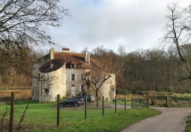
De beaux passages hors des sentiers battus ou trop fréquentés. Une halte à la ferme de Chauvry pour les chèvres et leurs fromages.