![](/images/other/stat-length.png)
![Trail Walking Lalinde - Lalinde - Baneuil - Photo](https://media.geolcdn.com/t/1900/400/ext.pjpeg?maxdim=2&url=https%3A%2F%2Fstatic1.geolcdn.com%2Fsiteimages%2Fupload%2Ffiles%2F1553511878bg_sport_marche.png)
Lalinde - Baneuil
tracegps
User
![Length](/images/other/stat-length.png)
![Max alt](https://static1.geolcdn.com/siteimages/upload/files/1508320355ic_sort_altitude_max_24dp.png)
![Uphill gradient](https://static1.geolcdn.com/siteimages/upload/files/1508320355ic_sort_den_pos_24dp.png)
![Km-Effort](/images/other/stat-length.png)
![Min alt](https://static1.geolcdn.com/siteimages/upload/files/1508320355ic_sort_altitude_min_24dp.png)
![Downhill gradient](https://static1.geolcdn.com/siteimages/upload/files/1508320355ic_sort_den_neg_24dp.png)
![Boucle](https://static1.geolcdn.com/siteimages/upload/files/16400158638029165_repeat_loop_refresh_sync_direction_icon.png)
![Walking](https://static1.geolcdn.com/sitytour/trail-icons/101.png)
2h30
Difficulty : Medium
![Scan this QR Code to open this trail in the SityTrail application](https://capi.geolives.com/qq0zvz2zws4bq2lad0pu/sitytour/trails/102939/qr.png?size=200)
FREE GPS app for hiking
About
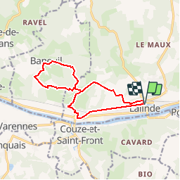
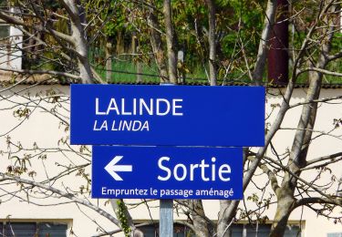
Trail Walking of 12.8 km to be discovered at New Aquitaine, Dordogne, Lalinde. This trail is proposed by tracegps.
Description
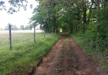
Parcours d'entraînement à difficulté variable. Échauffement sur 3,5km de plat avant côte de St Sulpice. A Les Magnacs, chemin GR en forêt jusqu'à Baneuil. Puis retour sur route jusqu'au Bailleries. Forêt avec côte jusqu'au Magnacs puis route jusqu'à Chemin Rouge. Final en forêt avec passages étriqués caillouteux. Forte montée avant redescente sur Lalinde.
Positioning
Comments
Trails nearby
![Trail On foot Bayac - Boucle du rocher du corbeau - Photo](https://media.geolcdn.com/t/375/260/a01af072-2115-4f76-b70a-38b560fb26f8.jpeg&format=jpg&maxdim=2)
![On foot On foot](https://static1.geolcdn.com/sitytour/trail-icons/100.png)
On foot
![](/images/other/stat-length.png)
![](https://static1.geolcdn.com/siteimages/upload/files/16400158638029165_repeat_loop_refresh_sync_direction_icon.png)
![Trail Road bike Lalinde - J5 Montpazier - Photo](https://media.geolcdn.com/t/375/260/fb9d0b69-e2e2-4675-8d66-fb9a6bacc3d8.jpg&format=jpg&maxdim=2)
![Road bike Road bike](https://static1.geolcdn.com/sitytour/trail-icons/201.png)
Road bike
![](/images/other/stat-length.png)
![](https://static1.geolcdn.com/siteimages/upload/files/16400158638029165_repeat_loop_refresh_sync_direction_icon.png)
![Trail Road bike Lalinde - J4 La Vézère Les Eyzies - Photo](https://media.geolcdn.com/t/375/260/d56817ab-ff5e-4eb7-9859-4a4ae1248a9d.jpg&format=jpg&maxdim=2)
![Road bike Road bike](https://static1.geolcdn.com/sitytour/trail-icons/201.png)
Road bike
![](/images/other/stat-length.png)
![](https://static1.geolcdn.com/siteimages/upload/files/16400158638029165_repeat_loop_refresh_sync_direction_icon.png)
![Trail Road bike Lalinde - J3 Rives Dordogne Bergerac - Photo](https://media.geolcdn.com/t/375/260/c8141807-4c11-44f2-beef-7451f05db207.jpg&format=jpg&maxdim=2)
![Road bike Road bike](https://static1.geolcdn.com/sitytour/trail-icons/201.png)
Road bike
![](/images/other/stat-length.png)
![](https://static1.geolcdn.com/siteimages/upload/files/16400158638029165_repeat_loop_refresh_sync_direction_icon.png)
![Trail Road bike Lalinde - J2 Bergerac et Montbazillac - Photo](https://media.geolcdn.com/t/375/260/8c3c065b-e426-4bd0-b47e-b913070b649b.jpg&format=jpg&maxdim=2)
![Road bike Road bike](https://static1.geolcdn.com/sitytour/trail-icons/201.png)
Road bike
![](/images/other/stat-length.png)
![](https://static1.geolcdn.com/siteimages/upload/files/16400158638029165_repeat_loop_refresh_sync_direction_icon.png)
![Trail On foot Couze-et-Saint-Front - Boucle de Saint-Front - Photo](https://media.geolcdn.com/t/375/260/68d660a2-8ed7-45f4-8c15-04cab9323f1e.jpeg&format=jpg&maxdim=2)
![On foot On foot](https://static1.geolcdn.com/sitytour/trail-icons/100.png)
On foot
![](/images/other/stat-length.png)
![](https://static1.geolcdn.com/siteimages/upload/files/16400158638029165_repeat_loop_refresh_sync_direction_icon.png)
![Trail Walking Lalinde - Boucle de Pontour(modifiée) - Photo](https://media.geolcdn.com/t/375/260/dfd1470c-f46a-429d-81a7-c0de5e51c4f9.jpg&format=jpg&maxdim=2)
![Walking Walking](https://static1.geolcdn.com/sitytour/trail-icons/101.png)
Walking
![](/images/other/stat-length.png)
![](https://static1.geolcdn.com/siteimages/upload/files/16400158638029165_repeat_loop_refresh_sync_direction_icon.png)
![Trail Walking Beaumontois en Périgord - boucle bannes - Photo](https://media.geolcdn.com/t/375/260/ext.jpg?maxdim=2&url=https%3A%2F%2Fservices.sitytrail.com%2FGeolivesWS%2FDownloadMedia.ashx%3FTrailID%3D332998%26Media%3Dfix__20140810111605.jpg)
![Walking Walking](https://static1.geolcdn.com/sitytour/trail-icons/101.png)
Walking
![](/images/other/stat-length.png)
![](https://static1.geolcdn.com/siteimages/upload/files/16400158638029165_repeat_loop_refresh_sync_direction_icon.png)
![Trail Walking Badefols-sur-Dordogne - Badefols Tremola Limeuil - Photo](https://media.geolcdn.com/t/375/260/ext.jpg?maxdim=2&url=https%3A%2F%2Fservices.sitytrail.com%2FGeolivesWS%2FDownloadMedia.ashx%3FTrailID%3D268029%26Media%3D20120812110708.jpeg)
![Walking Walking](https://static1.geolcdn.com/sitytour/trail-icons/101.png)
Walking
![](/images/other/stat-length.png)
![](https://static1.geolcdn.com/siteimages/upload/files/16400158638029165_repeat_loop_refresh_sync_direction_icon.png)