![](/images/other/stat-length.png)
![Trail Mountain bike Lubbon - Lubbon, au pays des lagunes oubliées - Photo](https://media.geolcdn.com/t/1900/400/ext.pjpeg?maxdim=2&url=https%3A%2F%2Fservices.sitytrail.com%2FGeolivesWS%2FDownloadMedia.ashx%3FTrailID%3D102789%26Media%3D3951_1.jpg)
Lubbon, au pays des lagunes oubliées
tracegps
User
![Length](/images/other/stat-length.png)
![Max alt](https://static1.geolcdn.com/siteimages/upload/files/1508320355ic_sort_altitude_max_24dp.png)
![Uphill gradient](https://static1.geolcdn.com/siteimages/upload/files/1508320355ic_sort_den_pos_24dp.png)
![Km-Effort](/images/other/stat-length.png)
![Min alt](https://static1.geolcdn.com/siteimages/upload/files/1508320355ic_sort_altitude_min_24dp.png)
![Downhill gradient](https://static1.geolcdn.com/siteimages/upload/files/1508320355ic_sort_den_neg_24dp.png)
![Boucle](https://static1.geolcdn.com/siteimages/upload/files/16400158638029165_repeat_loop_refresh_sync_direction_icon.png)
![Mountain bike](https://static1.geolcdn.com/sitytour/trail-icons/202.png)
3h00
Difficulty : Medium
![Scan this QR Code to open this trail in the SityTrail application](https://capi.geolives.com/qq0zvz2zws4bq2lad0pu/sitytour/trails/102789/qr.png?size=200)
FREE GPS app for hiking
About
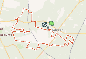
Trail Mountain bike of 32 km to be discovered at New Aquitaine, Landes, Lubbon. This trail is proposed by tracegps.
Description
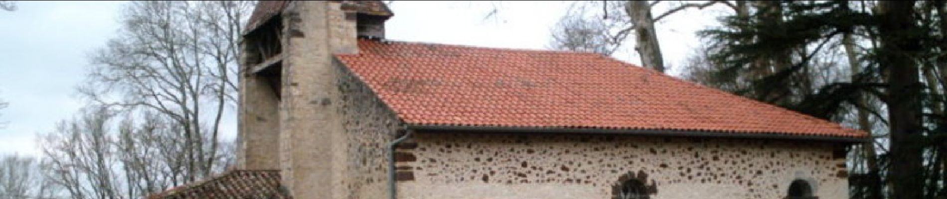
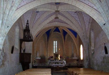
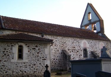
Lubbon, au pays des lagunes oubliées!! ntérêt : lagune de Roustouze, anciennes lagunes, sources du Ciron, église landaise, forêt, grues cendrées, cerf (c'est un peu avant la tombée de la nuit, que vous aurez peut-être le bonheur de croiser cet animal magestueux) Retrouvez d’autres photos et la description complète sur Ciron VTT, des circuits de randonnées VTT et traces GPS dans la vallée du Ciron (Gironde, Landes) et au-delà …
Positioning
Comments
Trails nearby
![Trail On foot Poudenas - Poudenas, une ambiance de Toscane 10.8 km - Photo](https://media.geolcdn.com/t/375/260/ef3687dd-33b2-428d-9c76-911af79325b2.jpeg&format=jpg&maxdim=2)
![On foot On foot](https://static1.geolcdn.com/sitytour/trail-icons/100.png)
On foot
![](/images/other/stat-length.png)
![](https://static1.geolcdn.com/siteimages/upload/files/16400158638029165_repeat_loop_refresh_sync_direction_icon.png)
![Trail On foot Poudenas - Poudenas, une ambiance de Toscane variante 7.8 km - Photo](https://media.geolcdn.com/t/375/260/ef3687dd-33b2-428d-9c76-911af79325b2.jpeg&format=jpg&maxdim=2)
![On foot On foot](https://static1.geolcdn.com/sitytour/trail-icons/100.png)
On foot
![](/images/other/stat-length.png)
![](https://static1.geolcdn.com/siteimages/upload/files/16400158638029165_repeat_loop_refresh_sync_direction_icon.png)
![Trail On foot Poudenas - De Mézin, la Médiévale à Poudenas, l'Italienne 14.3 km - Photo](https://media.geolcdn.com/t/375/260/4931e991-4f88-4037-bc7e-658247d6e79b.jpeg&format=jpg&maxdim=2)
![On foot On foot](https://static1.geolcdn.com/sitytour/trail-icons/100.png)
On foot
![](/images/other/stat-length.png)
![](https://static1.geolcdn.com/siteimages/upload/files/16400158638029165_repeat_loop_refresh_sync_direction_icon.png)
![Trail On foot Sos - De Sos à Poudenas sur le chemin de Gélise 17.2 km - Photo](https://media.geolcdn.com/t/375/260/ef3687dd-33b2-428d-9c76-911af79325b2.jpeg&format=jpg&maxdim=2)
![On foot On foot](https://static1.geolcdn.com/sitytour/trail-icons/100.png)
On foot
![](/images/other/stat-length.png)
![](https://static1.geolcdn.com/siteimages/upload/files/16400158638029165_repeat_loop_refresh_sync_direction_icon.png)
![Trail On foot Sauméjan - Sauméjan, vacances au « milieu de la forêt » - 9.9 km - Photo](https://media.geolcdn.com/t/375/260/7e8ffff5-1db4-4879-93a3-100007b84c67.jpeg&format=jpg&maxdim=2)
![On foot On foot](https://static1.geolcdn.com/sitytour/trail-icons/100.png)
On foot
![](/images/other/stat-length.png)
![](https://static1.geolcdn.com/siteimages/upload/files/16400158638029165_repeat_loop_refresh_sync_direction_icon.png)
![Trail On foot Pompogne - Pompogne, le clocher et le pin - 12.3 km - Photo](https://media.geolcdn.com/t/375/260/fef962c1-d5fc-4a67-8889-38c146f9717a.jpeg&format=jpg&maxdim=2)
![On foot On foot](https://static1.geolcdn.com/sitytour/trail-icons/100.png)
On foot
![](/images/other/stat-length.png)
![](https://static1.geolcdn.com/siteimages/upload/files/16400158638029165_repeat_loop_refresh_sync_direction_icon.png)
![Trail On foot Houeillès - Houeillès, dans la forêt des Lugues - 16.1 km - Photo](https://media.geolcdn.com/t/375/260/dc960556-4d92-48cf-98f9-ba4f2df05f5c.jpeg&format=jpg&maxdim=2)
![On foot On foot](https://static1.geolcdn.com/sitytour/trail-icons/100.png)
On foot
![](/images/other/stat-length.png)
![](https://static1.geolcdn.com/siteimages/upload/files/16400158638029165_repeat_loop_refresh_sync_direction_icon.png)
![Trail On foot Houeillès - Houeillès, balade en forêt - 9.4 km - Photo](https://media.geolcdn.com/t/375/260/dc960556-4d92-48cf-98f9-ba4f2df05f5c.jpeg&format=jpg&maxdim=2)
![On foot On foot](https://static1.geolcdn.com/sitytour/trail-icons/100.png)
On foot
![](/images/other/stat-length.png)
![](https://static1.geolcdn.com/siteimages/upload/files/16400158638029165_repeat_loop_refresh_sync_direction_icon.png)
![Trail On foot Allons - Allons, en Forêt et sur une Ancienne Voie Ferrée - 20.7 km - Photo](https://media.geolcdn.com/t/375/260/74fd1a10-2e67-416a-9ca8-8d8f7e180993.jpeg&format=jpg&maxdim=2)
![On foot On foot](https://static1.geolcdn.com/sitytour/trail-icons/100.png)
On foot
![](/images/other/stat-length.png)
![](https://static1.geolcdn.com/siteimages/upload/files/16400158638029165_repeat_loop_refresh_sync_direction_icon.png)