![](/images/other/stat-length.png)
![Trail Mountain bike Beaumont-du-Ventoux - Montee Nord Ventoux - Photo](https://media.geolcdn.com/t/1900/400/ext.pjpeg?maxdim=2&url=https%3A%2F%2Fstatic1.geolcdn.com%2Fsiteimages%2Fupload%2Ffiles%2F1524743154velo.jpg)
Montee Nord Ventoux
tracegps
User
![Length](/images/other/stat-length.png)
Length
26 km
![Max alt](https://static1.geolcdn.com/siteimages/upload/files/1508320355ic_sort_altitude_max_24dp.png)
Max alt
1434 m
![Uphill gradient](https://static1.geolcdn.com/siteimages/upload/files/1508320355ic_sort_den_pos_24dp.png)
Uphill gradient
86 m
![Km-Effort](/images/other/stat-length.png)
Km-Effort
31 km
![Min alt](https://static1.geolcdn.com/siteimages/upload/files/1508320355ic_sort_altitude_min_24dp.png)
Min alt
203 m
![Downhill gradient](https://static1.geolcdn.com/siteimages/upload/files/1508320355ic_sort_den_neg_24dp.png)
Downhill gradient
1300 m
![Boucle](https://static1.geolcdn.com/siteimages/upload/files/16400158638029165_repeat_loop_refresh_sync_direction_icon.png)
Boucle
No
Creation date :
2014-12-10 00:00:00.0
Updated on :
2014-12-10 00:00:00.0
![Mountain bike](https://static1.geolcdn.com/sitytour/trail-icons/202.png)
3h00
Difficulty : Difficult
![Scan this QR Code to open this trail in the SityTrail application](https://capi.geolives.com/qq0zvz2zws4bq2lad0pu/sitytour/trails/102755/qr.png?size=200)
FREE GPS app for hiking
About
Trail Mountain bike of 26 km to be discovered at Provence-Alpes-Côte d'Azur, Vaucluse, Beaumont-du-Ventoux. This trail is proposed by tracegps.
Description
C’est un tracé que j’ai créé sur Mapsource, je le fais bientôt et je mettrais par la suite la trace donne par le gps...
Positioning
Country:
France
Region :
Provence-Alpes-Côte d'Azur
Department/Province :
Vaucluse
Municipality :
Beaumont-du-Ventoux
Location:
Unknown
Start:(Dec)
Start:(UTM)
680554 ; 4894467 (31T) N.
Comments
Trails nearby
![Trail Walking Bédoin - DEMOISELLES COIFFEES A BEDOIN - Photo](https://media.geolcdn.com/t/375/260/019fb321-209a-41dd-ae41-5842e06d9c3c.jpg&format=jpg&maxdim=2)
![Walking Walking](https://static1.geolcdn.com/sitytour/trail-icons/101.png)
DEMOISELLES COIFFEES A BEDOIN
Walking
Medium
(1)
Bédoin,
Provence-Alpes-Côte d'Azur,
Vaucluse,
France
![](/images/other/stat-length.png)
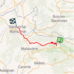
18.8 km | 25 km-effort
6h 1min
![](https://static1.geolcdn.com/siteimages/upload/files/16400158638029165_repeat_loop_refresh_sync_direction_icon.png)
Yes
![Trail Walking Beaumont-du-Ventoux - Le Ventoux - Corniche Nord - Photo](https://media.geolcdn.com/t/375/260/ext.jpg?maxdim=2&url=https%3A%2F%2Fservices.sitytrail.com%2FGeolivesWS%2FDownloadMedia.ashx%3FTrailID%3D105329%26Media%3D9023_2.jpg)
![Walking Walking](https://static1.geolcdn.com/sitytour/trail-icons/101.png)
Le Ventoux - Corniche Nord
Walking
Difficult
(2)
Beaumont-du-Ventoux,
Provence-Alpes-Côte d'Azur,
Vaucluse,
France
![](/images/other/stat-length.png)
19.1 km | 30 km-effort
6h 30min
![](https://static1.geolcdn.com/siteimages/upload/files/16400158638029165_repeat_loop_refresh_sync_direction_icon.png)
Yes
![Trail Walking Beaumont-du-Ventoux - Sentier de découverte au Mont Serein - Photo](https://media.geolcdn.com/t/375/260/ext.jpg?maxdim=2&url=https%3A%2F%2Fservices.sitytrail.com%2FGeolivesWS%2FDownloadMedia.ashx%3FTrailID%3D103767%26Media%3D6520_2.jpg)
![Walking Walking](https://static1.geolcdn.com/sitytour/trail-icons/101.png)
Sentier de découverte au Mont Serein
Walking
Medium
(2)
Beaumont-du-Ventoux,
Provence-Alpes-Côte d'Azur,
Vaucluse,
France
![](/images/other/stat-length.png)
6.3 km | 8.2 km-effort
2h 0min
![](https://static1.geolcdn.com/siteimages/upload/files/16400158638029165_repeat_loop_refresh_sync_direction_icon.png)
Yes
![Trail Walking Bédoin - Baume du Chat final par les Siarres - Photo](https://media.geolcdn.com/t/375/260/4fd782e1-4328-4855-b0d0-bdb9d12f34a6.jpg&format=jpg&maxdim=2)
![Walking Walking](https://static1.geolcdn.com/sitytour/trail-icons/101.png)
Baume du Chat final par les Siarres
Walking
Medium
Bédoin,
Provence-Alpes-Côte d'Azur,
Vaucluse,
France
![](/images/other/stat-length.png)
8.3 km | 15.6 km-effort
2h 27min
![](https://static1.geolcdn.com/siteimages/upload/files/16400158638029165_repeat_loop_refresh_sync_direction_icon.png)
Yes
![Trail Mountain bike Bédoin - Enduro Lilou Collet de Robin - Photo](https://media.geolcdn.com/t/375/260/5b277d16-82be-4683-8302-c0071eeba31c.jpg&format=jpg&maxdim=2)
![Mountain bike Mountain bike](https://static1.geolcdn.com/sitytour/trail-icons/202.png)
Enduro Lilou Collet de Robin
Mountain bike
Medium
Bédoin,
Provence-Alpes-Côte d'Azur,
Vaucluse,
France
![](/images/other/stat-length.png)
23 km | 29 km-effort
2h 1min
![](https://static1.geolcdn.com/siteimages/upload/files/16400158638029165_repeat_loop_refresh_sync_direction_icon.png)
No
![Trail Mountain bike Bédoin - Enduro les Pins Noirs - Photo](https://media.geolcdn.com/t/375/260/2664f93b-d28f-4f7e-87bb-83b490384099.jpg&format=jpg&maxdim=2)
![Mountain bike Mountain bike](https://static1.geolcdn.com/sitytour/trail-icons/202.png)
Enduro les Pins Noirs
Mountain bike
Difficult
Bédoin,
Provence-Alpes-Côte d'Azur,
Vaucluse,
France
![](/images/other/stat-length.png)
37 km | 49 km-effort
2h 55min
![](https://static1.geolcdn.com/siteimages/upload/files/16400158638029165_repeat_loop_refresh_sync_direction_icon.png)
No
![Trail Mountain bike Bédoin - Enduro ventoux Jas de Roubin - Photo](https://media.geolcdn.com/t/375/260/1373ca7b-671b-4daf-87c8-1e173f3e01d8.jpg&format=jpg&maxdim=2)
![Mountain bike Mountain bike](https://static1.geolcdn.com/sitytour/trail-icons/202.png)
Enduro ventoux Jas de Roubin
Mountain bike
Medium
Bédoin,
Provence-Alpes-Côte d'Azur,
Vaucluse,
France
![](/images/other/stat-length.png)
23 km | 30 km-effort
2h 3min
![](https://static1.geolcdn.com/siteimages/upload/files/16400158638029165_repeat_loop_refresh_sync_direction_icon.png)
No
![Trail Walking Bédoin - Les Glacières du Facteur - Photo](https://media.geolcdn.com/t/375/260/cb31eb20-4ac1-469f-8550-b7fec6b9125d.jpg&format=jpg&maxdim=2)
![Walking Walking](https://static1.geolcdn.com/sitytour/trail-icons/101.png)
Les Glacières du Facteur
Walking
Very difficult
Bédoin,
Provence-Alpes-Côte d'Azur,
Vaucluse,
France
![](/images/other/stat-length.png)
13.2 km | 21 km-effort
4h 43min
![](https://static1.geolcdn.com/siteimages/upload/files/16400158638029165_repeat_loop_refresh_sync_direction_icon.png)
Yes
![Trail Walking Bédoin - sentier du Vertige - Photo](https://media.geolcdn.com/t/375/260/537c0036-295e-4148-b1ac-658565f4196a.jpg&format=jpg&maxdim=2)
![Walking Walking](https://static1.geolcdn.com/sitytour/trail-icons/101.png)
sentier du Vertige
Walking
Difficult
Bédoin,
Provence-Alpes-Côte d'Azur,
Vaucluse,
France
![](/images/other/stat-length.png)
7.4 km | 12.3 km-effort
2h 54min
![](https://static1.geolcdn.com/siteimages/upload/files/16400158638029165_repeat_loop_refresh_sync_direction_icon.png)
Yes