![](/images/other/stat-length.png)
![Trail Mountain bike Langogne - Espace VTT FFC du Gévaudan - n°03 - Circuit des Huttes - Photo](https://media.geolcdn.com/t/1900/400/ext.pjpeg?maxdim=2&url=https%3A%2F%2Fservices.sitytrail.com%2FGeolivesWS%2FDownloadMedia.ashx%3FTrailID%3D102660%26Media%3D3669_1.jpg)
Espace VTT FFC du Gévaudan - n°03 - Circuit des Huttes
tracegps
User
![Length](/images/other/stat-length.png)
![Max alt](https://static1.geolcdn.com/siteimages/upload/files/1508320355ic_sort_altitude_max_24dp.png)
![Uphill gradient](https://static1.geolcdn.com/siteimages/upload/files/1508320355ic_sort_den_pos_24dp.png)
![Km-Effort](/images/other/stat-length.png)
![Min alt](https://static1.geolcdn.com/siteimages/upload/files/1508320355ic_sort_altitude_min_24dp.png)
![Downhill gradient](https://static1.geolcdn.com/siteimages/upload/files/1508320355ic_sort_den_neg_24dp.png)
![Boucle](https://static1.geolcdn.com/siteimages/upload/files/16400158638029165_repeat_loop_refresh_sync_direction_icon.png)
![Mountain bike](https://static1.geolcdn.com/sitytour/trail-icons/202.png)
3h15
Difficulty : Difficult
![Scan this QR Code to open this trail in the SityTrail application](https://capi.geolives.com/qq0zvz2zws4bq2lad0pu/sitytour/trails/102660/qr.png?size=200)
FREE GPS app for hiking
About
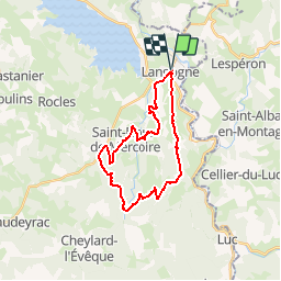
Trail Mountain bike of 25 km to be discovered at Occitania, Lozère, Langogne. This trail is proposed by tracegps.
Description
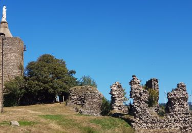
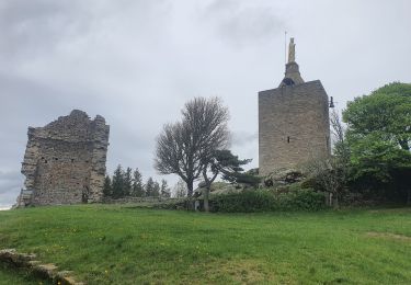
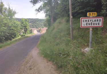
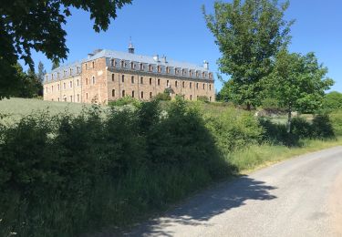
Espace VTT FFC Domaine VTT du Gévaudan Circuit labellisé par la Fédération Française de Cyclisme. Situé en plein coeur du Gévaudan, le domaine VTT s'étend sur 13 communes au départ de Langogne, du lac de Naussac au Moure de la Gardille, en passant par les gorges du Langouyrou ou de l'Allier, jusqu'aux hauts plateaux du Tartas, offrant une diversité incomparable de paysages somptueux et sauvages. Espace VTT FFC du Gévaudan - n°03 - Circuit des Huttes Passage par le village de Saint Flour de Mercoire et très belle descente dans les Gorges de Langouyrou juste après le Hameau des Huttes. Au retour, vous pourrez voir l’élevage de cerfs situé à Brugeyrolles. Carte détaillée des circuits en vente à l’Office du Tourisme de Langogne.
Positioning
Comments
Trails nearby
![Trail Walking Naussac-Fontanes - naussac - Photo](https://media.geolcdn.com/t/375/260/ext.jpg?maxdim=2&url=https%3A%2F%2Fservices.sitytrail.com%2FGeolivesWS%2FDownloadMedia.ashx%3FTrailID%3D208949%26Media%3Dfix__20130730162442.jpg)
![Walking Walking](https://static1.geolcdn.com/sitytour/trail-icons/101.png)
Walking
![](/images/other/stat-length.png)
![](https://static1.geolcdn.com/siteimages/upload/files/16400158638029165_repeat_loop_refresh_sync_direction_icon.png)
![Trail Mountain bike Langogne - Espace VTT FFC du Gévaudan - n°08 - Circuit du Ras Chambon - Photo](https://media.geolcdn.com/t/375/260/ext.jpg?maxdim=2&url=https%3A%2F%2Fservices.sitytrail.com%2FGeolivesWS%2FDownloadMedia.ashx%3FTrailID%3D102665%26Media%3D3674_1.jpg)
![Mountain bike Mountain bike](https://static1.geolcdn.com/sitytour/trail-icons/202.png)
Mountain bike
![](/images/other/stat-length.png)
![](https://static1.geolcdn.com/siteimages/upload/files/16400158638029165_repeat_loop_refresh_sync_direction_icon.png)
![Trail Road bike Langogne - Langogne, le nouveau monde - Photo](https://media.geolcdn.com/t/375/260/da33af3e-6429-4314-8b80-a9ce97f3ff9d.jpg&format=jpg&maxdim=2)
![Road bike Road bike](https://static1.geolcdn.com/sitytour/trail-icons/201.png)
Road bike
![](/images/other/stat-length.png)
![](https://static1.geolcdn.com/siteimages/upload/files/16400158638029165_repeat_loop_refresh_sync_direction_icon.png)
![Trail Walking Langogne - E4 Langogne - Luc GR70 - Photo](https://media.geolcdn.com/t/375/260/1c56381b-c00a-405a-bfd0-d26b1cee708f.jpg&format=jpg&maxdim=2)
![Walking Walking](https://static1.geolcdn.com/sitytour/trail-icons/101.png)
Walking
![](/images/other/stat-length.png)
![](https://static1.geolcdn.com/siteimages/upload/files/16400158638029165_repeat_loop_refresh_sync_direction_icon.png)
![Trail Walking Pradelles - Etape 3 Pradelles Haut cheylard l évêque - Photo](https://media.geolcdn.com/t/375/260/ce1558d8-841b-4f17-9992-c0d9828b0b71.jpg&format=jpg&maxdim=2)
![Walking Walking](https://static1.geolcdn.com/sitytour/trail-icons/101.png)
Walking
![](/images/other/stat-length.png)
![](https://static1.geolcdn.com/siteimages/upload/files/16400158638029165_repeat_loop_refresh_sync_direction_icon.png)
![Trail Walking Langogne - 09-05-2023 E4 Langogne - Luc - Photo](https://media.geolcdn.com/t/375/260/8aa4ecd6-c9b0-4973-b359-d5c3520516bf.jpg&format=jpg&maxdim=2)
![Walking Walking](https://static1.geolcdn.com/sitytour/trail-icons/101.png)
Walking
![](/images/other/stat-length.png)
![](https://static1.geolcdn.com/siteimages/upload/files/16400158638029165_repeat_loop_refresh_sync_direction_icon.png)
![Trail Walking Saint-Flour-de-Mercoire - le chélard - Photo](https://media.geolcdn.com/t/375/260/95b8db69-3dce-47bc-9f31-4efaab872b01.jpg&format=jpg&maxdim=2)
![Walking Walking](https://static1.geolcdn.com/sitytour/trail-icons/101.png)
Walking
![](/images/other/stat-length.png)
![](https://static1.geolcdn.com/siteimages/upload/files/16400158638029165_repeat_loop_refresh_sync_direction_icon.png)
![Trail Walking Saint-Flour-de-Mercoire - L’Herm Notre dame des neiges - Photo](https://media.geolcdn.com/t/375/260/1b1c5ae2-25c5-4141-8eeb-1c7365743d8a.jpg&format=jpg&maxdim=2)
![Walking Walking](https://static1.geolcdn.com/sitytour/trail-icons/101.png)
Walking
![](/images/other/stat-length.png)
![](https://static1.geolcdn.com/siteimages/upload/files/16400158638029165_repeat_loop_refresh_sync_direction_icon.png)
![Trail Road bike Langogne - NAUSSAC - COL DE LA PIERRE PLANTEE - Photo](https://media.geolcdn.com/t/375/260/ea2ac3d2-069e-4639-8ab2-1f7be14e0b5b.jpg&format=jpg&maxdim=2)
![Road bike Road bike](https://static1.geolcdn.com/sitytour/trail-icons/201.png)
Road bike
![](/images/other/stat-length.png)
![](https://static1.geolcdn.com/siteimages/upload/files/16400158638029165_repeat_loop_refresh_sync_direction_icon.png)