Trail Mountain bike Chapelle-des-Bois - Espace VTT FFC Val de Mouthe - Chapelle des Bois circuit n°33 - Tour du Risoux - Photo

Espace VTT FFC Val de Mouthe - Chapelle des Bois circuit n°33 - Tour du Risoux

 tracegps
tracegps

User

© OpenStreetMap contributors
Length
Length
31 km
Max alt
Max alt
1356 m
Uphill gradient
Uphill gradient
620 m
Km-Effort
Km-Effort  
40 km
Min alt
Min alt
1071 m
Downhill gradient
Downhill gradient
618 m
Boucle
Boucle
Yes
Creation date :
2014-12-10 00:00:00.0
Updated on :
2014-12-10 00:00:00.0

(0 Reviews)

Mountain bike
Mountain bike
3h00
Difficulty : Difficult

Scan this QR Code to open this trail in the SityTrail application

FREE GPS app for hiking

Logo SityTrail SityTrail

IGN / Geographical institutes

Download SityTrail from the App Store Download SityTrail from Google Play

Logo SityTrail SityTrail World

The world is yours!

Download SityTrail from the App Store Download SityTrail from Google Play Download SityTrail on Huawei AppGallery

About

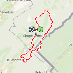
Trail Mountain bike of 31 km to be discovered at Bourgogne-Franche-Comté, Doubs, Chapelle-des-Bois. This trail is proposed by tracegps.

Description

Espace VTT FFC Val de Mouthe – Chapelle des Bois. Circuit labellisé par la Fédération Française de Cyclisme. Tour du Risoux. Très beau circuit pour une balade à la journée. La montée du Risoux se fait progressivement par le Chalet Pin - Pré Poncet et la route goudronnée du Cardot. Passage en Suisse après la Roche Champion (balisage uniquement au carrefour de la route). Après la Roche Bernard, le sentier est assez technique sur 2 km. La descente du Risoux et le retour par les lacs sont très roulants. Possibilité de rejoindre le refuge du Chalet Gaillard depuis la Roche Bernard. (Source )

Elevation profile

Positioning

Country:
France
Region :
Bourgogne-Franche-Comté
Department/Province :
Doubs
Municipality :
Chapelle-des-Bois
Location:
Unknown
Start:(UTM)
278958 ; 5164541 (32T) N.

Trails nearby

Trail Walking Chapelle-des-Bois - roche Bernard - Photo
Walking
Bogapuki

Walking

Medium
(1)
Chapelle-des-Bois, Bourgogne-Franche-Comté, Doubs, France
15 km | 21 km-effort
4h 33min
Yes
Trail Walking Chapelle-des-Bois - ROCHE CHAMPION - Photo
Walking
ehresmann

Walking

Easy
(2)
Chapelle-des-Bois, Bourgogne-Franche-Comté, Doubs, France
8.6 km | 13.6 km-effort
1h 50min
Yes
Trail Walking Bellefontaine - Lac de Bellefontaine er lac des Mortes . - Photo
Walking
nana1643

Walking

Easy
Bellefontaine, Bourgogne-Franche-Comté, Jura, France
9.5 km | 11.5 km-effort
2h 33min
Yes
Trail Walking Chapelle-des-Bois - Roche Champion et Bernard 11.7.24 - Photo
Walking
GUIDE
fredetpascale

Walking

Medium
Chapelle-des-Bois, Bourgogne-Franche-Comté, Doubs, France
11.5 km | 16.6 km-effort
3h 45min
Yes
Trail Walking Bellefontaine - Pichonnier-Peraillet- village par l'Évalude - Photo
Walking
Mady Lambert

Walking

Difficult
Bellefontaine, Bourgogne-Franche-Comté, Jura, France
5.4 km | 7.5 km-effort
1h 53min
Yes
Trail Hybrid bike Chapelle-des-Bois - Risoux - Photo
Hybrid bike
bersuz bersuz

Hybrid bike

Very easy
(1)
Chapelle-des-Bois, Bourgogne-Franche-Comté, Doubs, France
21 km | 27 km-effort
2h 0min
No
Trail Walking Bellefontaine - Des lacs de Bellefontaine vers le belvédère de la roche Bernard. - Photo
Walking
fizz1212

Walking

Difficult
Bellefontaine, Bourgogne-Franche-Comté, Jura, France
5.8 km | 8.7 km-effort
1h 53min
Yes
Trail Walking Bellefontaine - Autour de la citadelle. - Photo
Walking
fizz1212

Walking

Easy
Bellefontaine, Bourgogne-Franche-Comté, Jura, France
3.8 km | 5 km-effort
1h 4min
Yes
Trail Walking Bellefontaine - Le point de vue de la roche devant - Photo
Walking
fizz1212

Walking

Easy
(1)
Bellefontaine, Bourgogne-Franche-Comté, Jura, France
6.2 km | 8.9 km-effort
1h 51min
Yes


Close
My subscriptions