![](/images/other/stat-length.png)
![Trail Walking Mont-Roc - Rasisse Mont Roc - Photo](https://media.geolcdn.com/t/1900/400/ext.pjpeg?maxdim=2&url=https%3A%2F%2Fstatic1.geolcdn.com%2Fsiteimages%2Fupload%2Ffiles%2F1553511878bg_sport_marche.png)
Rasisse Mont Roc
jpipacific
User
![Length](/images/other/stat-length.png)
Length
8.8 km
![Max alt](https://static1.geolcdn.com/siteimages/upload/files/1508320355ic_sort_altitude_max_24dp.png)
Max alt
561 m
![Uphill gradient](https://static1.geolcdn.com/siteimages/upload/files/1508320355ic_sort_den_pos_24dp.png)
Uphill gradient
302 m
![Km-Effort](/images/other/stat-length.png)
Km-Effort
12.8 km
![Min alt](https://static1.geolcdn.com/siteimages/upload/files/1508320355ic_sort_altitude_min_24dp.png)
Min alt
325 m
![Downhill gradient](https://static1.geolcdn.com/siteimages/upload/files/1508320355ic_sort_den_neg_24dp.png)
Downhill gradient
302 m
![Boucle](https://static1.geolcdn.com/siteimages/upload/files/16400158638029165_repeat_loop_refresh_sync_direction_icon.png)
Boucle
Yes
Creation date :
2019-01-15 15:00:51.894
Updated on :
2019-01-15 15:00:51.894
![Walking](https://static1.geolcdn.com/sitytour/trail-icons/101.png)
2h32
Difficulty : Medium
![Scan this QR Code to open this trail in the SityTrail application](https://capi.geolives.com/qq0zvz2zws4bq2lad0pu/sitytour/trails/1026239/qr.png?size=200)
FREE GPS app for hiking
About
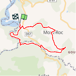
Trail Walking of 8.8 km to be discovered at Occitania, Tarn, Mont-Roc. This trail is proposed by jpipacific.
Description
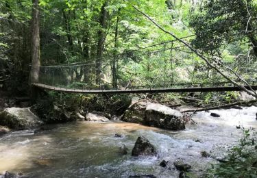
chemin en forêt à l'ombre qui suit la rivière puis monte par la route avant de retourner au départ par un chemin. Parfois la trace n'est pas facile à trouver car la carte ne correspond pas bien. Au départ je n'ai pas trouver le GR 36
Positioning
Country:
France
Region :
Occitania
Department/Province :
Tarn
Municipality :
Mont-Roc
Location:
Unknown
Start:(Dec)
Start:(UTM)
447820 ; 4850531 (31T) N.
Comments
Trails nearby
![Trail Walking Arifat - cascades d'Arifat - Photo](https://media.geolcdn.com/t/375/260/c78a1e41-2a93-4ead-9d6b-9d9e14c876a7.jpg&format=jpg&maxdim=2)
![Walking Walking](https://static1.geolcdn.com/sitytour/trail-icons/101.png)
cascades d'Arifat
Walking
Difficult
Arifat,
Occitania,
Tarn,
France
![](/images/other/stat-length.png)
6 km | 9.1 km-effort
1h 58min
![](https://static1.geolcdn.com/siteimages/upload/files/16400158638029165_repeat_loop_refresh_sync_direction_icon.png)
Yes
![Trail Electric bike Terre-de-Bancalié - Boucle de Roque à Roque - Photo](https://media.geolcdn.com/t/375/260/ext.jpg?maxdim=2&url=https%3A%2F%2Fstatic1.geolcdn.com%2Fsiteimages%2Fupload%2Ffiles%2F1524743154velo.jpg)
![Electric bike Electric bike](https://static1.geolcdn.com/sitytour/trail-icons/205.png)
Boucle de Roque à Roque
Electric bike
Difficult
(1)
Terre-de-Bancalié,
Occitania,
Tarn,
France
![](/images/other/stat-length.png)
29 km | 41 km-effort
Unknown
![](https://static1.geolcdn.com/siteimages/upload/files/16400158638029165_repeat_loop_refresh_sync_direction_icon.png)
Yes
![Trail Walking Terre-de-Bancalié - le travet- traversee du Dadou - Photo](https://media.geolcdn.com/t/375/260/ext.jpg?maxdim=2&url=https%3A%2F%2Fstatic1.geolcdn.com%2Fsiteimages%2Fupload%2Ffiles%2F1553511878bg_sport_marche.png)
![Walking Walking](https://static1.geolcdn.com/sitytour/trail-icons/101.png)
le travet- traversee du Dadou
Walking
Very difficult
(1)
Terre-de-Bancalié,
Occitania,
Tarn,
France
![](/images/other/stat-length.png)
24 km | 36 km-effort
8h 9min
![](https://static1.geolcdn.com/siteimages/upload/files/16400158638029165_repeat_loop_refresh_sync_direction_icon.png)
Yes
![Trail Walking Arifat - 81_Arifat_longue_projet - Photo](https://media.geolcdn.com/t/375/260/ext.jpg?maxdim=2&url=https%3A%2F%2Fstatic1.geolcdn.com%2Fsiteimages%2Fupload%2Ffiles%2F1553511878bg_sport_marche.png)
![Walking Walking](https://static1.geolcdn.com/sitytour/trail-icons/101.png)
81_Arifat_longue_projet
Walking
Medium
Arifat,
Occitania,
Tarn,
France
![](/images/other/stat-length.png)
16.1 km | 24 km-effort
4h 20min
![](https://static1.geolcdn.com/siteimages/upload/files/16400158638029165_repeat_loop_refresh_sync_direction_icon.png)
Yes
![Trail Walking Arifat - 81_Arifat_Dadounet - Photo](https://media.geolcdn.com/t/375/260/ext.jpg?maxdim=2&url=https%3A%2F%2Fstatic1.geolcdn.com%2Fsiteimages%2Fupload%2Ffiles%2F1553511878bg_sport_marche.png)
![Walking Walking](https://static1.geolcdn.com/sitytour/trail-icons/101.png)
81_Arifat_Dadounet
Walking
Difficult
(1)
Arifat,
Occitania,
Tarn,
France
![](/images/other/stat-length.png)
15.2 km | 23 km-effort
4h 57min
![](https://static1.geolcdn.com/siteimages/upload/files/16400158638029165_repeat_loop_refresh_sync_direction_icon.png)
Yes
![Trail Walking Arifat - 81_Saint Paul d'Arifat - Photo](https://media.geolcdn.com/t/375/260/ext.jpg?maxdim=2&url=https%3A%2F%2Fstatic1.geolcdn.com%2Fsiteimages%2Fupload%2Ffiles%2F1553511878bg_sport_marche.png)
![Walking Walking](https://static1.geolcdn.com/sitytour/trail-icons/101.png)
81_Saint Paul d'Arifat
Walking
Medium
Arifat,
Occitania,
Tarn,
France
![](/images/other/stat-length.png)
19.1 km | 27 km-effort
5h 55min
![](https://static1.geolcdn.com/siteimages/upload/files/16400158638029165_repeat_loop_refresh_sync_direction_icon.png)
Yes
![Trail Walking Arifat - Cascades de Arifat - Photo](https://media.geolcdn.com/t/375/260/ext.jpg?maxdim=2&url=https%3A%2F%2Fstatic1.geolcdn.com%2Fsiteimages%2Fupload%2Ffiles%2F1553511878bg_sport_marche.png)
![Walking Walking](https://static1.geolcdn.com/sitytour/trail-icons/101.png)
Cascades de Arifat
Walking
Medium
Arifat,
Occitania,
Tarn,
France
![](/images/other/stat-length.png)
8.7 km | 13.1 km-effort
2h 39min
![](https://static1.geolcdn.com/siteimages/upload/files/16400158638029165_repeat_loop_refresh_sync_direction_icon.png)
Yes
![Trail Walking Terre-de-Bancalié - le travet - Photo](https://media.geolcdn.com/t/375/260/ext.jpg?maxdim=2&url=https%3A%2F%2Fstatic1.geolcdn.com%2Fsiteimages%2Fupload%2Ffiles%2F1553511878bg_sport_marche.png)
![Walking Walking](https://static1.geolcdn.com/sitytour/trail-icons/101.png)
![Trail Walking Arifat - 81_Arifat_long_reco - Photo](https://media.geolcdn.com/t/375/260/ext.jpg?maxdim=2&url=https%3A%2F%2Fstatic1.geolcdn.com%2Fsiteimages%2Fupload%2Ffiles%2F1553511878bg_sport_marche.png)
![Walking Walking](https://static1.geolcdn.com/sitytour/trail-icons/101.png)
81_Arifat_long_reco
Walking
Difficult
Arifat,
Occitania,
Tarn,
France
![](/images/other/stat-length.png)
16.2 km | 24 km-effort
21min
![](https://static1.geolcdn.com/siteimages/upload/files/16400158638029165_repeat_loop_refresh_sync_direction_icon.png)
Yes