Trail Running Eccica-Suarella - La Suarellaise - Course pédestre à Eccica Suarella - Photo

La Suarellaise - Course pédestre à Eccica Suarella

 tracegps
tracegps

User

© OpenStreetMap contributors
Length
Length
14.6 km
Max alt
Max alt
235 m
Uphill gradient
Uphill gradient
351 m
Km-Effort
Km-Effort  
19.3 km
Min alt
Min alt
38 m
Downhill gradient
Downhill gradient
351 m
Boucle
Boucle
Yes
Creation date :
2014-12-10 00:00:00.0
Updated on :
2014-12-10 00:00:00.0

(0 Reviews)

Running
Running
1h15
Difficulty : Difficult

Scan this QR Code to open this trail in the SityTrail application

FREE GPS app for hiking

Logo SityTrail SityTrail

IGN / Geographical institutes

Download SityTrail from the App Store Download SityTrail from Google Play

Logo SityTrail SityTrail World

The world is yours!

Download SityTrail from the App Store Download SityTrail from Google Play Download SityTrail on Huawei AppGallery

About

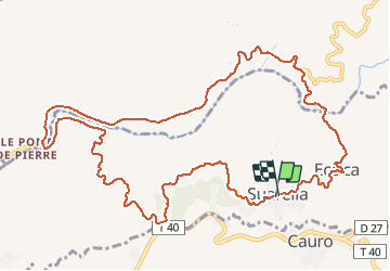
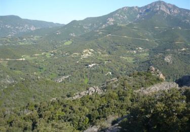
Trail Running of 14.6 km to be discovered at Corsica, South Corsica, Eccica-Suarella. This trail is proposed by tracegps.

Description

Course pédestre à Eccica Suarella, La Suarellaise 2008. Rendez-vous Dimanche 10 Août 2008 pour la 8ème édition ! Le départ de la course des AS sera donné à partir de 17h30 devant la place de la mairie. Après une descente d'1 km le parcours traversera le hameau d'Eccica puis empruntera un sentier étroit où fut assassiné Sampiero Corso le 17/01/1567. Une stèle à été érigée en 1891 à l'endroit où lieu le guet-apens. Ce petit tronçon rejoint le pont de la Vanna. Après 1 km de montée, premier ravitaillement à l'embranchement d'Ocana, un faux plat descendant de 5 km rejoint le pont de la Pierre où un deuxième ravitaillement s'impose. Suit une montée de 3 km 800 jusqu'à l'embranchement du Stangone avec le troisième ravitaillement, puis les 3 derniers km seront très vallonnés avec des portions en terre et l'arrivée sera jugée place de la mairie ou un public très nombreux vous attendra....

Elevation profile

Photos

Positioning

Country:
France
Region :
Corsica
Department/Province :
South Corsica
Municipality :
Eccica-Suarella
Location:
Unknown
Start:(UTM)
492275 ; 4641192 (32T) N.

Trails nearby

Trail Walking Cauro - Arche de CAURO - Photo
Walking
cathymac20

Walking

Easy
(3)
Cauro, Corsica, South Corsica, France
3.9 km | 6.2 km-effort
2h 47min
Yes
Trail Mountain bike Cauro - vtt cauro accelasca piste ruppione et retour - Photo
Mountain bike
Orsu Vincenti

Mountain bike

Medium
Cauro, Corsica, South Corsica, France
47 km | 56 km-effort
2h 57min
No
Trail Walking Eccica-Suarella - Cauro, de Pian di veccia jusqu'au Prunu - Photo
Walking
daisychain

Walking

Medium
Eccica-Suarella, Corsica, South Corsica, France
5 km | 9.2 km-effort
2h 6min
No
Trail Walking Grosseto-Prugna - Ma Mare a Mare centre étape 2: du col St Georges vers Quasquara - Photo
Walking
Vadim

Walking

Difficult
Grosseto-Prugna, Corsica, South Corsica, France
14.6 km | 25 km-effort
5h 1min
No
Trail Running Eccica-Suarella - Trail de Sampiero - Photo
Running
tracegps

Running

Medium
(1)
Eccica-Suarella, Corsica, South Corsica, France
12.2 km | 21 km-effort
2h 0min
Yes
Trail Walking Eccica-Suarella - Trail de Sampiero - Photo
Walking
tracegps

Walking

Medium
(1)
Eccica-Suarella, Corsica, South Corsica, France
12.2 km | 21 km-effort
3h 30min
Yes
Trail Walking Cauro - cauro col st Antoine  - Photo
Walking
supernini2a

Walking

Very easy
(1)
Cauro, Corsica, South Corsica, France
11 km | 16.2 km-effort
3h 37min
Yes
Trail Walking Grosseto-Prugna - Mar A Mar sixième jour - Photo
Walking
ezola

Walking

Very difficult
(1)
Grosseto-Prugna, Corsica, South Corsica, France
18.5 km | 25 km-effort
5h 0min
No
Trail On foot Cuttoli-Corticchiato - Monte Aragnascu - Photo
On foot
GUIDE+

On foot

Easy
Cuttoli-Corticchiato, Corsica, South Corsica, France
8.1 km | 13.1 km-effort
2h 58min
No


Close
My subscriptions