En forêt de Pincé
tracegps
User
Length
22 km
Max alt
68 m
Uphill gradient
193 m
Km-Effort
25 km
Min alt
26 m
Downhill gradient
193 m
Boucle
Yes
Creation date :
2014-12-10 00:00:00.0
Updated on :
2014-12-10 00:00:00.0
5h00
Difficulty : Medium
FREE GPS app for hiking
About
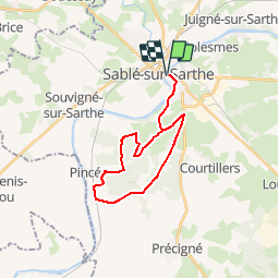
Trail Walking of 22 km to be discovered at Pays de la Loire, Sarthe, Sablé-sur-Sarthe. This trail is proposed by tracegps.
Description
La forêt de Pincé avec ses chemins de randonnée (Un topoguide est disponible à l’Office de Tourisme du Pays de Sablé)
Positioning
Country:
France
Region :
Pays de la Loire
Department/Province :
Sarthe
Municipality :
Sablé-sur-Sarthe
Location:
Unknown
Start:(Dec)
Start:(UTM)
699843 ; 5301849 (30T) N.
Comments
Trails nearby
BRT J4 96KM D+900 - 61MATIN KM D+650 / APRES MIDI 35KM D+ 250
Mountain bike
Easy
Sablé-sur-Sarthe,
Pays de la Loire,
Sarthe,
France
96 km | 108 km-effort
12min
No
R,e,T J4
Mountain bike
Very easy
Sablé-sur-Sarthe,
Pays de la Loire,
Sarthe,
France
110 km | 123 km-effort
8h 17min
No
La Sarthe-09-Sablé - Brissarthe
Walking
Easy
Sablé-sur-Sarthe,
Pays de la Loire,
Sarthe,
France
25 km | 27 km-effort
5h 51min
No
juigné sur sarthe
Walking
Easy
Juigné-sur-Sarthe,
Pays de la Loire,
Sarthe,
France
14.7 km | 16.2 km-effort
Unknown
Yes
2021-10-24 rando jean
Walking
Easy
Sablé-sur-Sarthe,
Pays de la Loire,
Sarthe,
France
4 km | 4.6 km-effort
51min
Yes
Abbaye de Solesmes
Nordic walking
Very easy
Juigné-sur-Sarthe,
Pays de la Loire,
Sarthe,
France
3 km | 3.6 km-effort
Unknown
Yes
Tour des Places à Juigné
Walking
Easy
Juigné-sur-Sarthe,
Pays de la Loire,
Sarthe,
France
5.2 km | 5.6 km-effort
1h 23min
No
Juigné à Asnières
Walking
Easy
Juigné-sur-Sarthe,
Pays de la Loire,
Sarthe,
France
11.8 km | 13.2 km-effort
3h 38min
No
Sablé sur Sarthe - Chateaubriand 4ieme jour
Mountain bike
Medium
Sablé-sur-Sarthe,
Pays de la Loire,
Sarthe,
France
99 km | 112 km-effort
6h 14min
No
belle promenade en forêt sans aucune difficulté