Trail Mountain bike Saint-Jean-Saint-Nicolas - Espace VTT FFC du Champsaur - Circuit n°9 - De la Ripisylve au canal - Photo

Espace VTT FFC du Champsaur - Circuit n°9 - De la Ripisylve au canal

 tracegps
tracegps

User

© OpenStreetMap contributors
Length
Length
12.9 km
Max alt
Max alt
1206 m
Uphill gradient
Uphill gradient
169 m
Km-Effort
Km-Effort  
15.1 km
Min alt
Min alt
1061 m
Downhill gradient
Downhill gradient
169 m
Boucle
Boucle
Yes
Creation date :
2014-12-10 00:00:00.0
Updated on :
2014-12-10 00:00:00.0

(1 Reviews)

Mountain bike
Mountain bike
1h15
Difficulty : Medium

Scan this QR Code to open this trail in the SityTrail application

FREE GPS app for hiking

Logo SityTrail SityTrail

IGN / Geographical institutes

Download SityTrail from the App Store Download SityTrail from Google Play

Logo SityTrail SityTrail World

The world is yours!

Download SityTrail from the App Store Download SityTrail from Google Play Download SityTrail on Huawei AppGallery

About

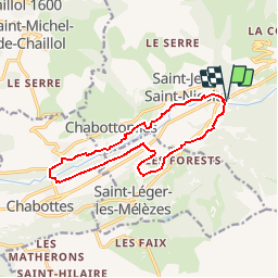
Trail Mountain bike of 12.9 km to be discovered at Provence-Alpes-Côte d'Azur, Hautes-Alpes, Saint-Jean-Saint-Nicolas. This trail is proposed by tracegps.

Description

Espace VTT FFC du Champsaur Circuit labellisé par la Fédération Française de Cyclisme. Aux portes du Parc national des Ecrins, le Champsaur est une vallée propice à un large éventail de circuits de tous niveaux. La grande diversité des milieux naturels offre des paysages où la douceur du bocage côtoie la haute montagne.

Elevation profile

Photos

Positioning

Country:
France
Region :
Provence-Alpes-Côte d'Azur
Department/Province :
Hautes-Alpes
Municipality :
Saint-Jean-Saint-Nicolas
Location:
Unknown
Start:(UTM)
280375 ; 4949670 (32T) N.

Comments

Please log in to post a review or rate the element


Trails nearby

Trail Walking Saint-Jean-Saint-Nicolas - Circuit de Costebelle - Photo
Walking
Dervalmarc

Walking

Very easy
(2)
Saint-Jean-Saint-Nicolas, Provence-Alpes-Côte d'Azur, Hautes-Alpes, France
7.4 km | 12.1 km-effort
2h 16min
Yes
Trail Running Ancelle - Ancelle-Tour du Cuchon - Photo
Running
frederique.marti@laposte.net

Running

Very easy
(2)
Ancelle, Provence-Alpes-Côte d'Azur, Hautes-Alpes, France
15.4 km | 26 km-effort
3h 15min
Yes
Trail Walking Ancelle - col de la coupa et tour de la rouanne - Photo
Walking
chdubois

Walking

Difficult
(1)
Ancelle, Provence-Alpes-Côte d'Azur, Hautes-Alpes, France
16.2 km | 28 km-effort
4h 56min
Yes
Trail Walking Ancelle - Le Piolt par la Pourrachiere 21/07/23 - Photo
Walking
GUIDE
R@ph

Walking

Very difficult
Ancelle, Provence-Alpes-Côte d'Azur, Hautes-Alpes, France
13.7 km | 25 km-effort
5h 41min
Yes
Trail Walking Saint-Jean-Saint-Nicolas - Le Palastre - Photo
Walking
GUIDE
Marco05

Walking

Medium
Saint-Jean-Saint-Nicolas, Provence-Alpes-Côte d'Azur, Hautes-Alpes, France
9.1 km | 17.9 km-effort
4h 4min
Yes
Trail Walking Saint-Michel-de-Chaillol - Col de l'Escalier - Photo
Walking
GUIDE
Marco05

Walking

Difficult
Saint-Michel-de-Chaillol, Provence-Alpes-Côte d'Azur, Hautes-Alpes, France
16 km | 27 km-effort
6h 13min
Yes
Trail Walking Ancelle - suuntoapp-Hiking-2022-08-29T07-01-11Z - Photo
Walking
GUIDE
Marco05

Walking

Difficult
Ancelle, Provence-Alpes-Côte d'Azur, Hautes-Alpes, France
13.3 km | 25 km-effort
5h 0min
Yes
Trail Walking Saint-Michel-de-Chaillol - Pic Queyrel - Photo
Walking
GUIDE
Marco05

Walking

Difficult
Saint-Michel-de-Chaillol, Provence-Alpes-Côte d'Azur, Hautes-Alpes, France
10.4 km | 19.8 km-effort
4h 29min
Yes
Trail Walking Saint-Michel-de-Chaillol - Pic du Tourond - Photo
Walking
GUIDE
Marco05

Walking

Very difficult
Saint-Michel-de-Chaillol, Provence-Alpes-Côte d'Azur, Hautes-Alpes, France
13.7 km | 27 km-effort
6h 14min
Yes


Close
My subscriptions