Trail Walking Salles - Soum de Conques - Photo
 tracegps
tracegps

User

© OpenStreetMap contributors
Length
Length
9.7 km
Max alt
Max alt
1735 m
Uphill gradient
Uphill gradient
700 m
Km-Effort
Km-Effort  
19.1 km
Min alt
Min alt
1073 m
Downhill gradient
Downhill gradient
702 m
Boucle
Boucle
Yes
Creation date :
2014-12-10 00:00:00.0
Updated on :
2014-12-10 00:00:00.0

(0 Reviews)

Walking
Walking
4h00
Difficulty : Difficult

Scan this QR Code to open this trail in the SityTrail application

FREE GPS app for hiking

Logo SityTrail SityTrail

IGN / Geographical institutes

Download SityTrail from the App Store Download SityTrail from Google Play

Logo SityTrail SityTrail World

The world is yours!

Download SityTrail from the App Store Download SityTrail from Google Play Download SityTrail on Huawei AppGallery

About

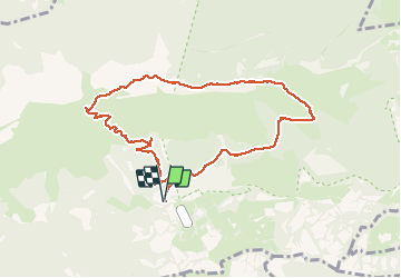
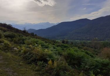
Trail Walking of 9.7 km to be discovered at Occitania, Hautespyrenees, Salles. This trail is proposed by tracegps.

Description

Cette rando a déjà été décrite en partie sur le site Randonnée Passion Massif du Pibeste (voir les liens de FredRando, par exemple Cabaliros, pointe de Surgatte ...) Je vous propose de la faire en boucle, en redescendant par le col de Las Escures. Il y a aussi un petit raccourci qui évite le col d'Andorre, c'est une jolie crête. Elle est agréable en hiver, les chasses se déroulant soit plus bas dans la vallée, soit plus haut. Vous avez 9 chances sur 10 de voir des mouflons, des isards ou des chevreuils. C'est à l'automne qu'elle est la plus belle. En été, il y a du bétail (Je le dis si comme moi vous avez un chien). Il n'y a pas d'eau, prenez en. Dans la descente depuis le col les chemins ne sont pas toujours bien nets. Essayez de trouver les ruines pour vous repèrer. Je vous prie d'excuser mon manque de précision, c'est la première rando que je propose, je vous promets de m'appliquer ...

Elevation profile

Photos

Positioning

Country:
France
Region :
Occitania
Department/Province :
Hautespyrenees
Municipality :
Salles
Location:
Unknown
Start:(UTM)
729699 ; 4767037 (30T) N.

Trails nearby

Trail Walking Arcizans-Dessus - la fontaine de Nabias - Photo
Walking
bernardbelmas

Walking

Very easy
(1)
Arcizans-Dessus, Occitania, Hautespyrenees, France
4.2 km | 6.8 km-effort
1h 40min
Yes
Trail Snowshoes Aucun - Le Soum de Berducou - Photo
Snowshoes
tracegps

Snowshoes

Medium
(1)
Aucun, Occitania, Hautespyrenees, France
5.3 km | 9.6 km-effort
3h 15min
Yes
Trail Walking Gaillagos - GAILLAGOS / Couret / Couraduque en boucle reco G3 - Photo
Walking
GUIDE
marmotte65

Walking

Difficult
Gaillagos, Occitania, Hautespyrenees, France
8.4 km | 14.3 km-effort
2h 30min
Yes
Trail Walking Salles - SALLES Le col d'Andorre avec nos voisins pierrefittois - Photo
Walking
GUIDE
marmotte65

Walking

Difficult
Salles, Occitania, Hautespyrenees, France
7.5 km | 13.2 km-effort
2h 52min
Yes
Trail On foot Salles - SALLES-ARGELES col d'Andorre et soum de Leiz (ou pas)  2796042 - Photo
On foot
GUIDE
marmotte65

On foot

Easy
Salles, Occitania, Hautespyrenees, France
8.2 km | 14 km-effort
3h 10min
Yes
Trail Walking Salles - Escala du Prat du Rey - Photo
Walking
DuMarsan

Walking

Medium
(1)
Salles, Occitania, Hautespyrenees, France
11.3 km | 22 km-effort
4h 24min
Yes
Trail Winter sports Aucun - couraduc soulor - Photo
Winter sports
ehresmann

Winter sports

Difficult
(1)
Aucun, Occitania, Hautespyrenees, France
34 km | 45 km-effort
2h 31min
Yes
Trail Winter sports Aucun - Bazes soulor - Photo
Winter sports
ehresmann

Winter sports

Medium
(1)
Aucun, Occitania, Hautespyrenees, France
25 km | 34 km-effort
2h 4min
Yes
Trail Walking Gaillagos - GAILLAGOS Col de Couret Couraduque en boucle G3 du 21/04/2023
Walking
GUIDE
marmotte65

Walking

Difficult
Gaillagos, Occitania, Hautespyrenees, France
8.2 km | 14.2 km-effort
2h 46min
Yes


Close
My subscriptions