![](/images/other/stat-length.png)
![Trail Mountain bike Remollon - Espace VTT FFC de Serre-Ponçon - Durance - Circuit n°17 - Rousset - Photo](https://media.geolcdn.com/t/1900/400/ext.pjpeg?maxdim=2&url=https%3A%2F%2Fservices.sitytrail.com%2FGeolivesWS%2FDownloadMedia.ashx%3FTrailID%3D102060%26Media%3D2382_1.jpg)
Espace VTT FFC de Serre-Ponçon - Durance - Circuit n°17 - Rousset
tracegps
User
![Length](/images/other/stat-length.png)
![Max alt](https://static1.geolcdn.com/siteimages/upload/files/1508320355ic_sort_altitude_max_24dp.png)
![Uphill gradient](https://static1.geolcdn.com/siteimages/upload/files/1508320355ic_sort_den_pos_24dp.png)
![Km-Effort](/images/other/stat-length.png)
![Min alt](https://static1.geolcdn.com/siteimages/upload/files/1508320355ic_sort_altitude_min_24dp.png)
![Downhill gradient](https://static1.geolcdn.com/siteimages/upload/files/1508320355ic_sort_den_neg_24dp.png)
![Boucle](https://static1.geolcdn.com/siteimages/upload/files/16400158638029165_repeat_loop_refresh_sync_direction_icon.png)
![Mountain bike](https://static1.geolcdn.com/sitytour/trail-icons/202.png)
40m
Difficulty : Medium
![Scan this QR Code to open this trail in the SityTrail application](https://capi.geolives.com/qq0zvz2zws4bq2lad0pu/sitytour/trails/102060/qr.png?size=200)
FREE GPS app for hiking
About
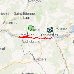
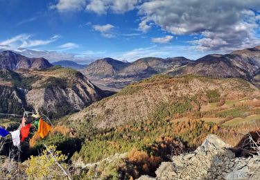
Trail Mountain bike of 9.6 km to be discovered at Provence-Alpes-Côte d'Azur, Hautes-Alpes, Remollon. This trail is proposed by tracegps.
Description
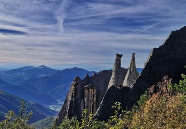
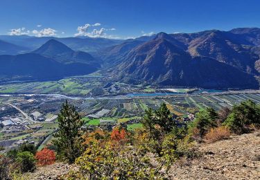
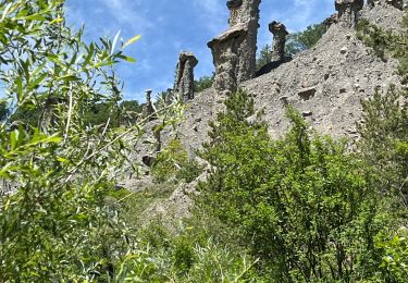
Espace VTT FFC de Serre-Ponçon - Durance Circuit labellisé par la Fédération Française de Cyclisme. Départ depuis le lavoir de Remollon au centre du village. Circuit familial presque à plat reliant Remollon à Rousset-Espinasses. Attention au départ en descente dans les ruelles étroites. Retour par le même chemin (circuit 16) Découverte de la vallée de la Durance à travers cultures, jardins et vergers. Remollon et ses vieilles ruelles. La chapelle Saint Roch sur sa butte. Les Celliers de Rousset et ses cités Edf datant de la construction du barrage.
Positioning
Comments
Trails nearby
![Trail Walking Théus - R47 Les Demoiselles Coiffees - Photo](https://media.geolcdn.com/t/375/260/ext.jpg?maxdim=2&url=https%3A%2F%2Fservices.sitytrail.com%2FGeolivesWS%2FDownloadMedia.ashx%3FTrailID%3D890906%26Media%3Dc8a3e36a-3aa2-4d75-b341-12feab72a468.jpg)
![Walking Walking](https://static1.geolcdn.com/sitytour/trail-icons/101.png)
Walking
![](/images/other/stat-length.png)
![](https://static1.geolcdn.com/siteimages/upload/files/16400158638029165_repeat_loop_refresh_sync_direction_icon.png)
![Trail Walking Théus - Les demoiselles coiffées - Photo](https://media.geolcdn.com/t/375/260/1a3b1ded-039c-4f3a-9433-82de273504ad.jpeg&format=jpg&maxdim=2)
![Walking Walking](https://static1.geolcdn.com/sitytour/trail-icons/101.png)
Walking
![](/images/other/stat-length.png)
![](https://static1.geolcdn.com/siteimages/upload/files/16400158638029165_repeat_loop_refresh_sync_direction_icon.png)
![Trail Walking Rochebrune - Chapelle Saint-Sixte Via Rochebrune - Photo](https://media.geolcdn.com/t/375/260/0f20d05e-b7e6-44b4-b471-8732af4f1fc9.jpg&format=jpg&maxdim=2)
![Walking Walking](https://static1.geolcdn.com/sitytour/trail-icons/101.png)
Walking
![](/images/other/stat-length.png)
![](https://static1.geolcdn.com/siteimages/upload/files/16400158638029165_repeat_loop_refresh_sync_direction_icon.png)
![Trail Walking Jarjayes - VALSAIRES CHAPELLE NOTRE DAME DU LAIS - Photo](https://media.geolcdn.com/t/375/260/860e51d5-4111-42e4-9649-8920f6056baf.jpg&format=jpg&maxdim=2)
![Walking Walking](https://static1.geolcdn.com/sitytour/trail-icons/101.png)
Walking
![](/images/other/stat-length.png)
![](https://static1.geolcdn.com/siteimages/upload/files/16400158638029165_repeat_loop_refresh_sync_direction_icon.png)
![Trail Walking Remollon - Remollon-un-tresor-cache-de-la-vallee-de-la-durance - Photo](https://media.geolcdn.com/t/375/260/073a624b-9a54-4ca5-a179-7003c0d6383d.jpg&format=jpg&maxdim=2)
![Walking Walking](https://static1.geolcdn.com/sitytour/trail-icons/101.png)
Walking
![](/images/other/stat-length.png)
![](https://static1.geolcdn.com/siteimages/upload/files/16400158638029165_repeat_loop_refresh_sync_direction_icon.png)
![Trail Walking Espinasses - Salle-de-bal-des-demoiselles-coiffees-via-serre-giraud - Photo](https://media.geolcdn.com/t/375/260/308e4b93-b724-42e4-abd4-cc3772156253.jpg&format=jpg&maxdim=2)
![Walking Walking](https://static1.geolcdn.com/sitytour/trail-icons/101.png)
Walking
![](/images/other/stat-length.png)
![](https://static1.geolcdn.com/siteimages/upload/files/16400158638029165_repeat_loop_refresh_sync_direction_icon.png)
![Trail Walking Espinasses - les-demoiselles-coiffees-d-espinasses-theus-et-remollon - Photo](https://media.geolcdn.com/t/375/260/1af52faf-437c-42bd-b3af-b635ea9a33d1.jpg&format=jpg&maxdim=2)
![Walking Walking](https://static1.geolcdn.com/sitytour/trail-icons/101.png)
Walking
![](/images/other/stat-length.png)
![](https://static1.geolcdn.com/siteimages/upload/files/16400158638029165_repeat_loop_refresh_sync_direction_icon.png)
![Trail Walking Remollon - Des Demoiselles Coiffées aux balcons de Remollon - Photo](https://media.geolcdn.com/t/375/260/2094a0e8-535c-4f81-bf59-f1f898a15092.jpg&format=jpg&maxdim=2)
![Walking Walking](https://static1.geolcdn.com/sitytour/trail-icons/101.png)
Walking
![](/images/other/stat-length.png)
![](https://static1.geolcdn.com/siteimages/upload/files/16400158638029165_repeat_loop_refresh_sync_direction_icon.png)
![Trail sport Théus - Mont colombes - Photo](https://media.geolcdn.com/t/375/260/7f8bb3c6-ed1f-4673-837c-336a1770738b.jpg&format=jpg&maxdim=2)
sport
![](/images/other/stat-length.png)
![](https://static1.geolcdn.com/siteimages/upload/files/16400158638029165_repeat_loop_refresh_sync_direction_icon.png)