![](/images/other/stat-length.png)
![Trail Running Massac-Séran - Voie Romaine Massac Séran - Photo](https://media.geolcdn.com/t/1900/400/ext.pjpeg?maxdim=2&url=https%3A%2F%2Fstatic1.geolcdn.com%2Fsiteimages%2Fupload%2Ffiles%2F1524743154running.jpg)
Voie Romaine Massac Séran
tracegps
User
![Length](/images/other/stat-length.png)
![Max alt](https://static1.geolcdn.com/siteimages/upload/files/1508320355ic_sort_altitude_max_24dp.png)
![Uphill gradient](https://static1.geolcdn.com/siteimages/upload/files/1508320355ic_sort_den_pos_24dp.png)
![Km-Effort](/images/other/stat-length.png)
![Min alt](https://static1.geolcdn.com/siteimages/upload/files/1508320355ic_sort_altitude_min_24dp.png)
![Downhill gradient](https://static1.geolcdn.com/siteimages/upload/files/1508320355ic_sort_den_neg_24dp.png)
![Boucle](https://static1.geolcdn.com/siteimages/upload/files/16400158638029165_repeat_loop_refresh_sync_direction_icon.png)
![Running](https://static1.geolcdn.com/sitytour/trail-icons/103.png)
1h00
Difficulty : Medium
![Scan this QR Code to open this trail in the SityTrail application](https://capi.geolives.com/qq0zvz2zws4bq2lad0pu/sitytour/trails/101980/qr.png?size=200)
FREE GPS app for hiking
About
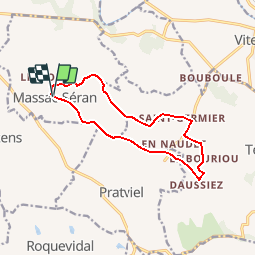
Trail Running of 12.4 km to be discovered at Occitania, Tarn, Massac-Séran. This trail is proposed by tracegps.
Description
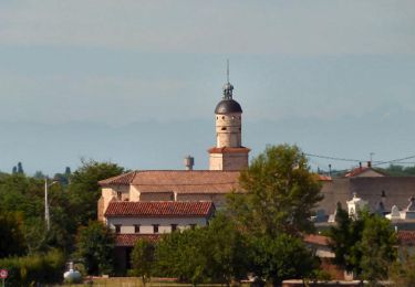
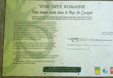
Départ de la mairie en face de l’église. Continuez le chemin, il est très bien indiqué Voie Romaine et continue en chemin de terre. Vous arrivez à une route goudronnée, traversez et continuer le chemin de terre en face « Voie Romaine ». Vous arrivez à une seconde route goudronnée, traversez et continuer le chemin de terre en face « Voie Romaine ». Vous passez sur un pont romain avant de rencontrer un troisième chemin goudronné ou il faut prendre à gauche. Au premier carrefour sur la gauche direction St Germier. Dans un virage en angle droit sur la droite prendre en face le chemin de terre direction Janoye. 100 m avant la ferme, prendre à gauche un autre chemin de terre il vous conduit jusqu'à la D43 « fin des chemins de terre ». Prendre à droite puis la première à gauche pour monter à St Gémier. Passer devant l’église sur votre droite Point d’eau à l’entrée du cimetière et superbe point de vue. Suivre la route, laisser un premier chemin sur votre droite puis 20 m après un autre sur votre gauche. Plus loin laisser un autre chemin sur la gauche. Arrivée en vue d’un réservoir d’eau prendre sur la gauche le chemin des Izards « et oui ! ». Sur le coteau en face vous voyez le clocher de Massac Séran. En bas au carrefour prendre à droite et remonter. Au carrefour à gauche et arrivée au point de départ.
Positioning
Comments
Trails nearby
![Trail Walking Lavaur - Les collines du vaurais - lavaur - Photo](https://media.geolcdn.com/t/375/260/ext.jpg?maxdim=2&url=https%3A%2F%2Fservices.sitytrail.com%2FGeolivesWS%2FDownloadMedia.ashx%3FTrailID%3D173240%26Media%3D14849_5.jpg)
![Walking Walking](https://static1.geolcdn.com/sitytour/trail-icons/101.png)
Walking
![](/images/other/stat-length.png)
![](https://static1.geolcdn.com/siteimages/upload/files/16400158638029165_repeat_loop_refresh_sync_direction_icon.png)
![Trail Walking Massac-Séran - La voie romaine de Massac-Séran à Puylaurens - Photo](https://media.geolcdn.com/t/375/260/ext.jpg?maxdim=2&url=https%3A%2F%2Fservices.sitytrail.com%2FGeolivesWS%2FDownloadMedia.ashx%3FTrailID%3D172629%26Media%3D13998_3.jpg)
![Walking Walking](https://static1.geolcdn.com/sitytour/trail-icons/101.png)
Walking
![](/images/other/stat-length.png)
![](https://static1.geolcdn.com/siteimages/upload/files/16400158638029165_repeat_loop_refresh_sync_direction_icon.png)
![Trail Running Lavaur - Autour de Lavaur - Massac Séran - Château de Preignan - Photo](https://media.geolcdn.com/t/375/260/ext.jpg?maxdim=2&url=https%3A%2F%2Fservices.sitytrail.com%2FGeolivesWS%2FDownloadMedia.ashx%3FTrailID%3D105820%26Media%3D9757_6.jpg)
![Running Running](https://static1.geolcdn.com/sitytour/trail-icons/103.png)
Running
![](/images/other/stat-length.png)
![](https://static1.geolcdn.com/siteimages/upload/files/16400158638029165_repeat_loop_refresh_sync_direction_icon.png)
![Trail Mountain bike Lavaur - Autour de Lavaur - Massac Séran - Château de Preignan - Photo](https://media.geolcdn.com/t/375/260/ext.jpg?maxdim=2&url=https%3A%2F%2Fservices.sitytrail.com%2FGeolivesWS%2FDownloadMedia.ashx%3FTrailID%3D105819%26Media%3D9757_6.jpg)
![Mountain bike Mountain bike](https://static1.geolcdn.com/sitytour/trail-icons/202.png)
Mountain bike
![](/images/other/stat-length.png)
![](https://static1.geolcdn.com/siteimages/upload/files/16400158638029165_repeat_loop_refresh_sync_direction_icon.png)
![Trail Walking Teyssode - naudet - Photo](https://media.geolcdn.com/t/375/260/abfdbee7-f225-436f-95c1-5fe03a47accf.jpg&format=jpg&maxdim=2)
![Walking Walking](https://static1.geolcdn.com/sitytour/trail-icons/101.png)
![Trail Mountain bike Lacougotte-Cadoul - Pays de Cocagne : Grande Boucle - Photo](https://media.geolcdn.com/t/375/260/ext.jpg?maxdim=2&url=https%3A%2F%2Fservices.sitytrail.com%2FGeolivesWS%2FDownloadMedia.ashx%3FTrailID%3D834719%26Media%3De6157327-e779-4d95-bf8a-1362439653fd.JPG)
![Mountain bike Mountain bike](https://static1.geolcdn.com/sitytour/trail-icons/202.png)
Mountain bike
![](/images/other/stat-length.png)
![](https://static1.geolcdn.com/siteimages/upload/files/16400158638029165_repeat_loop_refresh_sync_direction_icon.png)
![Trail Mountain bike Lacougotte-Cadoul - Lacougotte Cadoul et les petites routes de crête. - Photo](https://media.geolcdn.com/t/375/260/ext.jpg?maxdim=2&url=https%3A%2F%2Fstatic1.geolcdn.com%2Fsiteimages%2Fupload%2Ffiles%2F1524743154velo.jpg)
![Mountain bike Mountain bike](https://static1.geolcdn.com/sitytour/trail-icons/202.png)
Mountain bike
![](/images/other/stat-length.png)
![](https://static1.geolcdn.com/siteimages/upload/files/16400158638029165_repeat_loop_refresh_sync_direction_icon.png)
![Trail Mountain bike Lavaur - VTT 2023 BOUCLE LAVAUR - Photo](https://media.geolcdn.com/t/375/260/ext.jpg?maxdim=2&url=https%3A%2F%2Fstatic1.geolcdn.com%2Fsiteimages%2Fupload%2Ffiles%2F1524743154velo.jpg)
![Mountain bike Mountain bike](https://static1.geolcdn.com/sitytour/trail-icons/202.png)
Mountain bike
![](/images/other/stat-length.png)
![](https://static1.geolcdn.com/siteimages/upload/files/16400158638029165_repeat_loop_refresh_sync_direction_icon.png)
![Trail Walking Labastide-Saint-Georges - labastide st george - Photo](https://media.geolcdn.com/t/375/260/ext.jpg?maxdim=2&url=https%3A%2F%2Fstatic1.geolcdn.com%2Fsiteimages%2Fupload%2Ffiles%2F1553511878bg_sport_marche.png)
![Walking Walking](https://static1.geolcdn.com/sitytour/trail-icons/101.png)
Walking
![](/images/other/stat-length.png)
![](https://static1.geolcdn.com/siteimages/upload/files/16400158638029165_repeat_loop_refresh_sync_direction_icon.png)