Trail Mountain bike Simiane-Collongue - Le Huit du Pilon - Photo
 tracegps
tracegps

User

© OpenStreetMap contributors
Length
Length
34 km
Max alt
Max alt
722 m
Uphill gradient
Uphill gradient
1076 m
Km-Effort
Km-Effort  
49 km
Min alt
Min alt
207 m
Downhill gradient
Downhill gradient
1077 m
Boucle
Boucle
Yes
Creation date :
2014-12-10 00:00:00.0
Updated on :
2014-12-10 00:00:00.0

(0 Reviews)

Mountain bike
Mountain bike
3h30
Difficulty : Difficult

Scan this QR Code to open this trail in the SityTrail application

FREE GPS app for hiking

Logo SityTrail SityTrail

IGN / Geographical institutes

Download SityTrail from the App Store Download SityTrail from Google Play

Logo SityTrail SityTrail World

The world is yours!

Download SityTrail from the App Store Download SityTrail from Google Play Download SityTrail on Huawei AppGallery

About

Trail Mountain bike of 34 km to be discovered at Provence-Alpes-Côte d'Azur, Bouches-du-Rhône, Simiane-Collongue. This trail is proposed by tracegps.

Description

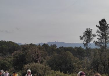
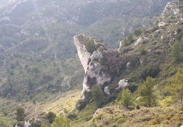
Ce circuit est une autre variante des parcours sur le Pilon du Roi. Après l'ascension au Pilon, on continue avec l'ascension de la tête du Grand Puech. Ensuite, une magnifique descente très cassante et virage de retour au niveau du 'rocher rouge' qui sert de zone d'exercice aux Canadair. Attention, qui dit descente, dit montée et cette dernière ne se fait pas attendre ... heureusement qu'une partie du sol est bîtumé, ça aide vers la fin :-) La deuxième boucle du 'Huit' est terminée maintenant, il ne reste plus qu'à 'boucler' la première via une TRES belle descente qui nous mène à Simiane. Pensez à doser votre effort car il y a pour 34km et n'hésitez pas à boire régulièrement. Ce parcours a été réalisé avec Lolo et Philippe. Nos vélos : rockrider 8.1, 8.2 et 9xc. Bon VTT :-)

Elevation profile

Positioning

Country:
France
Region :
Provence-Alpes-Côte d'Azur
Department/Province :
Bouches-du-Rhône
Municipality :
Simiane-Collongue
Location:
Unknown
Start:(UTM)
695763 ; 4811286 (31T) N.

Trails nearby

Trail Walking Simiane-Collongue - chemin de gui - Photo
Walking
rvdebouc

Walking

Easy
(1)
Simiane-Collongue, Provence-Alpes-Côte d'Azur, Bouches-du-Rhône, France
5.9 km | 8.1 km-effort
1h 45min
Yes
Trail Running Bouc-Bel-Air - Balade à Bouc Bel Air - Photo
Running
tracegps

Running

Medium
(1)
Bouc-Bel-Air, Provence-Alpes-Côte d'Azur, Bouches-du-Rhône, France
6.6 km | 8.7 km-effort
34min
Yes
Trail Mountain bike Bouc-Bel-Air - MOUNINE - Photo
Mountain bike
lemusicoss

Mountain bike

Difficult
(2)
Bouc-Bel-Air, Provence-Alpes-Côte d'Azur, Bouches-du-Rhône, France
20 km | 28 km-effort
3h 0min
Yes
Trail Electric bike Simiane-Collongue - LES MARRES PILON DU ROI - Photo
Electric bike
GUIDE
harydh

Electric bike

Easy
Simiane-Collongue, Provence-Alpes-Côte d'Azur, Bouches-du-Rhône, France
26 km | 36 km-effort
2h 18min
Yes
Trail Walking Bouc-Bel-Air - Bouc bel air - Photo
Walking
sereton

Walking

Medium
Bouc-Bel-Air, Provence-Alpes-Côte d'Azur, Bouches-du-Rhône, France
8.9 km | 11.7 km-effort
2h 44min
Yes
Trail Walking Simiane-Collongue - SityTrail - Etoile-Petit Sanguin - Photo
Walking
MicDul

Walking

Very difficult
Simiane-Collongue, Provence-Alpes-Côte d'Azur, Bouches-du-Rhône, France
14.8 km | 21 km-effort
4h 23min
Yes
Trail Walking Simiane-Collongue - De Simiane-Collongue au Pilon du Roi - Photo
Walking
LtZIP

Walking

Medium
Simiane-Collongue, Provence-Alpes-Côte d'Azur, Bouches-du-Rhône, France
13.6 km | 23 km-effort
4h 44min
No
Trail Walking Septèmes-les-Vallons - grand sanguin petite etoile 415374 gps - Photo
Walking
Nathy8913

Walking

Medium
(1)
Septèmes-les-Vallons, Provence-Alpes-Côte d'Azur, Bouches-du-Rhône, France
10.3 km | 14.8 km-effort
Unknown
Yes
Trail Walking Bouc-Bel-Air - bouc cabries par les crêtes  - Photo
Walking
rvdebouc

Walking

Very easy
(1)
Bouc-Bel-Air, Provence-Alpes-Côte d'Azur, Bouches-du-Rhône, France
3.5 km | 4.7 km-effort
47min
Yes


Close
My subscriptions