Trail Mountain bike Dourgne - La Ronde des Givrés - Photo

La Ronde des Givrés

 tracegps
tracegps

User

© OpenStreetMap contributors
Length
Length
23 km
Max alt
Max alt
819 m
Uphill gradient
Uphill gradient
726 m
Km-Effort
Km-Effort  
33 km
Min alt
Min alt
271 m
Downhill gradient
Downhill gradient
709 m
Boucle
Boucle
No
Creation date :
2014-12-10 00:00:00.0
Updated on :
2014-12-10 00:00:00.0

(0 Reviews)

Mountain bike
Mountain bike
3h00
Difficulty : Difficult

Scan this QR Code to open this trail in the SityTrail application

FREE GPS app for hiking

Logo SityTrail SityTrail

IGN / Geographical institutes

Download SityTrail from the App Store Download SityTrail from Google Play

Logo SityTrail SityTrail World

The world is yours!

Download SityTrail from the App Store Download SityTrail from Google Play Download SityTrail on Huawei AppGallery

About

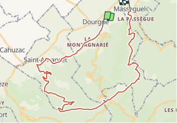
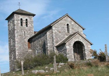
Trail Mountain bike of 23 km to be discovered at Occitania, Tarn, Dourgne. This trail is proposed by tracegps.

Description

Le 26 Novembre 2007 La montagne était toute givrée hier matin avec un zef de nord assez soutenu, il devait faire un -5°C de ressenti. Je me suis pris quelques belles gamelles suite à la fameuse formule : profil négatif   cailloux   humidité   feuilles = gamelle(s) Elle vient de loin cette trace ! !!! Circuit facile en montée par de larges pistes. Descentes difficiles par des sentiers mono traces. Attention descentes très difficiles par temps humide. Arrivé à Massaguel, retour sur dourgne par la route possible (environ 1 Km)

Elevation profile

Positioning

Country:
France
Region :
Occitania
Department/Province :
Tarn
Municipality :
Dourgne
Location:
Unknown
Start:(UTM)
430511 ; 4814775 (31T) N.

Trails nearby

Trail Walking Dourgne - Désert de St Férréol - Photo
Walking
tracegps

Walking

Medium
(1)
Dourgne, Occitania, Tarn, France
7.6 km | 12.1 km-effort
3h 45min
Yes
Trail Electric bike Dourgne - Capelette table orientation  - Photo
Electric bike
NICOLAS VEITH

Electric bike

(1)
Dourgne, Occitania, Tarn, France
21 km | 30 km-effort
1h 59min
No
Trail Walking Dourgne - rando dourgne - Photo
Walking
Mamilaure

Walking

Medium
Dourgne, Occitania, Tarn, France
13 km | 18.5 km-effort
3h 32min
Yes
Trail On foot Sorèze - La boucle du Bois Grand - Photo
On foot
GUIDE+

On foot

Easy
Sorèze, Occitania, Tarn, France
7 km | 10.7 km-effort
2h 26min
Yes
Trail Mountain bike Dourgne - La Croix des fangasse , les Escudiers , arfons  - Photo
Mountain bike
cironav

Mountain bike

Medium
Dourgne, Occitania, Tarn, France
23 km | 0 m-effort
3h 24min
Yes
Trail Walking Dourgne - Dourgne - Revel - Photo
Walking
RR31

Walking

Medium
Dourgne, Occitania, Tarn, France
22 km | 25 km-effort
2h 39min
No
Trail Walking Dourgne - Le désert de St Férréol - Photo
Walking
tracegps

Walking

Medium
Dourgne, Occitania, Tarn, France
7.6 km | 12.1 km-effort
3h 45min
Yes
Trail Mountain bike Verdalle - Taurou-Sant - Photo
Mountain bike
tracegps

Mountain bike

Difficult
Verdalle, Occitania, Tarn, France
38 km | 50 km-effort
3h 30min
Yes
Trail Mountain bike Dourgne - Dourgne, Montagne noire - Photo
Mountain bike
tracegps

Mountain bike

Very difficult
Dourgne, Occitania, Tarn, France
34 km | 49 km-effort
4h 30min
No


Close
My subscriptions