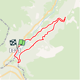
10.2 km | 20 km-effort
Espace VTT FFC Haute Bigorre - Circuit n° 22 - Artigue - Sarrat de Gaye
tracegps
User
Length
7.2 km
Max alt
1294 m
Uphill gradient
276 m
Km-Effort
10.9 km
Min alt
1084 m
Downhill gradient
275 m
Boucle
Yes
Creation date :
2014-12-10 00:00:00.0
Updated on :
2014-12-10 00:00:00.0
1h15
Difficulty : Medium
FREE GPS app for hiking
About
Trail Mountain bike of 7.2 km to be discovered at Occitania, Hautespyrenees, Campan. This trail is proposed by tracegps.
Description
Haute Bigorre Circuit labellisé par la Fédération Française de Cyclisme. Téléchargez le descriptif et le plan.
Positioning
Country:
France
Region :
Occitania
Department/Province :
Hautespyrenees
Municipality :
Campan
Location:
Unknown
Start:(Dec)
Start:(UTM)
271921 ; 4756980 (31T) N.
Comments
Trails nearby
La soula de Tournes
Walking
Easy
(1)
Campan,
Occitania,
Hautespyrenees,
France
7.7 km | 11.3 km-effort
2h 21min
Yes
tourmalet G2 heit
Walking
Very easy
Bagnères-de-Bigorre,
Occitania,
Hautespyrenees,
France
5.5 km | 11.6 km-effort
6h 37min
Yes
SityTrail - 2444920 - artigues-la-mongie-g3-lpc-corrigex
On foot
Very easy
(1)
Campan,
Occitania,
Hautespyrenees,
France
7.8 km | 15.7 km-effort
Unknown
Yes
artigues à payolle
Walking
Very easy
Campan,
Occitania,
Hautespyrenees,
France
15.1 km | 19.8 km-effort
6h 10min
No
Pic Midi Bigorres
Walking
Difficult
(1)
Campan,
Occitania,
Hautespyrenees,
France
9.2 km | 25 km-effort
4h 30min
No
Lac de Gréziolles
Walking
Medium
Bagnères-de-Bigorre,
Occitania,
Hautespyrenees,
France
10.8 km | 21 km-effort
4h 1min
Yes
G2 articles lac de grezillard
Walking
Very difficult
Bagnères-de-Bigorre,
Occitania,
Hautespyrenees,
France
10.4 km | 20 km-effort
7h 18min
Yes
ARTIGUES à PAYOLLE g4 fait "523470"
On foot
Easy
Bagnères-de-Bigorre,
Occitania,
Hautespyrenees,
France
9.9 km | 13.3 km-effort
4h 46min
No