Trail Walking Quarré-les-Tombes - le long de la Cure - Photo
© OpenStreetMap contributors
Length
Length
9.1 km
Max alt
Max alt
399 m
Uphill gradient
Uphill gradient
116 m
Km-Effort
Km-Effort  
10.7 km
Min alt
Min alt
333 m
Downhill gradient
Downhill gradient
117 m
Boucle
Boucle
Yes
Creation date :
2019-01-15 14:09:22.562
Updated on :
2019-01-15 14:09:22.562

(0 Reviews)

Walking
Walking
2h43
Difficulty : Very easy

Scan this QR Code to open this trail in the SityTrail application

FREE GPS app for hiking

Logo SityTrail SityTrail

IGN / Geographical institutes

Download SityTrail from the App Store Download SityTrail from Google Play

Logo SityTrail SityTrail World

The world is yours!

Download SityTrail from the App Store Download SityTrail from Google Play Download SityTrail on Huawei AppGallery

About

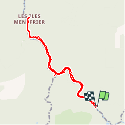
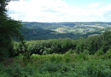
Trail Walking of 9.1 km to be discovered at Bourgogne-Franche-Comté, Yonne, Quarré-les-Tombes. This trail is proposed by alainchardon.

Description

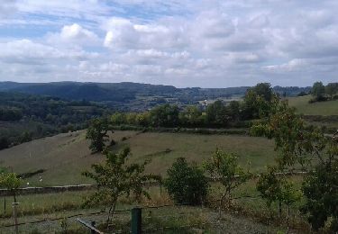
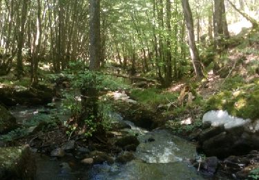
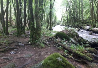
Rando facile le long de la rivière, à l'ombre

Elevation profile

Positioning

Country:
France
Region :
Bourgogne-Franche-Comté
Department/Province :
Yonne
Municipality :
Quarré-les-Tombes
Location:
Unknown
Start:(UTM)
575398 ; 5240629 (31T) N.

Trails nearby

Trail Walking Marigny-l'Église - Marigny l'Eglise, Chalaux - Photo
Walking
nicolibris

Walking

Medium
Marigny-l'Église, Bourgogne-Franche-Comté, Nièvre, France
10.7 km | 15 km-effort
3h 20min
Yes
Trail Walking Saint-Léger-Vauban - Abbaye-Quarre-Abbaye - Photo
Walking
Yannick89

Walking

Very easy
Saint-Léger-Vauban, Bourgogne-Franche-Comté, Yonne, France
19.2 km | 25 km-effort
5h 12min
Yes
Trail Running Saint-Léger-Vauban - la pierre qui vire - Photo
Running
dadodeca

Running

Medium
Saint-Léger-Vauban, Bourgogne-Franche-Comté, Yonne, France
29 km | 39 km-effort
2h 6min
No
Trail Walking Dun-les-Places - Brisson - Photo
Walking
HF89

Walking

Easy
Dun-les-Places, Bourgogne-Franche-Comté, Nièvre, France
11.3 km | 15.3 km-effort
2h 43min
No
Trail Walking Dun-les-Places - Dun les Places - les Iles Menéfrier - Photo
Walking
tracegps

Walking

Difficult
(1)
Dun-les-Places, Bourgogne-Franche-Comté, Nièvre, France
24 km | 34 km-effort
6h 30min
Yes
Trail Mountain bike Marigny-l'Église - Marigny Saulieu - Photo
Mountain bike
Carnzu

Mountain bike

Very difficult
Marigny-l'Église, Bourgogne-Franche-Comté, Nièvre, France
49 km | 62 km-effort
6h 24min
No
Trail Walking Dun-les-Places - forêt de Brésil Cheni - Photo
Walking
marcm

Walking

Very easy
(1)
Dun-les-Places, Bourgogne-Franche-Comté, Nièvre, France
6.3 km | 7.6 km-effort
2h 7min
Yes
Trail Walking Dun-les-Places - RIF-04-22-4 du 19.04.2022 - Photo
Walking
bene_dictus77

Walking

Easy
Dun-les-Places, Bourgogne-Franche-Comté, Nièvre, France
29 km | 36 km-effort
8h 41min
No
Trail Walking Marigny-l'Église - RIF-04-22-3 du 18.04.2022 - Photo
Walking
bene_dictus77

Walking

Easy
Marigny-l'Église, Bourgogne-Franche-Comté, Nièvre, France
14.9 km | 19.5 km-effort
4h 48min
No


Close
My subscriptions