![](/images/other/stat-length.png)
![Trail Walking Granville - Granville - Haute ville - tour des remparts - Photo](https://media.geolcdn.com/t/1900/400/ext.pjpeg?maxdim=2&url=https%3A%2F%2Fstatic1.geolcdn.com%2Fsiteimages%2Fupload%2Ffiles%2F1553511878bg_sport_marche.png)
Granville - Haute ville - tour des remparts
toporient
User
![Length](/images/other/stat-length.png)
Length
3.1 km
![Max alt](https://static1.geolcdn.com/siteimages/upload/files/1508320355ic_sort_altitude_max_24dp.png)
Max alt
43 m
![Uphill gradient](https://static1.geolcdn.com/siteimages/upload/files/1508320355ic_sort_den_pos_24dp.png)
Uphill gradient
57 m
![Km-Effort](/images/other/stat-length.png)
Km-Effort
3.8 km
![Min alt](https://static1.geolcdn.com/siteimages/upload/files/1508320355ic_sort_altitude_min_24dp.png)
Min alt
14 m
![Downhill gradient](https://static1.geolcdn.com/siteimages/upload/files/1508320355ic_sort_den_neg_24dp.png)
Downhill gradient
62 m
![Boucle](https://static1.geolcdn.com/siteimages/upload/files/16400158638029165_repeat_loop_refresh_sync_direction_icon.png)
Boucle
Yes
Creation date :
2019-01-15 14:08:42.225
Updated on :
2019-01-15 14:08:42.225
![Walking](https://static1.geolcdn.com/sitytour/trail-icons/101.png)
50m
Difficulty : Very easy
![Scan this QR Code to open this trail in the SityTrail application](https://capi.geolives.com/qq0zvz2zws4bq2lad0pu/sitytour/trails/1016678/qr.png?size=200)
FREE GPS app for hiking
About
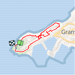
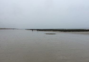
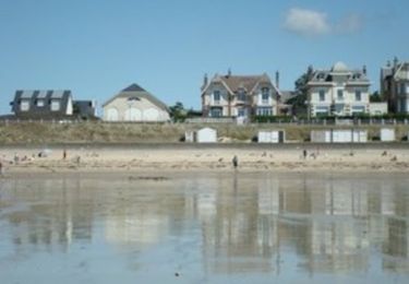
Trail Walking of 3.1 km to be discovered at Normandy, Manche, Granville. This trail is proposed by toporient.
Description
En ville haute, départ du phare de la Pointe du Roc. Suivre le balisage "chemin du littoral" (attention: la partie exposée au sud du phare est actuellement fermée, suivre la déviation qui passe à l'est de celui-ci.)
Positioning
Country:
France
Region :
Normandy
Department/Province :
Manche
Municipality :
Granville
Location:
Unknown
Start:(Dec)
Start:(UTM)
601816 ; 5409954 (30U) N.
Comments
Trails nearby
![Trail Mountain bike Yquelon - La Maximum VTT - Granville - Photo](https://media.geolcdn.com/t/375/260/ext.jpg?maxdim=2&url=https%3A%2F%2Fservices.sitytrail.com%2FGeolivesWS%2FDownloadMedia.ashx%3FTrailID%3D317696%26Media%3D16990_4.jpg)
![Mountain bike Mountain bike](https://static1.geolcdn.com/sitytour/trail-icons/202.png)
La Maximum VTT - Granville
Mountain bike
Difficult
(1)
Yquelon,
Normandy,
Manche,
France
![](/images/other/stat-length.png)
51 km | 61 km-effort
3h 19min
![](https://static1.geolcdn.com/siteimages/upload/files/16400158638029165_repeat_loop_refresh_sync_direction_icon.png)
Yes
![Trail Mountain bike Donville-les-Bains - 50-vtt-donville-21km-200m - Photo](https://media.geolcdn.com/t/375/260/1780a610-d28f-4f7f-bdad-d32483604bd0.jpg&format=jpg&maxdim=2)
![Mountain bike Mountain bike](https://static1.geolcdn.com/sitytour/trail-icons/202.png)
50-vtt-donville-21km-200m
Mountain bike
Medium
Donville-les-Bains,
Normandy,
Manche,
France
![](/images/other/stat-length.png)
21 km | 24 km-effort
1h 39min
![](https://static1.geolcdn.com/siteimages/upload/files/16400158638029165_repeat_loop_refresh_sync_direction_icon.png)
Yes
![Trail Mountain bike Donville-les-Bains - 50-vtt-donville-28km - Photo](https://media.geolcdn.com/t/375/260/283ae410-e7da-45fb-9b33-aeccc3fd5afc.jpg&format=jpg&maxdim=2)
![Mountain bike Mountain bike](https://static1.geolcdn.com/sitytour/trail-icons/202.png)
50-vtt-donville-28km
Mountain bike
Medium
Donville-les-Bains,
Normandy,
Manche,
France
![](/images/other/stat-length.png)
28 km | 31 km-effort
2h 7min
![](https://static1.geolcdn.com/siteimages/upload/files/16400158638029165_repeat_loop_refresh_sync_direction_icon.png)
Yes
![Trail Walking Granville - Balade Granville - Photo](https://media.geolcdn.com/t/375/260/8b72a399-fe7e-420f-99ae-f4196a84bc45.jpg&format=jpg&maxdim=2)
![Walking Walking](https://static1.geolcdn.com/sitytour/trail-icons/101.png)
Balade Granville
Walking
Easy
Granville,
Normandy,
Manche,
France
![](/images/other/stat-length.png)
6.9 km | 8.4 km-effort
1h 44min
![](https://static1.geolcdn.com/siteimages/upload/files/16400158638029165_repeat_loop_refresh_sync_direction_icon.png)
Yes
![Trail Nordic walking Granville - GranvIlle Cap Lihou - Photo](https://media.geolcdn.com/t/375/260/c269533b-8b6f-485d-8c50-20bd82f17d1c.jpg&format=jpg&maxdim=2)
![Nordic walking Nordic walking](https://static1.geolcdn.com/sitytour/trail-icons/102.png)
GranvIlle Cap Lihou
Nordic walking
Medium
Granville,
Normandy,
Manche,
France
![](/images/other/stat-length.png)
7 km | 8.2 km-effort
1h 7min
![](https://static1.geolcdn.com/siteimages/upload/files/16400158638029165_repeat_loop_refresh_sync_direction_icon.png)
Yes
![Trail Walking Donville-les-Bains - Donville Granville - Photo](https://media.geolcdn.com/t/375/260/ext.jpg?maxdim=2&url=https%3A%2F%2Fservices.sitytrail.com%2FGeolivesWS%2FDownloadMedia.ashx%3FTrailID%3D704938%26Media%3Dfix__20170225162805.jpg)
![Walking Walking](https://static1.geolcdn.com/sitytour/trail-icons/101.png)
Donville Granville
Walking
Easy
Donville-les-Bains,
Normandy,
Manche,
France
![](/images/other/stat-length.png)
5.8 km | 7.6 km-effort
1h 31min
![](https://static1.geolcdn.com/siteimages/upload/files/16400158638029165_repeat_loop_refresh_sync_direction_icon.png)
No
![Trail Walking Donville-les-Bains - BALANCE SUR LES PLAGES DE BREVILLE - Photo](https://media.geolcdn.com/t/375/260/ext.jpg?maxdim=2&url=https%3A%2F%2Fservices.sitytrail.com%2FGeolivesWS%2FDownloadMedia.ashx%3FTrailID%3D415348%26Media%3D20150502112556.jpg)
![Walking Walking](https://static1.geolcdn.com/sitytour/trail-icons/101.png)
BALANCE SUR LES PLAGES DE BREVILLE
Walking
Very easy
Donville-les-Bains,
Normandy,
Manche,
France
![](/images/other/stat-length.png)
18.3 km | 19.6 km-effort
4h 40min
![](https://static1.geolcdn.com/siteimages/upload/files/16400158638029165_repeat_loop_refresh_sync_direction_icon.png)
Yes
![Trail Walking Bréville-sur-Mer - Balade à Breville sur Mer - Photo](https://media.geolcdn.com/t/375/260/ext.jpg?maxdim=2&url=https%3A%2F%2Fservices.sitytrail.com%2FGeolivesWS%2FDownloadMedia.ashx%3FTrailID%3D172624%26Media%3D13990_6.jpg)
![Walking Walking](https://static1.geolcdn.com/sitytour/trail-icons/101.png)
Balade à Breville sur Mer
Walking
Medium
Bréville-sur-Mer,
Normandy,
Manche,
France
![](/images/other/stat-length.png)
14.2 km | 15.4 km-effort
3h 0min
![](https://static1.geolcdn.com/siteimages/upload/files/16400158638029165_repeat_loop_refresh_sync_direction_icon.png)
Yes
![Trail Walking Granville - Les chemins de Saint Michel - Granville - Avranches - Photo](https://media.geolcdn.com/t/375/260/ext.jpg?maxdim=2&url=https%3A%2F%2Fservices.sitytrail.com%2FGeolivesWS%2FDownloadMedia.ashx%3FTrailID%3D112749%26Media%3D11880_3.jpg)
![Walking Walking](https://static1.geolcdn.com/sitytour/trail-icons/101.png)
Les chemins de Saint Michel - Granville - Avranches
Walking
Medium
Granville,
Normandy,
Manche,
France
![](/images/other/stat-length.png)
45 km | 52 km-effort
Unknown
![](https://static1.geolcdn.com/siteimages/upload/files/16400158638029165_repeat_loop_refresh_sync_direction_icon.png)
No