Trail Mountain bike Villars - Villars Rustrel - Photo
 tracegps
tracegps

User

© OpenStreetMap contributors
Length
Length
39 km
Max alt
Max alt
574 m
Uphill gradient
Uphill gradient
1007 m
Km-Effort
Km-Effort  
53 km
Min alt
Min alt
281 m
Downhill gradient
Downhill gradient
1015 m
Boucle
Boucle
No
Creation date :
2014-12-10 00:00:00.0
Updated on :
2014-12-10 00:00:00.0

(3 Reviews)

Mountain bike
Mountain bike
3h30
Difficulty : Difficult

Scan this QR Code to open this trail in the SityTrail application

FREE GPS app for hiking

Logo SityTrail SityTrail

IGN / Geographical institutes

Download SityTrail from the App Store Download SityTrail from Google Play

Logo SityTrail SityTrail World

The world is yours!

Download SityTrail from the App Store Download SityTrail from Google Play Download SityTrail on Huawei AppGallery

About

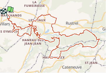
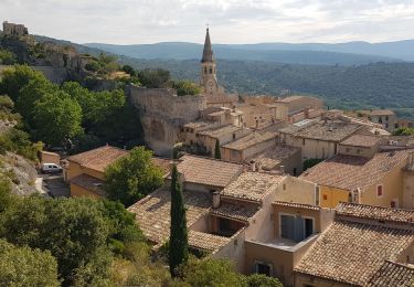
Trail Mountain bike of 39 km to be discovered at Provence-Alpes-Côte d'Azur, Vaucluse, Villars. This trail is proposed by tracegps.

Description

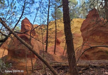
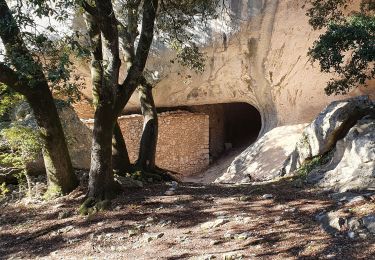
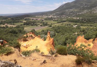
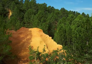
Un superbe parcours dans les orcres du colorado provencal, possibilité de réduire en 25 ou meme 15km. Un passage execptionnel dans une galerie de mine d ocre. Du pur bonheur pour les yeux, de beaux singles en descente et en montée.

Elevation profile

Positioning

Country:
France
Region :
Provence-Alpes-Côte d'Azur
Department/Province :
Vaucluse
Municipality :
Villars
Location:
Unknown
Start:(UTM)
693276 ; 4866959 (31T) N.

Comments

Please log in to post a review or rate the element


tour très sympa.


Peut être superbe mais il faut le matériel adéquat par temps de pluie ou sur terrains gras. Des parties de ruisseaux à traverser difficilement.


Peut être superbe mais il faut le matériel adéquat par temps de pluie ou sur terrains gras. Des parties de ruisseaux à traverser difficilement.


Trails nearby

Trail Walking Villars - Chapelle st Pierre Aiguiers d' Auribeau - Photo
Walking
pieven

Walking

Easy
(1)
Villars, Provence-Alpes-Côte d'Azur, Vaucluse, France
10.9 km | 17.8 km-effort
4h 43min
Yes
Trail Walking Saint-Saturnin-lès-Apt - Tour des Aiguiers-St Saturnin des Apt09-05-23 - Photo
Walking
Christiancordin

Walking

Medium
Saint-Saturnin-lès-Apt, Provence-Alpes-Côte d'Azur, Vaucluse, France
12.1 km | 17.9 km-effort
3h 43min
Yes
Trail Walking Villars - Les Aiguiers du Villars par Cabrone - Photo
Walking
MarcLEBARON

Walking

Difficult
(1)
Villars, Provence-Alpes-Côte d'Azur, Vaucluse, France
17.7 km | 27 km-effort
4h 36min
Yes
Trail Walking Saint-Saturnin-lès-Apt - st saturnin, les Aiguiers Grognards - Photo
Walking
francislassauce

Walking

Difficult
Saint-Saturnin-lès-Apt, Provence-Alpes-Côte d'Azur, Vaucluse, France
10.7 km | 17.5 km-effort
3h 8min
Yes
Trail Walking Villars - Villars Colorado - Photo
Walking
LtZIP

Walking

Easy
Villars, Provence-Alpes-Côte d'Azur, Vaucluse, France
3.3 km | 4.2 km-effort
54min
Yes
Trail Walking Saint-Saturnin-lès-Apt - Sainte Radegonde  - Photo
Walking
POMMEN

Walking

Very easy
(1)
Saint-Saturnin-lès-Apt, Provence-Alpes-Côte d'Azur, Vaucluse, France
4.2 km | 5.9 km-effort
1h 16min
Yes
Trail Walking Saint-Saturnin-lès-Apt - st saturnin d apt - Photo
Walking
jo-ba

Walking

Medium
Saint-Saturnin-lès-Apt, Provence-Alpes-Côte d'Azur, Vaucluse, France
14 km | 21 km-effort
5h 43min
Yes
Trail Walking Saint-Saturnin-lès-Apt - les aigiuer - Photo
Walking
Daniel. Serrre0984@osrange.fr Serre

Walking

Difficult
Saint-Saturnin-lès-Apt, Provence-Alpes-Côte d'Azur, Vaucluse, France
12.4 km | 18.6 km-effort
5h 28min
Yes
Trail Walking Villars - Villars les ocres Jérémy le 20 02 2024 - Photo
Walking
Loli27

Walking

Easy
Villars, Provence-Alpes-Côte d'Azur, Vaucluse, France
3.2 km | 4.4 km-effort
1h 1min
Yes


Close
My subscriptions