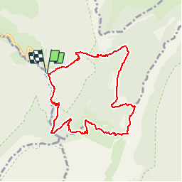
![](/images/other/stat-length.png)
![Trail Walking Saint-Pierre-d'Entremont - Du Cirque de Saint-Même aux crêtes du Grand Manti - Photo](https://media.geolcdn.com/t/1900/400/ext.pjpeg?maxdim=2&url=https%3A%2F%2Fservices.sitytrail.com%2FGeolivesWS%2FDownloadMedia.ashx%3FTrailID%3D101587%26Media%3D1720_1.jpg)
Du Cirque de Saint-Même aux crêtes du Grand Manti
tracegps
User
![Length](/images/other/stat-length.png)
![Max alt](https://static1.geolcdn.com/siteimages/upload/files/1508320355ic_sort_altitude_max_24dp.png)
![Uphill gradient](https://static1.geolcdn.com/siteimages/upload/files/1508320355ic_sort_den_pos_24dp.png)
![Km-Effort](/images/other/stat-length.png)
![Min alt](https://static1.geolcdn.com/siteimages/upload/files/1508320355ic_sort_altitude_min_24dp.png)
![Downhill gradient](https://static1.geolcdn.com/siteimages/upload/files/1508320355ic_sort_den_neg_24dp.png)
![Boucle](https://static1.geolcdn.com/siteimages/upload/files/16400158638029165_repeat_loop_refresh_sync_direction_icon.png)
![Walking](https://static1.geolcdn.com/sitytour/trail-icons/101.png)
5h45
Difficulty : Very difficult
![Scan this QR Code to open this trail in the SityTrail application](https://capi.geolives.com/qq0zvz2zws4bq2lad0pu/sitytour/trails/101587/qr.png?size=200)
FREE GPS app for hiking
About
Trail Walking of 8.6 km to be discovered at Auvergne-Rhône-Alpes, Savoy, Saint-Pierre-d'Entremont. This trail is proposed by tracegps.
Description
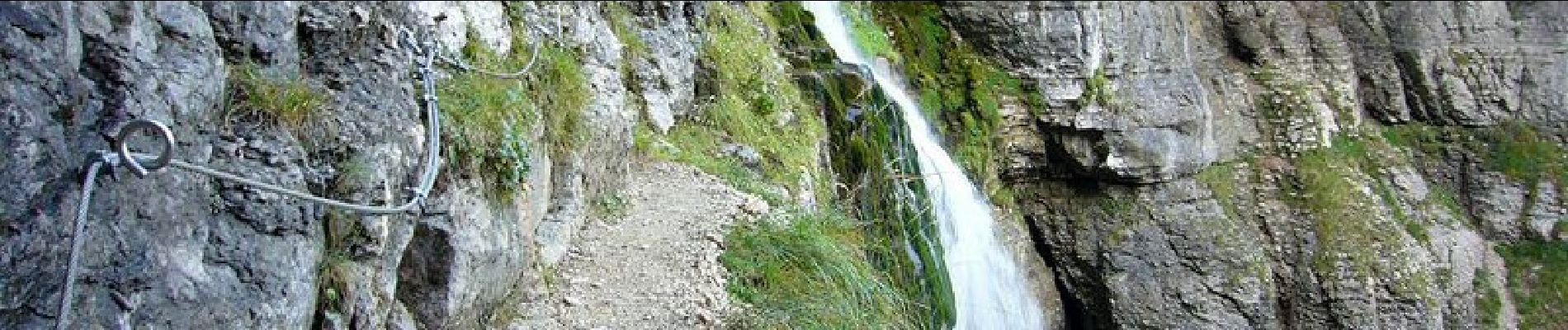
Le Cirque de Saint-Même offre aux randonneurs un paysage d'une grande beauté. Franchir l'impressionnante enceinte de hautes falaises est rendu possible par une succession de passages ancestraux, insolites et surprenants : le pittoresque Pas Ruat à proximité de la résurgence du Guiers, l'improbable Pas de la Mort qui franchit la falaise supérieure pour déboucher presqu'au pied de l'alpage de l'Alpette qui permet de monter facilement jusqu'aux crêtes du Grand Manti. Cet itinéraire bien équipé de mains courantes, de chaînes et d'échelons, nécessite cependant une grande prudence et de l'assurance dans les passages exposés de son parcours. Description complète sur sentier-nature.com : Du Cirque de Saint-Même aux crêtes du Grand Manti Certains passages de cet itinéraire de montagne sont escarpés et/ou très exposés, il est déconseillé aux enfants non accompagnés et aux personnes sujettes au vertige. Pour votre sécurité, nous vous invitons à respecter les règles suivantes : être bien chaussé, ne pas s'engager par mauvais temps, ne pas s'écarter de l'itinéraire ni des sentiers. Pour s'assurer, une corde d'une vingtaine de mètres peut être utile. Il apparaît souhaitable de réaliser cette course par temps sec. Cet itinéraire ce déroule tout ou partie dans la Réserve Naturelle des Hauts de Chartreuse qui a pour mission d'étudier et de gérer ce territoire afin que les diverses activités qui s'y exercent (élevage, exploitation forestière, randonnée, etc.) soient compatibles avec la préservation de la faune, de la flore et du paysage. Participez à la protection de cet espace en respectant la règlementation avec les amis du Parc Naturel régional de Chartreuse.
Positioning
Comments
Trails nearby
![Trail Walking Saint-Pierre-d'Entremont - chartreuse varvats fouda blanc pinet - Photo](https://media.geolcdn.com/t/375/260/3ade212f-cb78-41d4-b551-255bd725eded.jpg&format=jpg&maxdim=2)
![Walking Walking](https://static1.geolcdn.com/sitytour/trail-icons/101.png)
Walking
![](/images/other/stat-length.png)
![](https://static1.geolcdn.com/siteimages/upload/files/16400158638029165_repeat_loop_refresh_sync_direction_icon.png)
![Trail Walking Saint-Pierre-d'Entremont - Le Grand Som 2026m, depuis Saint-Philibert - Photo](https://media.geolcdn.com/t/375/260/ext.jpg?maxdim=2&url=https%3A%2F%2Fservices.sitytrail.com%2FGeolivesWS%2FDownloadMedia.ashx%3FTrailID%3D107472%26Media%3D12415_1.jpg)
![Walking Walking](https://static1.geolcdn.com/sitytour/trail-icons/101.png)
Walking
![](/images/other/stat-length.png)
![](https://static1.geolcdn.com/siteimages/upload/files/16400158638029165_repeat_loop_refresh_sync_direction_icon.png)
![Trail Walking Sainte-Marie-du-Mont - Les Belles Ombres - Sangle et Rochers - Sainte Marie du Mont - Photo](https://media.geolcdn.com/t/375/260/ext.jpg?maxdim=2&url=https%3A%2F%2Fservices.sitytrail.com%2FGeolivesWS%2FDownloadMedia.ashx%3FTrailID%3D106447%26Media%3D10957_1.jpg)
![Walking Walking](https://static1.geolcdn.com/sitytour/trail-icons/101.png)
Walking
![](/images/other/stat-length.png)
![](https://static1.geolcdn.com/siteimages/upload/files/16400158638029165_repeat_loop_refresh_sync_direction_icon.png)
![Trail Snowshoes Saint-Pierre-d'Entremont - La Croix de l'Alpe depuis les Varvats - Photo](https://media.geolcdn.com/t/375/260/ext.jpg?maxdim=2&url=https%3A%2F%2Fservices.sitytrail.com%2FGeolivesWS%2FDownloadMedia.ashx%3FTrailID%3D103120%26Media%3D4867_1.jpg)
![Snowshoes Snowshoes](https://static1.geolcdn.com/sitytour/trail-icons/504.png)
Snowshoes
![](/images/other/stat-length.png)
![](https://static1.geolcdn.com/siteimages/upload/files/16400158638029165_repeat_loop_refresh_sync_direction_icon.png)
![Trail Walking Saint-Pierre-d'Entremont - Roche Veyrand par les Clapiers, 1429m - Photo](https://media.geolcdn.com/t/375/260/ext.jpg?maxdim=2&url=https%3A%2F%2Fservices.sitytrail.com%2FGeolivesWS%2FDownloadMedia.ashx%3FTrailID%3D101734%26Media%3D1981_1.jpg)
![Walking Walking](https://static1.geolcdn.com/sitytour/trail-icons/101.png)
Walking
![](/images/other/stat-length.png)
![](https://static1.geolcdn.com/siteimages/upload/files/16400158638029165_repeat_loop_refresh_sync_direction_icon.png)
![Trail Walking Saint-Vincent-de-Mercuze - 38 cascades d alloix - Photo](https://media.geolcdn.com/t/375/260/ac959965-e9e6-43ac-868c-d1afc5ef4777.jpg&format=jpg&maxdim=2)
![Walking Walking](https://static1.geolcdn.com/sitytour/trail-icons/101.png)
Walking
![](/images/other/stat-length.png)
![](https://static1.geolcdn.com/siteimages/upload/files/16400158638029165_repeat_loop_refresh_sync_direction_icon.png)
![Trail Walking Sainte-Marie-du-Mont - Passage de la Rousse - Photo](https://media.geolcdn.com/t/375/260/3d59ba9c-1b18-4c8b-84d9-d9ac619ac9d2.jpg&format=jpg&maxdim=2)
![Walking Walking](https://static1.geolcdn.com/sitytour/trail-icons/101.png)
Walking
![](/images/other/stat-length.png)
![](https://static1.geolcdn.com/siteimages/upload/files/16400158638029165_repeat_loop_refresh_sync_direction_icon.png)
![Trail Walking Sainte-Marie-du-Mont - Rocher de Belle ombre et ses arches - Photo](https://media.geolcdn.com/t/375/260/d41d4591-aff2-44cd-b615-de2c0388e17f.jpg&format=jpg&maxdim=2)
![Walking Walking](https://static1.geolcdn.com/sitytour/trail-icons/101.png)
Walking
![](/images/other/stat-length.png)
![](https://static1.geolcdn.com/siteimages/upload/files/16400158638029165_repeat_loop_refresh_sync_direction_icon.png)
![Trail Walking Saint-Vincent-de-Mercuze - Grande cascade de Montalieu - Photo](https://media.geolcdn.com/t/375/260/ext.jpg?maxdim=2&url=https%3A%2F%2Fstatic1.geolcdn.com%2Fsiteimages%2Fupload%2Ffiles%2F1553511878bg_sport_marche.png)
![Walking Walking](https://static1.geolcdn.com/sitytour/trail-icons/101.png)
Walking
![](/images/other/stat-length.png)
![](https://static1.geolcdn.com/siteimages/upload/files/16400158638029165_repeat_loop_refresh_sync_direction_icon.png)