![](/images/other/stat-length.png)
![Trail Walking Chalo-Saint-Mars - Chalo St Mars - Photo](https://media.geolcdn.com/t/1900/400/ext.pjpeg?maxdim=2&url=https%3A%2F%2Fservices.sitytrail.com%2FGeolivesWS%2FDownloadMedia.ashx%3FTrailID%3D101558%26Media%3D1669_2.jpg)
Chalo St Mars
tracegps
User
![Length](/images/other/stat-length.png)
Length
9.9 km
![Max alt](https://static1.geolcdn.com/siteimages/upload/files/1508320355ic_sort_altitude_max_24dp.png)
Max alt
148 m
![Uphill gradient](https://static1.geolcdn.com/siteimages/upload/files/1508320355ic_sort_den_pos_24dp.png)
Uphill gradient
202 m
![Km-Effort](/images/other/stat-length.png)
Km-Effort
12.6 km
![Min alt](https://static1.geolcdn.com/siteimages/upload/files/1508320355ic_sort_altitude_min_24dp.png)
Min alt
82 m
![Downhill gradient](https://static1.geolcdn.com/siteimages/upload/files/1508320355ic_sort_den_neg_24dp.png)
Downhill gradient
205 m
![Boucle](https://static1.geolcdn.com/siteimages/upload/files/16400158638029165_repeat_loop_refresh_sync_direction_icon.png)
Boucle
Yes
Creation date :
2014-12-10 00:00:00.0
Updated on :
2014-12-10 00:00:00.0
![Walking](https://static1.geolcdn.com/sitytour/trail-icons/101.png)
3h00
Difficulty : Difficult
![Scan this QR Code to open this trail in the SityTrail application](https://capi.geolives.com/qq0zvz2zws4bq2lad0pu/sitytour/trails/101558/qr.png?size=200)
FREE GPS app for hiking
About
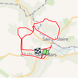
Trail Walking of 9.9 km to be discovered at Ile-de-France, Essonne, Chalo-Saint-Mars. This trail is proposed by tracegps.
Description
Promenade de 10 km à travers ville champs rivière et bois. Durée 3 h00. Vers la ferme du Tronchet foie gras d'Essonne. D’autres informations et photos sont disponibles ICI
Positioning
Country:
France
Region :
Ile-de-France
Department/Province :
Essonne
Municipality :
Chalo-Saint-Mars
Location:
Unknown
Start:(Dec)
Start:(UTM)
431077 ; 5364098 (31U) N.
Comments
Trails nearby
![Trail Walking Saint-Hilaire - Saint-Hilaire - Géosite et abri gravé - Photo](https://media.geolcdn.com/t/375/260/49c381f2-05f7-4d44-acde-f6f5a6dad6fa.jpg&format=jpg&maxdim=2)
![Walking Walking](https://static1.geolcdn.com/sitytour/trail-icons/101.png)
Saint-Hilaire - Géosite et abri gravé
Walking
Medium
Saint-Hilaire,
Ile-de-France,
Essonne,
France
![](/images/other/stat-length.png)
8.4 km | 10.7 km-effort
2h 25min
![](https://static1.geolcdn.com/siteimages/upload/files/16400158638029165_repeat_loop_refresh_sync_direction_icon.png)
Yes
![Trail On foot Chalo-Saint-Mars - Tour Chalo Saint Mars - Photo](https://media.geolcdn.com/t/375/260/0edc8248-a7e9-481b-8422-c4f29bfa8462.jpeg&format=jpg&maxdim=2)
![On foot On foot](https://static1.geolcdn.com/sitytour/trail-icons/100.png)
Tour Chalo Saint Mars
On foot
Easy
Chalo-Saint-Mars,
Ile-de-France,
Essonne,
France
![](/images/other/stat-length.png)
15.3 km | 17.9 km-effort
4h 3min
![](https://static1.geolcdn.com/siteimages/upload/files/16400158638029165_repeat_loop_refresh_sync_direction_icon.png)
No
![Trail Walking Chalo-Saint-Mars - Tours de Chalo saint Mars - Photo](https://media.geolcdn.com/t/375/260/6d365725-29a9-4416-a845-640bdc4b7c45.jpg&format=jpg&maxdim=2)
![Walking Walking](https://static1.geolcdn.com/sitytour/trail-icons/101.png)
Tours de Chalo saint Mars
Walking
Medium
Chalo-Saint-Mars,
Ile-de-France,
Essonne,
France
![](/images/other/stat-length.png)
23 km | 27 km-effort
3h 43min
![](https://static1.geolcdn.com/siteimages/upload/files/16400158638029165_repeat_loop_refresh_sync_direction_icon.png)
Yes
![Trail Walking Chalo-Saint-Mars - 2023-04-05 Rando Chalo Saint Mars - Photo](https://media.geolcdn.com/t/375/260/ext.jpg?maxdim=2&url=https%3A%2F%2Fstatic1.geolcdn.com%2Fsiteimages%2Fupload%2Ffiles%2F1553511878bg_sport_marche.png)
![Walking Walking](https://static1.geolcdn.com/sitytour/trail-icons/101.png)
2023-04-05 Rando Chalo Saint Mars
Walking
Difficult
Chalo-Saint-Mars,
Ile-de-France,
Essonne,
France
![](/images/other/stat-length.png)
11.1 km | 14.3 km-effort
2h 37min
![](https://static1.geolcdn.com/siteimages/upload/files/16400158638029165_repeat_loop_refresh_sync_direction_icon.png)
Yes
![Trail Walking Chalo-Saint-Mars - LA VALLEE DE LA CHALOUETTE 1 - Photo](https://media.geolcdn.com/t/375/260/ext.jpg?maxdim=2&url=https%3A%2F%2Fstatic1.geolcdn.com%2Fsiteimages%2Fupload%2Ffiles%2F1553511878bg_sport_marche.png)
![Walking Walking](https://static1.geolcdn.com/sitytour/trail-icons/101.png)
LA VALLEE DE LA CHALOUETTE 1
Walking
Medium
Chalo-Saint-Mars,
Ile-de-France,
Essonne,
France
![](/images/other/stat-length.png)
4 km | 4.7 km-effort
1h 43min
![](https://static1.geolcdn.com/siteimages/upload/files/16400158638029165_repeat_loop_refresh_sync_direction_icon.png)
Yes
![Trail Trail Chalou-Moulineux - 2020-05-22_12h45m15_Chalou2 - Photo](https://media.geolcdn.com/t/375/260/ext.jpg?maxdim=2&url=https%3A%2F%2Fstatic1.geolcdn.com%2Fsiteimages%2Fupload%2Ffiles%2F1524743154running.jpg)
![Trail Trail](https://static1.geolcdn.com/sitytour/trail-icons/104.png)
2020-05-22_12h45m15_Chalou2
Trail
Medium
Chalou-Moulineux,
Ile-de-France,
Essonne,
France
![](/images/other/stat-length.png)
16.9 km | 21 km-effort
Unknown
![](https://static1.geolcdn.com/siteimages/upload/files/16400158638029165_repeat_loop_refresh_sync_direction_icon.png)
Yes
![Trail Walking Saint-Hilaire - Le chateau du Tronchet - Photo](https://media.geolcdn.com/t/375/260/ext.jpg?maxdim=2&url=https%3A%2F%2Fstatic1.geolcdn.com%2Fsiteimages%2Fupload%2Ffiles%2F1553511878bg_sport_marche.png)
![Walking Walking](https://static1.geolcdn.com/sitytour/trail-icons/101.png)
Le chateau du Tronchet
Walking
Medium
Saint-Hilaire,
Ile-de-France,
Essonne,
France
![](/images/other/stat-length.png)
15.5 km | 18.5 km-effort
4h 1min
![](https://static1.geolcdn.com/siteimages/upload/files/16400158638029165_repeat_loop_refresh_sync_direction_icon.png)
Yes
![Trail Walking Chalo-Saint-Mars - s060915chalochalou - Photo](https://media.geolcdn.com/t/375/260/ext.jpg?maxdim=2&url=https%3A%2F%2Fstatic1.geolcdn.com%2Fsiteimages%2Fupload%2Ffiles%2F1553511878bg_sport_marche.png)
![Walking Walking](https://static1.geolcdn.com/sitytour/trail-icons/101.png)
s060915chalochalou
Walking
Difficult
Chalo-Saint-Mars,
Ile-de-France,
Essonne,
France
![](/images/other/stat-length.png)
25 km | 30 km-effort
6h 29min
![](https://static1.geolcdn.com/siteimages/upload/files/16400158638029165_repeat_loop_refresh_sync_direction_icon.png)
Yes
![Trail Nordic walking Chalo-Saint-Mars - le Tonchet - Photo](https://media.geolcdn.com/t/375/260/ext.jpg?maxdim=2&url=https%3A%2F%2Fstatic1.geolcdn.com%2Fsiteimages%2Fupload%2Ffiles%2F1545311037marcheuse_200dpi.jpg)
![Nordic walking Nordic walking](https://static1.geolcdn.com/sitytour/trail-icons/102.png)
le Tonchet
Nordic walking
Medium
Chalo-Saint-Mars,
Ile-de-France,
Essonne,
France
![](/images/other/stat-length.png)
7.3 km | 9.2 km-effort
1h 48min
![](https://static1.geolcdn.com/siteimages/upload/files/16400158638029165_repeat_loop_refresh_sync_direction_icon.png)
Yes