![](/images/other/stat-length.png)
![Trail Mountain bike Bédarieux - Crête de Bédarieux - Photo](https://media.geolcdn.com/t/1900/400/ext.pjpeg?maxdim=2&url=https%3A%2F%2Fstatic1.geolcdn.com%2Fsiteimages%2Fupload%2Ffiles%2F1524743154velo.jpg)
Crête de Bédarieux
tracegps
User
![Length](/images/other/stat-length.png)
Length
15.8 km
![Max alt](https://static1.geolcdn.com/siteimages/upload/files/1508320355ic_sort_altitude_max_24dp.png)
Max alt
480 m
![Uphill gradient](https://static1.geolcdn.com/siteimages/upload/files/1508320355ic_sort_den_pos_24dp.png)
Uphill gradient
417 m
![Km-Effort](/images/other/stat-length.png)
Km-Effort
21 km
![Min alt](https://static1.geolcdn.com/siteimages/upload/files/1508320355ic_sort_altitude_min_24dp.png)
Min alt
175 m
![Downhill gradient](https://static1.geolcdn.com/siteimages/upload/files/1508320355ic_sort_den_neg_24dp.png)
Downhill gradient
417 m
![Boucle](https://static1.geolcdn.com/siteimages/upload/files/16400158638029165_repeat_loop_refresh_sync_direction_icon.png)
Boucle
Yes
Creation date :
2014-12-10 00:00:00.0
Updated on :
2014-12-10 00:00:00.0
![Mountain bike](https://static1.geolcdn.com/sitytour/trail-icons/202.png)
2h00
Difficulty : Medium
![Scan this QR Code to open this trail in the SityTrail application](https://capi.geolives.com/qq0zvz2zws4bq2lad0pu/sitytour/trails/101548/qr.png?size=200)
FREE GPS app for hiking
About
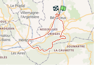
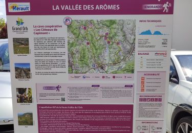
Trail Mountain bike of 15.8 km to be discovered at Occitania, Hérault, Bédarieux. This trail is proposed by tracegps.
Description
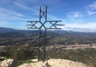
Petite boucle sympa sur les hauteurs de Bédarieux, un joli panorama de la région. Si vous avez un problème avec votre vélo, pensez à CYCLES HORIZON ( 13 AVENUE ABBE TARROUX - BEDARIEUX - Tél : 04.67.95.34.25), un bouclard sympa !
Positioning
Country:
France
Region :
Occitania
Department/Province :
Hérault
Municipality :
Bédarieux
Location:
Unknown
Start:(Dec)
Start:(UTM)
512886 ; 4829540 (31T) N.
Comments
Trails nearby
![Trail Walking Hérépian - herepian pic de Tantajo - Photo](https://media.geolcdn.com/t/375/260/ext.jpg?maxdim=2&url=https%3A%2F%2Fservices.sitytrail.com%2FGeolivesWS%2FDownloadMedia.ashx%3FTrailID%3D656804%26Media%3D20161106140841.jpg)
![Walking Walking](https://static1.geolcdn.com/sitytour/trail-icons/101.png)
herepian pic de Tantajo
Walking
Easy
(1)
Hérépian,
Occitania,
Hérault,
France
![](/images/other/stat-length.png)
13 km | 18.6 km-effort
4h 17min
![](https://static1.geolcdn.com/siteimages/upload/files/16400158638029165_repeat_loop_refresh_sync_direction_icon.png)
Yes
![Trail Cycle Villemagne-l'Argentière - bedarieux. Mons la trivale par la voie verte allé retour - Photo](https://media.geolcdn.com/t/375/260/ext.jpg?maxdim=2&url=https%3A%2F%2Fservices.sitytrail.com%2FGeolivesWS%2FDownloadMedia.ashx%3FTrailID%3D217102%26Media%3D20130827171314.jpg)
![Cycle Cycle](https://static1.geolcdn.com/sitytour/trail-icons/200.png)
bedarieux. Mons la trivale par la voie verte allé retour
Cycle
Very easy
(2)
Villemagne-l'Argentière,
Occitania,
Hérault,
France
![](/images/other/stat-length.png)
31 km | 37 km-effort
3h 11min
![](https://static1.geolcdn.com/siteimages/upload/files/16400158638029165_repeat_loop_refresh_sync_direction_icon.png)
No
![Trail Walking Les Aires - Saint Michel la coquillade - Photo](https://media.geolcdn.com/t/375/260/ext.jpg?maxdim=2&url=https%3A%2F%2Fservices.sitytrail.com%2FGeolivesWS%2FDownloadMedia.ashx%3FTrailID%3D419022%26Media%3Dfix__20150406153326.jpg)
![Walking Walking](https://static1.geolcdn.com/sitytour/trail-icons/101.png)
Saint Michel la coquillade
Walking
Medium
(1)
Les Aires,
Occitania,
Hérault,
France
![](/images/other/stat-length.png)
13.2 km | 21 km-effort
4h 7min
![](https://static1.geolcdn.com/siteimages/upload/files/16400158638029165_repeat_loop_refresh_sync_direction_icon.png)
Yes
![Trail Walking Hérépian - vallée des arômes - Photo](https://media.geolcdn.com/t/375/260/c6753d91-15fa-4844-b595-c6b7592a45cf.jpg&format=jpg&maxdim=2)
![Walking Walking](https://static1.geolcdn.com/sitytour/trail-icons/101.png)
vallée des arômes
Walking
Medium
Hérépian,
Occitania,
Hérault,
France
![](/images/other/stat-length.png)
13.4 km | 17.4 km-effort
3h 11min
![](https://static1.geolcdn.com/siteimages/upload/files/16400158638029165_repeat_loop_refresh_sync_direction_icon.png)
Yes
![Trail Walking Villemagne-l'Argentière - Boussagues - Photo](https://media.geolcdn.com/t/375/260/be08c2e4-1762-4385-aef6-316aec3868b5.jpg&format=jpg&maxdim=2)
![Walking Walking](https://static1.geolcdn.com/sitytour/trail-icons/101.png)
Boussagues
Walking
Medium
Villemagne-l'Argentière,
Occitania,
Hérault,
France
![](/images/other/stat-length.png)
16 km | 22 km-effort
4h 30min
![](https://static1.geolcdn.com/siteimages/upload/files/16400158638029165_repeat_loop_refresh_sync_direction_icon.png)
Yes
![Trail Walking Les Aires - les aires, chapelle Saint Michel - Photo](https://media.geolcdn.com/t/375/260/5794cff5-7317-4fba-a64f-d491ed24084c.jpg&format=jpg&maxdim=2)
![Walking Walking](https://static1.geolcdn.com/sitytour/trail-icons/101.png)
les aires, chapelle Saint Michel
Walking
Medium
Les Aires,
Occitania,
Hérault,
France
![](/images/other/stat-length.png)
7.6 km | 11.4 km-effort
3h 25min
![](https://static1.geolcdn.com/siteimages/upload/files/16400158638029165_repeat_loop_refresh_sync_direction_icon.png)
Yes
![Trail Walking Bédarieux - Moulins de faugeres - Photo](https://media.geolcdn.com/t/375/260/b3764dc8-fe17-44a1-b048-1c1d073310cb.jpg&format=jpg&maxdim=2)
![Walking Walking](https://static1.geolcdn.com/sitytour/trail-icons/101.png)
Moulins de faugeres
Walking
Easy
Bédarieux,
Occitania,
Hérault,
France
![](/images/other/stat-length.png)
13.3 km | 17.5 km-effort
3h 36min
![](https://static1.geolcdn.com/siteimages/upload/files/16400158638029165_repeat_loop_refresh_sync_direction_icon.png)
Yes
![Trail Walking Faugères - La Caumette- Pic du Tantajo - Photo](https://media.geolcdn.com/t/375/260/a3bc5e44-6b9f-4ff4-a63f-d3f7e92231db.jpg&format=jpg&maxdim=2)
![Walking Walking](https://static1.geolcdn.com/sitytour/trail-icons/101.png)
La Caumette- Pic du Tantajo
Walking
Difficult
(1)
Faugères,
Occitania,
Hérault,
France
![](/images/other/stat-length.png)
13 km | 18.7 km-effort
4h 59min
![](https://static1.geolcdn.com/siteimages/upload/files/16400158638029165_repeat_loop_refresh_sync_direction_icon.png)
Yes
![Trail Walking Les Aires - la coquillage et saint michel - Photo](https://media.geolcdn.com/t/375/260/2c99762b-b4fb-4a37-b9fb-706d8d94b4c4.jpg&format=jpg&maxdim=2)
![Walking Walking](https://static1.geolcdn.com/sitytour/trail-icons/101.png)
la coquillage et saint michel
Walking
Medium
Les Aires,
Occitania,
Hérault,
France
![](/images/other/stat-length.png)
11.9 km | 19.7 km-effort
3h 47min
![](https://static1.geolcdn.com/siteimages/upload/files/16400158638029165_repeat_loop_refresh_sync_direction_icon.png)
Yes