Trail Walking Bilhères - Cromlech de lou Couraus - Photo
 tracegps
tracegps

User

© OpenStreetMap contributors
Length
Length
4.2 km
Max alt
Max alt
978 m
Uphill gradient
Uphill gradient
172 m
Km-Effort
Km-Effort  
6.4 km
Min alt
Min alt
830 m
Downhill gradient
Downhill gradient
164 m
Boucle
Boucle
Yes
Creation date :
2014-12-10 00:00:00.0
Updated on :
2014-12-10 00:00:00.0

(1 Reviews)

Walking
Walking
1h45
Difficulty : Medium

Scan this QR Code to open this trail in the SityTrail application

FREE GPS app for hiking

Logo SityTrail SityTrail

IGN / Geographical institutes

Download SityTrail from the App Store Download SityTrail from Google Play

Logo SityTrail SityTrail World

The world is yours!

Download SityTrail from the App Store Download SityTrail from Google Play Download SityTrail on Huawei AppGallery

About

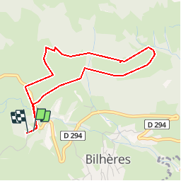
Trail Walking of 4.2 km to be discovered at New Aquitaine, Pyrénées-Atlantiques, Bilhères. This trail is proposed by tracegps.

Description

Un circuit sympathique à parcourir en famille avant d'aller profiter d'un pique-nique au bord du ruiseau (à proximité du parking).

Elevation profile

Photos

Points of interest

Point of interest Bilhères - WAY8 - Photo
tracegps
BILHÈRES 

Positioning

Country:
France
Region :
New Aquitaine
Department/Province :
Pyrénées-Atlantiques
Municipality :
Bilhères
Location:
Unknown
Start:(UTM)
707002 ; 4770758 (30T) N.

Comments

Please log in to post a review or rate the element


Trails nearby

Trail Walking Louvie-Juzon - Soum de las Picarras Montagne du Rey - Photo
Walking
DuMarsan

Walking

Easy
(1)
Louvie-Juzon, New Aquitaine, Pyrénées-Atlantiques, France
12.2 km | 25 km-effort
5h 16min
Yes
Trail Walking Bielle - Pics de Cambeilh et petit Gerbe  - Photo
Walking
DuMarsan

Walking

Easy
(1)
Bielle, New Aquitaine, Pyrénées-Atlantiques, France
13.7 km | 27 km-effort
5h 24min
Yes
Trail Walking Bielle - BIELLE l arriu Mage reco  3443541 - Photo
Walking
GUIDE
marmotte65

Walking

Difficult
Bielle, New Aquitaine, Pyrénées-Atlantiques, France
8.7 km | 14.7 km-effort
2h 47min
Yes
Trail On foot Gère-Bélesten - La fontaine d'Esteret - Photo
On foot
GUIDE+

On foot

Easy
Gère-Bélesten, New Aquitaine, Pyrénées-Atlantiques, France
3.7 km | 7.6 km-effort
1h 43min
Yes
Trail On foot Bielle - L'Arriu-Mage - Photo
On foot
GUIDE+

On foot

Easy
Bielle, New Aquitaine, Pyrénées-Atlantiques, France
8 km | 14 km-effort
3h 10min
Yes
Trail On foot Bilhères - Les cercles de pierre (Bilhères) - Photo
On foot
GUIDE+

On foot

Easy
Bilhères, New Aquitaine, Pyrénées-Atlantiques, France
7.2 km | 11.6 km-effort
2h 37min
Yes
Trail On foot Bilhères - Les cabanes de Lasbordes - Photo
On foot
GUIDE+

On foot

Easy
Bilhères, New Aquitaine, Pyrénées-Atlantiques, France
11.2 km | 19.7 km-effort
4h 28min
Yes
Trail On foot Louvie-Juzon - Le piémont du Rey - Photo
On foot
GUIDE+

On foot

Easy
Louvie-Juzon, New Aquitaine, Pyrénées-Atlantiques, France
3.5 km | 10.2 km-effort
2h 19min
No
Trail On foot Arudy - Le tour du bassin d'Arudy - Photo
On foot
GUIDE+

On foot

Medium
Arudy, New Aquitaine, Pyrénées-Atlantiques, France
19.2 km | 27 km-effort
6h 7min
Yes


Close
My subscriptions