Trail Mountain bike Montpouillan - Montpouillan variante 2 enduro léger à Vtt - Photo

Montpouillan variante 2 enduro léger à Vtt

 tracegps
tracegps

User

© OpenStreetMap contributors
Length
Length
21 km
Max alt
Max alt
124 m
Uphill gradient
Uphill gradient
317 m
Km-Effort
Km-Effort  
25 km
Min alt
Min alt
24 m
Downhill gradient
Downhill gradient
317 m
Boucle
Boucle
Yes
Creation date :
2014-12-10 00:00:00.0
Updated on :
2014-12-10 00:00:00.0

(0 Reviews)

Mountain bike
Mountain bike
1h30
Difficulty : Difficult

Scan this QR Code to open this trail in the SityTrail application

FREE GPS app for hiking

Logo SityTrail SityTrail

IGN / Geographical institutes

Download SityTrail from the App Store Download SityTrail from Google Play

Logo SityTrail SityTrail World

The world is yours!

Download SityTrail from the App Store Download SityTrail from Google Play Download SityTrail on Huawei AppGallery

About

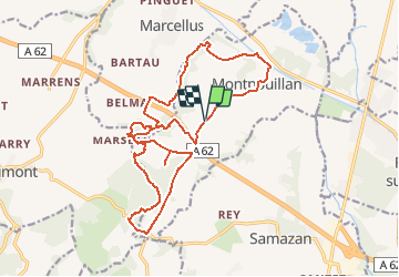
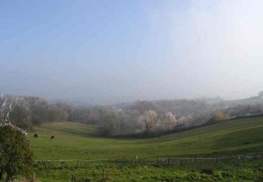
Trail Mountain bike of 21 km to be discovered at New Aquitaine, Lot-et-Garonne, Montpouillan. This trail is proposed by tracegps.

Description

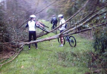
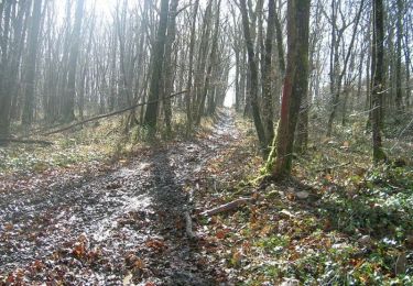
Attention : pour ceux qui voudraient faire se circuit à Vtt, il faut avoir une certaine expérience car certains passages ne sont pas faciles et assez techniques ! Comme je suis de Montpouillan, je vous conseille de commencer le circuit en partant de la place de Montpouillan. Vous allez suivre la direction du cimetière et sur sa droite vous commencerez la première boucle du circuit, puis vous suivez le tracé gps tout simplement. Ensuite, vous arriverez sur la 2ème portion du circuit,et il va falloir aller chercher le début de la 2ème boucle, donc vous suivez direction Guérin, vous monterez une cote et ensuite un faux plat mais sur route. Environ 3 km et vous entrerez dans le Bois de Montpouillan "bastard" et la, vous suivez le tracé gps. C'est un ancien ruisseau qui est à sec depuis très longtemps, si vous faites attention au fond du fossé, vous pouvez vous amusez un peu en regardant sur les cotés. En sortant de cette deuxième boucle, prenez à gauche et à droite sur la route direction Marcellus. Vous ferez 500 m sur la route et dans une côte suivez bien le tracé gps car ça bifurque sur la droite, et il peut arriver que l'entrée soit cachée par du feuillage. Rentrez dedans , ensuite traversez le ruisseau c'est faisable à pied et à vélo sans problème. Après, vous remonterez le long de l'autoroute et vous aurez fini le circuit dans les bois. Il ne vous reste plus qu’à rentrer jusqu'à la place du village.

Elevation profile

Positioning

Country:
France
Region :
New Aquitaine
Department/Province :
Lot-et-Garonne
Municipality :
Montpouillan
Location:
Unknown
Start:(UTM)
268448 ; 4927078 (31T) N.

Trails nearby

Trail Mountain bike Montpouillan - Montpouillan variante 1 - Photo
Mountain bike
tracegps

Mountain bike

Very difficult
Montpouillan, New Aquitaine, Lot-et-Garonne, France
41 km | 49 km-effort
2h 30min
No
Trail Mountain bike Marcellus - Marcellus et la Vénus de Milo - Pays Val de Garonne - Gascogne - Photo
Mountain bike
tracegps

Mountain bike

Easy
Marcellus, New Aquitaine, Lot-et-Garonne, France
4.9 km | 5.8 km-effort
40min
Yes
Trail Walking Marcellus - Marcellus et la Vénus de Milo - Pays Val de Garonne - Gascogne - Photo
Walking
tracegps

Walking

Easy
Marcellus, New Aquitaine, Lot-et-Garonne, France
4.9 km | 5.8 km-effort
1h 40min
Yes
Trail Mountain bike Gaujac - Gaujac, un village de plaine entre la Garonne et son Canal - Pays Val de Garonne - Gascogne - Photo
Mountain bike
tracegps

Mountain bike

Medium
Gaujac, New Aquitaine, Lot-et-Garonne, France
9.2 km | 10.1 km-effort
1h 19min
Yes
Trail Walking Gaujac - Gaujac, un village de plaine entre la Garonne et son Canal - Pays Val de Garonne - Gascogne - Photo
Walking
tracegps

Walking

Medium
Gaujac, New Aquitaine, Lot-et-Garonne, France
9.2 km | 10.1 km-effort
2h 45min
Yes
Trail Walking Cocumont - Goutx, site panoramique de Cocumont - Pays Val de Garonne - Gascogne - Photo
Walking
tracegps

Walking

Easy
Cocumont, New Aquitaine, Lot-et-Garonne, France
3.4 km | 4.5 km-effort
1h 0min
Yes
Trail Mountain bike Montpouillan - Marmande  - Photo
Mountain bike
tracegps

Mountain bike

Difficult
Montpouillan, New Aquitaine, Lot-et-Garonne, France
25 km | 29 km-effort
3h 0min
Yes
Trail Walking Montpouillan - Montpouillan variante 2 enduro léger à Vtt - Photo
Walking
tracegps

Walking

Very difficult
Montpouillan, New Aquitaine, Lot-et-Garonne, France
21 km | 25 km-effort
4h 0min
Yes
Trail Walking Cocumont - Goutz 3 églises  - Photo
Walking
Patrice47200

Walking

Medium
Cocumont, New Aquitaine, Lot-et-Garonne, France
13.4 km | 16.7 km-effort
3h 28min
Yes


Close
My subscriptions