![](/images/other/stat-length.png)
![Trail Mountain bike Chazelles - Rando VTT 20 km Chazelles 2007 - Photo](https://media.geolcdn.com/t/1900/400/ext.pjpeg?maxdim=2&url=https%3A%2F%2Fstatic1.geolcdn.com%2Fsiteimages%2Fupload%2Ffiles%2F1524743154velo.jpg)
Rando VTT 20 km Chazelles 2007
tracegps
User
![Length](/images/other/stat-length.png)
![Max alt](https://static1.geolcdn.com/siteimages/upload/files/1508320355ic_sort_altitude_max_24dp.png)
![Uphill gradient](https://static1.geolcdn.com/siteimages/upload/files/1508320355ic_sort_den_pos_24dp.png)
![Km-Effort](/images/other/stat-length.png)
![Min alt](https://static1.geolcdn.com/siteimages/upload/files/1508320355ic_sort_altitude_min_24dp.png)
![Downhill gradient](https://static1.geolcdn.com/siteimages/upload/files/1508320355ic_sort_den_neg_24dp.png)
![Boucle](https://static1.geolcdn.com/siteimages/upload/files/16400158638029165_repeat_loop_refresh_sync_direction_icon.png)
![Mountain bike](https://static1.geolcdn.com/sitytour/trail-icons/202.png)
2h19
Difficulty : Medium
![Scan this QR Code to open this trail in the SityTrail application](https://capi.geolives.com/qq0zvz2zws4bq2lad0pu/sitytour/trails/101484/qr.png?size=200)
FREE GPS app for hiking
About
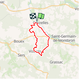
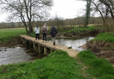
Trail Mountain bike of 18.1 km to be discovered at New Aquitaine, Charente, Chazelles. This trail is proposed by tracegps.
Description
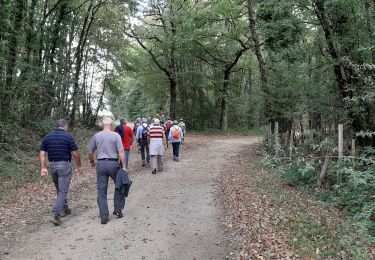
Ceci était un des circuits de la rando VTT de Chazelles en 2007. Départ du stade de foot. Un départ en côte puis une traversé de champ au début. Le reste du cicuit se compose de grands chemins et de monotraces en sous bois. Le retour se fait sur une ancienne ligne de chemin de fer amménagée pour la randonnée. Bonne prommenade.
Positioning
Comments
Trails nearby
![Trail Walking Pranzac - Pranzac et ses petits villages. - Photo](https://media.geolcdn.com/t/375/260/3a77c9e3-0523-4318-8510-a2c1a4b859f3.jpg&format=jpg&maxdim=2)
![Walking Walking](https://static1.geolcdn.com/sitytour/trail-icons/101.png)
Walking
![](/images/other/stat-length.png)
![](https://static1.geolcdn.com/siteimages/upload/files/16400158638029165_repeat_loop_refresh_sync_direction_icon.png)
![Trail Walking Chazelles - Les Grottes du Quéroy -gros terme et Combe - Photo](https://media.geolcdn.com/t/375/260/a902d7b3-47f7-4cd6-b06e-56e13f719b7b.jpg&format=jpg&maxdim=2)
![Walking Walking](https://static1.geolcdn.com/sitytour/trail-icons/101.png)
Walking
![](/images/other/stat-length.png)
![](https://static1.geolcdn.com/siteimages/upload/files/16400158638029165_repeat_loop_refresh_sync_direction_icon.png)
![Trail Walking Bunzac - BUNZAC 16110 ..départ de Puy cocu > combebrune > les Denis > le château des deffends - Photo](https://media.geolcdn.com/t/375/260/7d0ff8b1-963c-44bc-be90-151320ae11e3.jpg&format=jpg&maxdim=2)
![Walking Walking](https://static1.geolcdn.com/sitytour/trail-icons/101.png)
Walking
![](/images/other/stat-length.png)
![](https://static1.geolcdn.com/siteimages/upload/files/16400158638029165_repeat_loop_refresh_sync_direction_icon.png)
![Trail Walking Moulins-sur-Tardoire - La rando de Vilhoneur côté Nord - Photo](https://media.geolcdn.com/t/375/260/c9220340-558b-478c-9a23-ab29d5a7cbe3.jpg&format=jpg&maxdim=2)
![Walking Walking](https://static1.geolcdn.com/sitytour/trail-icons/101.png)
Walking
![](/images/other/stat-length.png)
![](https://static1.geolcdn.com/siteimages/upload/files/16400158638029165_repeat_loop_refresh_sync_direction_icon.png)
![Trail Walking Chazelles - La randonnée autour de Chazelles - Photo](https://media.geolcdn.com/t/375/260/6a56e3fd-00be-447e-b74c-a7c93873ee51.jpg&format=jpg&maxdim=2)
![Walking Walking](https://static1.geolcdn.com/sitytour/trail-icons/101.png)
Walking
![](/images/other/stat-length.png)
![](https://static1.geolcdn.com/siteimages/upload/files/16400158638029165_repeat_loop_refresh_sync_direction_icon.png)
![Trail Mountain bike Chazelles - Chazelles - Brégout - Photo](https://media.geolcdn.com/t/375/260/ext.jpg?maxdim=2&url=https%3A%2F%2Fstatic1.geolcdn.com%2Fsiteimages%2Fupload%2Ffiles%2F1524743154velo.jpg)
![Mountain bike Mountain bike](https://static1.geolcdn.com/sitytour/trail-icons/202.png)
Mountain bike
![](/images/other/stat-length.png)
![](https://static1.geolcdn.com/siteimages/upload/files/16400158638029165_repeat_loop_refresh_sync_direction_icon.png)
![Trail Walking Bunzac - Départ de puy cocu et les petits villages autour de Pranzac 16 110 - Photo](https://media.geolcdn.com/t/375/260/3a6a783b-5767-4811-845d-75faa28604c8.jpg&format=jpg&maxdim=2)
![Walking Walking](https://static1.geolcdn.com/sitytour/trail-icons/101.png)
Walking
![](/images/other/stat-length.png)
![](https://static1.geolcdn.com/siteimages/upload/files/16400158638029165_repeat_loop_refresh_sync_direction_icon.png)
![Trail Walking Moulins-sur-Tardoire - Vilhonneur0504 - Photo](https://media.geolcdn.com/t/375/260/5373ed4e-d465-4437-8c4c-df16ce9bb694.jpg&format=jpg&maxdim=2)
![Walking Walking](https://static1.geolcdn.com/sitytour/trail-icons/101.png)
Walking
![](/images/other/stat-length.png)
![](https://static1.geolcdn.com/siteimages/upload/files/16400158638029165_repeat_loop_refresh_sync_direction_icon.png)
![Trail Walking Chazelles - Les grottes du Queroy en passant par le pont Romain de Gros Terme - Photo](https://media.geolcdn.com/t/375/260/ext.jpg?maxdim=2&url=https%3A%2F%2Fservices.sitytrail.com%2FGeolivesWS%2FDownloadMedia.ashx%3FTrailID%3D716486%26Media%3Dfix__20170319104404.jpg)
![Walking Walking](https://static1.geolcdn.com/sitytour/trail-icons/101.png)
Walking
![](/images/other/stat-length.png)
![](https://static1.geolcdn.com/siteimages/upload/files/16400158638029165_repeat_loop_refresh_sync_direction_icon.png)