Trail Mountain bike Gontaud-de-Nogaret - Gontaud de Nogaret - Photo
 tracegps
tracegps

User

© OpenStreetMap contributors
Length
Length
33 km
Max alt
Max alt
135 m
Uphill gradient
Uphill gradient
656 m
Km-Effort
Km-Effort  
42 km
Min alt
Min alt
33 m
Downhill gradient
Downhill gradient
656 m
Boucle
Boucle
Yes
Creation date :
2014-12-10 00:00:00.0
Updated on :
2014-12-10 00:00:00.0

(0 Reviews)

Mountain bike
Mountain bike
3h00
Difficulty : Difficult

Scan this QR Code to open this trail in the SityTrail application

FREE GPS app for hiking

Logo SityTrail SityTrail

IGN / Geographical institutes

Download SityTrail from the App Store Download SityTrail from Google Play

Logo SityTrail SityTrail World

The world is yours!

Download SityTrail from the App Store Download SityTrail from Google Play Download SityTrail on Huawei AppGallery

About

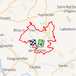
Trail Mountain bike of 33 km to be discovered at New Aquitaine, Lot-et-Garonne, Gontaud-de-Nogaret. This trail is proposed by tracegps.

Description

Le départ du circuit se fait depuis la place de la mairie de Gontaud de Nogaret (47). Le circuit n'est pas trop technique avec des passages au bord de 3 lacs assez sympa. On y trouve pas mal de descente mais sans plus pour le technique. Terrain plutôt sableux au début puis de la terre, donc à préférer quand c'est sec, mais c'est une rando à faire !

Elevation profile

Positioning

Country:
France
Region :
New Aquitaine
Department/Province :
Lot-et-Garonne
Municipality :
Gontaud-de-Nogaret
Location:
Unknown
Start:(UTM)
284800 ; 4926028 (31T) N.

Trails nearby

Trail Walking Hautesvignes - 2013HautesvignesVillage - Photo
Walking
garigotte

Walking

Medium
(2)
Hautesvignes, New Aquitaine, Lot-et-Garonne, France
8.2 km | 11.1 km-effort
2h 21min
Yes
Trail Equestrian Gontaud-de-Nogaret - Bistauzac, une succession de points de vue - Pays Val de Garonne - Gascogne - Photo
Equestrian
tracegps

Equestrian

Medium
Gontaud-de-Nogaret, New Aquitaine, Lot-et-Garonne, France
12.7 km | 15.8 km-effort
2h 15min
Yes
Trail Mountain bike Gontaud-de-Nogaret - Bistauzac, une succession de points de vue - Pays Val de Garonne - Gascogne - Photo
Mountain bike
tracegps

Mountain bike

Medium
(1)
Gontaud-de-Nogaret, New Aquitaine, Lot-et-Garonne, France
12.7 km | 15.8 km-effort
1h 45min
Yes
Trail Walking Gontaud-de-Nogaret - Bistauzac, une succession de points de vue - Pays Val de Garonne - Gascogne - Photo
Walking
tracegps

Walking

Medium
Gontaud-de-Nogaret, New Aquitaine, Lot-et-Garonne, France
12.7 km | 15.8 km-effort
3h 19min
Yes
Trail Equestrian Gontaud-de-Nogaret - Gontaud-de-Nogaret, la balade du Moulin de Gibra - Pays Val de Garonne - Gascogne - Photo
Equestrian
tracegps

Equestrian

Medium
Gontaud-de-Nogaret, New Aquitaine, Lot-et-Garonne, France
8 km | 10.5 km-effort
1h 19min
Yes
Trail Mountain bike Gontaud-de-Nogaret - Gontaud-de-Nogaret, la balade du Moulin de Gibra - Pays Val de Garonne - Gascogne - Photo
Mountain bike
tracegps

Mountain bike

Medium
Gontaud-de-Nogaret, New Aquitaine, Lot-et-Garonne, France
8 km | 10.5 km-effort
1h 0min
Yes
Trail Walking Gontaud-de-Nogaret - Gontaud-de-Nogaret, la balade du Moulin de Gibra - Pays Val de Garonne - Gascogne - Photo
Walking
tracegps

Walking

Medium
Gontaud-de-Nogaret, New Aquitaine, Lot-et-Garonne, France
8 km | 10.5 km-effort
2h 34min
Yes
Trail Equestrian Birac-sur-Trec - Birac-sur-Trec, des coteaux à la plaine de Garonne - Pays Val de Garonne - Gascogne - Photo
Equestrian
tracegps

Equestrian

Medium
Birac-sur-Trec, New Aquitaine, Lot-et-Garonne, France
10.7 km | 13.3 km-effort
2h 0min
Yes
Trail Mountain bike Birac-sur-Trec - Birac-sur-Trec, des coteaux à la plaine de Garonne - Pays Val de Garonne - Gascogne - Photo
Mountain bike
tracegps

Mountain bike

Medium
Birac-sur-Trec, New Aquitaine, Lot-et-Garonne, France
10.7 km | 13.3 km-effort
1h 30min
Yes


Close
My subscriptions