Trail Mountain bike Montclus - Vaugela - Photo
 tracegps
tracegps

User

© OpenStreetMap contributors
Length
Length
11.2 km
Max alt
Max alt
1202 m
Uphill gradient
Uphill gradient
512 m
Km-Effort
Km-Effort  
18 km
Min alt
Min alt
704 m
Downhill gradient
Downhill gradient
518 m
Boucle
Boucle
Yes
Creation date :
2014-12-10 00:00:00.0
Updated on :
2014-12-10 00:00:00.0

(0 Reviews)

Mountain bike
Mountain bike
1h15
Difficulty : Very difficult

Scan this QR Code to open this trail in the SityTrail application

FREE GPS app for hiking

Logo SityTrail SityTrail

IGN / Geographical institutes

Download SityTrail from the App Store Download SityTrail from Google Play

Logo SityTrail SityTrail World

The world is yours!

Download SityTrail from the App Store Download SityTrail from Google Play Download SityTrail on Huawei AppGallery

About

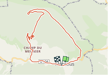
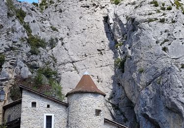
Trail Mountain bike of 11.2 km to be discovered at Provence-Alpes-Côte d'Azur, Hautes-Alpes, Montclus. This trail is proposed by tracegps.

Description

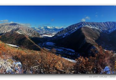
Belle montee par la piste et une descente enduro des plus "tagazoux" mais tout passe sur le velo. Pour une bonne bouffe ou un gite local, réserver à Vaugela auberge Montclus.

Elevation profile

Positioning

Country:
France
Region :
Provence-Alpes-Côte d'Azur
Department/Province :
Hautes-Alpes
Municipality :
Montclus
Location:
Unknown
Start:(UTM)
713442 ; 4921385 (31T) N.

Trails nearby

Trail Walking Serres - Tour des Baronnies du Buëch - Serres - Montmorin - Photo
Walking
tracegps

Walking

Difficult
(1)
Serres, Provence-Alpes-Côte d'Azur, Hautes-Alpes, France
20 km | 33 km-effort
4h 0min
No
Trail Walking Sigottier - Le Duffre - Photo
Walking
GUIDE
Marco05

Walking

Medium
Sigottier, Provence-Alpes-Côte d'Azur, Hautes-Alpes, France
10.3 km | 19.1 km-effort
4h 19min
Yes
Trail Walking Serres - Rocher de Jardanne - Photo
Walking
GUIDE
Marco05

Walking

Medium
Serres, Provence-Alpes-Côte d'Azur, Hautes-Alpes, France
10.4 km | 19.8 km-effort
4h 30min
Yes
Trail Walking Serres - Rocher de Beaumont - Photo
Walking
GUIDE
Marco05

Walking

Difficult
Serres, Provence-Alpes-Côte d'Azur, Hautes-Alpes, France
11.3 km | 23 km-effort
5h 19min
No
Trail Walking Serres - Arambre - Photo
Walking
GUIDE
Marco05

Walking

Difficult
Serres, Provence-Alpes-Côte d'Azur, Hautes-Alpes, France
6.8 km | 16.9 km-effort
3h 50min
Yes
Trail Walking Serres - R32   Au dessus de Serres - Photo
Walking
GUIDE+

Walking

Medium
Serres, Provence-Alpes-Côte d'Azur, Hautes-Alpes, France
5.4 km | 10.5 km-effort
2h 8min
Yes
Trail Walking Sigottier - Boucle des Michons Départ Sigottier 322+ - Photo
Walking
claude nier

Walking

Easy
Sigottier, Provence-Alpes-Côte d'Azur, Hautes-Alpes, France
8.8 km | 13.1 km-effort
3h 20min
Yes
Trail Walking Serres - 20191212_Serres - Les Trois Boucles - Photo
Walking
PapouBertrand

Walking

Medium
Serres, Provence-Alpes-Côte d'Azur, Hautes-Alpes, France
20 km | 34 km-effort
7h 51min
Yes
Trail Walking Sigottier - R35   La Montagne - Photo
Walking
GUIDE+

Walking

Medium
Sigottier, Provence-Alpes-Côte d'Azur, Hautes-Alpes, France
10.5 km | 18 km-effort
3h 40min
Yes


Close
My subscriptions