![](/images/other/stat-length.png)
![Trail Mountain bike Feyzin - Ile de la Table ronde - Photo](https://media.geolcdn.com/t/1900/400/ext.pjpeg?maxdim=2&url=https%3A%2F%2Fstatic1.geolcdn.com%2Fsiteimages%2Fupload%2Ffiles%2F1524743154velo.jpg)
Ile de la Table ronde
tracegps
User
![Length](/images/other/stat-length.png)
![Max alt](https://static1.geolcdn.com/siteimages/upload/files/1508320355ic_sort_altitude_max_24dp.png)
![Uphill gradient](https://static1.geolcdn.com/siteimages/upload/files/1508320355ic_sort_den_pos_24dp.png)
![Km-Effort](/images/other/stat-length.png)
![Min alt](https://static1.geolcdn.com/siteimages/upload/files/1508320355ic_sort_altitude_min_24dp.png)
![Downhill gradient](https://static1.geolcdn.com/siteimages/upload/files/1508320355ic_sort_den_neg_24dp.png)
![Boucle](https://static1.geolcdn.com/siteimages/upload/files/16400158638029165_repeat_loop_refresh_sync_direction_icon.png)
![Mountain bike](https://static1.geolcdn.com/sitytour/trail-icons/202.png)
1h19
Difficulty : Medium
![Scan this QR Code to open this trail in the SityTrail application](https://capi.geolives.com/qq0zvz2zws4bq2lad0pu/sitytour/trails/101346/qr.png?size=200)
FREE GPS app for hiking
About
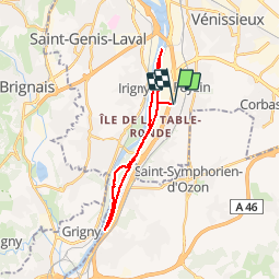
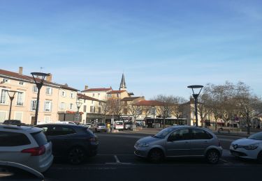
Trail Mountain bike of 21 km to be discovered at Auvergne-Rhône-Alpes, Métropole de Lyon, Feyzin. This trail is proposed by tracegps.
Description
Tour de l'Ile de la Table ronde, sur le Rhône au sud de Lyon. Je démarre généralement du bas du village de Feyzin, on accède ainsi à l'île sans trop de circulation automobile, ce qui est idéal avec des enfants notamment. La parcours suit le chemin de halage sur la rive du côté du Rhône et un single track en forêt de l'autre côté. Ballade assez simple et calme mais pouvant être désagréable en fonction des produits raffinés sur le site de Feyzin, je me suis fait prendre une fois... On peut prévoir une pause à l'extrémité sud de l'île, au milieu du fleuve.
Positioning
Comments
Trails nearby
![Trail Walking Vernaison - 69_Vernaison Rhône_12km_150m - Photo](https://media.geolcdn.com/t/375/260/a98e33a3-1aa3-45f3-bb3d-3d1de1405e03.jpg&format=jpg&maxdim=2)
![Walking Walking](https://static1.geolcdn.com/sitytour/trail-icons/101.png)
Walking
![](/images/other/stat-length.png)
![](https://static1.geolcdn.com/siteimages/upload/files/16400158638029165_repeat_loop_refresh_sync_direction_icon.png)
![Trail On foot Feyzin - Sentier des Alouettes - Photo](https://media.geolcdn.com/t/375/260/196abbf9-cf3c-423e-8745-e82f535258da.jpeg&format=jpg&maxdim=2)
![On foot On foot](https://static1.geolcdn.com/sitytour/trail-icons/100.png)
On foot
![](/images/other/stat-length.png)
![](https://static1.geolcdn.com/siteimages/upload/files/16400158638029165_repeat_loop_refresh_sync_direction_icon.png)
![Trail Walking Saint-Genis-Laval - L'observatoire de Lyon- Brignais- Les Aqueducs de Gier- St Genis Laval - Photo](https://media.geolcdn.com/t/375/260/8bf47eb3-04f1-4768-862e-a5372f47da3b.jpg&format=jpg&maxdim=2)
![Walking Walking](https://static1.geolcdn.com/sitytour/trail-icons/101.png)
Walking
![](/images/other/stat-length.png)
![](https://static1.geolcdn.com/siteimages/upload/files/16400158638029165_repeat_loop_refresh_sync_direction_icon.png)
![Trail Walking Saint-Genis-Laval - Les Collonges- Malataverne- Beaunant - Photo](https://media.geolcdn.com/t/375/260/24c8f286-0571-4669-ae45-4939e7c20733.jpg&format=jpg&maxdim=2)
![Walking Walking](https://static1.geolcdn.com/sitytour/trail-icons/101.png)
Walking
![](/images/other/stat-length.png)
![](https://static1.geolcdn.com/siteimages/upload/files/16400158638029165_repeat_loop_refresh_sync_direction_icon.png)
![Trail Walking Saint-Genis-Laval - Saint Génis - Beaunant - La Mulatière - Photo](https://media.geolcdn.com/t/375/260/a8db44dd-6d68-42e5-8cf9-a9e7be364e58.jpg&format=jpg&maxdim=2)
![Walking Walking](https://static1.geolcdn.com/sitytour/trail-icons/101.png)
Walking
![](/images/other/stat-length.png)
![](https://static1.geolcdn.com/siteimages/upload/files/16400158638029165_repeat_loop_refresh_sync_direction_icon.png)
![Trail Walking Saint-Genis-Laval - Saint Genis - Le Garon - Beauversant - Photo](https://media.geolcdn.com/t/375/260/1c40ffd6-cfce-4e76-bc42-0737a1fc036f.jpg&format=jpg&maxdim=2)
![Walking Walking](https://static1.geolcdn.com/sitytour/trail-icons/101.png)
Walking
![](/images/other/stat-length.png)
![](https://static1.geolcdn.com/siteimages/upload/files/16400158638029165_repeat_loop_refresh_sync_direction_icon.png)
![Trail Mountain bike Corbas - Corbas bois de st jean - Photo](https://media.geolcdn.com/t/375/260/ce84024e-6114-4bc0-bf26-193adabf40f8.jpg&format=jpg&maxdim=2)
![Mountain bike Mountain bike](https://static1.geolcdn.com/sitytour/trail-icons/202.png)
Mountain bike
![](/images/other/stat-length.png)
![](https://static1.geolcdn.com/siteimages/upload/files/16400158638029165_repeat_loop_refresh_sync_direction_icon.png)
![Trail Cycle Saint-Priest - St Priest - L'isle d'abeau Les 3 vallons - Photo](https://media.geolcdn.com/t/375/260/ext.jpg?maxdim=2&url=https%3A%2F%2Fstatic1.geolcdn.com%2Fsiteimages%2Fupload%2Ffiles%2F1524743154velo.jpg)
![Cycle Cycle](https://static1.geolcdn.com/sitytour/trail-icons/200.png)
Cycle
![](/images/other/stat-length.png)
![](https://static1.geolcdn.com/siteimages/upload/files/16400158638029165_repeat_loop_refresh_sync_direction_icon.png)
![Trail Other activity Marennes - iveco - Photo](https://media.geolcdn.com/t/375/260/ext.jpg?maxdim=2&url=https%3A%2F%2Fservices.sitytrail.com%2FGeolivesWS%2FDownloadMedia.ashx%3FTrailID%3D40090%26Media%3Dimage3.jpg)
![Other activity Other activity](https://static1.geolcdn.com/sitytour/trail-icons/900.png)
Other activity
![](/images/other/stat-length.png)
![](https://static1.geolcdn.com/siteimages/upload/files/16400158638029165_repeat_loop_refresh_sync_direction_icon.png)